
For centuries, the mysteries of clouds have intrigued philosophers such as René Descartes, who expressed the overwhelming challenge of explaining their nature. Clouds come in many shapes and sizes, governed by both the meteorological conditions of where they form and the properties of aerosol particles that seed them. The climate implications of diverse clouds, from wispy high-altitude cirrus to puffy marine cumulus, can vary widely depending on their location, altitude, and surrounding atmospheric environment.
The lack of understanding of clouds and their interactions with aerosols represents the largest source uncertainty in climate models, creating an urgency to study them more thoroughly.
Perhaps the clearest demonstration of interactions between clouds and aerosol particles dates to the 1960s, when NASA launched the Television Infrared Observation Satellite (TIROS) to determine whether satellites could be used to study Earth. TIROS imagery revealed bright lines in the sky that we now refer to as ship tracks. These bright lines are clouds that form from various particles emitted by ships that can act as cloud condensation nuclei (CCN). Water vapor in the atmosphere condenses around these CCN, which are also produced by many different natural and anthropogenic sources, forming large numbers of small cloud droplets [Twomey, 1974].
That ship tracks are complex phenomena is well documented. For example, even though there are ships at sea all the time, these bright cloud lines are not always observed. (In a similar manner, contrails do not always appear behind jet aircraft when they are aloft.) So although ship tracks provide a striking illustration of aerosol-cloud interactions, the detailed interplay of anthropogenic aerosols, natural continental and marine emissions, clouds, and meteorology that determines their behaviors and traits—and, indeed, the behaviors and traits of most clouds—is more subtle and not well understood.
This lack of understanding of clouds and their interactions with aerosols represents the largest source of uncertainty in climate models, creating an urgency to study them more thoroughly. Now a major NASA airborne science campaign has set out to illuminate elusive details about these atmospheric enigmas to better inform projections of human-caused climate change.
Two Planes, One Mission
Improving model simulations of clouds requires a deeper understanding of how they form and evolve. To guide this understanding, researchers have developed airborne sampling strategies that target air in and around clouds during brief, intensive field campaigns. However, this episodic approach produces only small numbers of discrete samples and limited coverage of the variety of cloud behaviors.
For instance, field studies usually last only a few consecutive weeks in a small geographic region, which reduces the range of aerosol and cloud types that can be studied. And single aircraft missions cannot simultaneously capture all of the information relevant to aerosol-cloud interactions throughout the column of the lower atmosphere, especially because clouds evolve on timescales of only minutes and because atmospheric particles and meteorological conditions can vary from one side of a cloud to another.
Thus, data from such intensive, short-duration campaigns are typically insufficient for disentangling influences of meteorology (e.g., wind and humidity) and aerosols on cloud behavior, as well as for understanding how clouds, in turn, affect particles. These limitations hamper efforts to improve how aerosol-cloud interactions are represented in global models.

The NASA Aerosol Cloud Meteorology Interactions over the Western Atlantic Experiment (ACTIVATE) was born of the recognition of these past challenges and from the need for sustained long-term aircraft measurements to tackle specific Earth science questions [Sorooshian et al., 2019].
ACTIVATE involves two aircraft housed at NASA’s Langley Research Center (LaRC) in Hampton, Va. These aircraft fly in synchrony within a systematic flight strategy over the western North Atlantic Ocean (WNAO) in different seasons.
The NASA LaRC HU-25 Falcon collects measurements of gases, aerosols, clouds, and meteorological conditions (e.g., temperature, humidity, winds) in the lowest layer of the atmosphere (called the boundary layer) below about 2 kilometers in altitude, to which surface aerosol emissions are mostly confined. When the plane is in a cloud, specialized instrumentation enables collection and chemical characterization of cloud water and the elusive CCN particles.

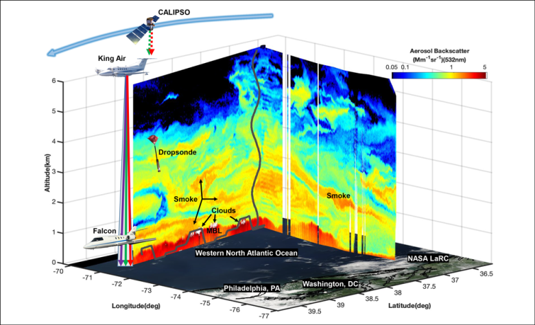
As the Falcon samples within and just above the boundary layer, the NASA LaRC UC-12 King Air simultaneously flies directly above it at an altitude of 8–10 kilometers, using remote sensing instrumentation to study the same aerosols and clouds sampled in situ by instruments on the Falcon. The High Spectral Resolution Lidar 2 (HSRL-2) and the Research Scanning Polarimeter on board the King Air measure light scattered by aerosols and clouds to determine how these materials are distributed vertically, their amount and size, and how they scatter light. The equipment on the King Air also helps NASA develop and test instrument technology and algorithms designed to retrieve complex aerosol and cloud properties from satellite observations. Further, the King Air launches dropsondes to measure cross-sectional profiles of winds, temperature, and humidity through the atmospheric column.
The ACTIVATE mission extends over several years and will observe how aerosols and clouds in the same atmospheric column interact under a variety of conditions.
ACTIVATE flights, which began in 2020 and are slated to occur through 2022, are planned for February–March and May–June each year to capture different aerosol and meteorological regimes over the WNAO. Paired morning and afternoon flights on the same day, called process study flights, allow the aircraft to follow a given air mass at multiple times of day to track its evolution. This approach, called Lagrangian tracking, is helpful because clouds adjust to aerosol fluctuations within a given meteorological context over a span of many hours [Mülmenstädt and Feingold, 2018].
Because the ACTIVATE mission extends over several years, it will be able to acquire repeated samples to observe how aerosols and clouds in the same atmospheric column interact under a variety of conditions. This perspective is not possible when areas are sampled only once or twice.
Adjusting to the Pandemic
Twenty-two research flights—17 with both planes and 5 with just the Falcon—were conducted during the 2020 winter deployment (February–March), and another 18 joint flights were conducted that summer (August–September). The latter deployment was delayed from May–June owing to restrictions associated with the COVID‑19 pandemic, which required ACTIVATE scientists and crew to adapt to virtual communications for planning and operations. Fortunately, crew members are locally based, which reduced their pandemic-related travel risks. Also, operating the extensive instrumentation aboard the two relatively small aircraft requires only a small number of flight scientists.
A Wealth of Observations Already
For decades, the U.S. East Coast and adjacent offshore areas have been targeted for atmospheric research because of the prevailing winds that bring extensive urban pollution from land to the ocean. This flow produces spatial gradients in aerosol and cloud properties of interest [Corral et al., 2021; Sorooshian et al., 2020].

For example, the first year of ACTIVATE flight data revealed a broad range of cloud droplet number concentrations over the WNAO spanning several orders of magnitude (H. Dadashazar et al., Cloud drop number concentrations over the western North Atlantic Ocean: Seasonal cycle, aerosol interrelationships, and other influential factors, submitted to Atmospheric Chemistry and Physics, 2021). Enumerating this range is critical for understanding key fundamental drivers of this cloud microphysical variable, which can influence weather and climate by affecting how clouds reflect solar radiation. Higher aerosol particle concentrations generally increase droplet number concentrations and decrease droplet sizes (other variables being fixed), for example, leading to a higher albedo and greater reflection of shortwave radiation.
The region monitored by ACTIVATE is also of interest because it hosts diverse and seasonally changing conditions, allowing us to study a range of cloud behaviors. During the first two flight seasons, for example, the aircraft sampled clouds consisting variably of warm (liquid) and mixed-phase droplets (liquid and ice) in addition to overcast cloud scenes, scattered cumulus clouds, postfrontal clouds, and cloud-free air [Painemal et al., 2021].
The WNAO is also subjected to frequent cold air outbreaks (CAOs) from polar and subpolar latitudes in winter, which lead to “cloud streets” of shallow cumulus clouds that form after a CAO front passes. Because models often underrepresent these postfrontal shallow clouds in the study region, we were strongly motivated to take a deeper look at these events [Rémillard and Tselioudis, 2015]. During the winter 2020 campaign, we captured observations of several such events during morning and afternoon process study flights. The data from these flights have aided large-eddy simulations of unsteady turbulent flows in the atmosphere that contribute to the formation of cloud streets as cold air masses move with the wind.
The observations collected during CAOs, when the marine boundary layer is remarkably dry, will also allow for new analyses contrasting aerosol characteristics under these conditions with those during more regularly observed humid conditions. For example, sea salt particles are nonspherical in drier air, which has major implications for how their optical properties are represented in models and in retrieval algorithms for satellite aerosol data [Ferrare et al., 2020].
During the 2020 summer campaign, the two aircraft had an opportunity to collect data on smoke-cloud interactions.
During the summer campaign, the two aircraft had an opportunity to collect data on smoke-cloud interactions. The HSRL-2 on the King Air detected smoke aerosol plumes at altitudes of about 2–8 kilometers that were traced back to wildfire emissions from California and other parts of the western United States. Real-time displays of the HSRL-2 measurements of aerosol and cloud distributions allowed the King Air flight scientists to advise the Falcon flight scientists of optimal altitudes at which to collect in situ data. These data are being used to study how the clouds and smoke particles affected each other: Does smoke above the boundary layer promote cloud formation? Do clouds dissipate when smoke mixes with clouds in the boundary layer?
Because ACTIVATE’s flight domain overlaps the Gulf Stream, the warm ocean current that sweeps up the U.S. East Coast before crossing the North Atlantic, we can also observe how gradients of cold and warm waters affect cloud and aerosol distributions, presenting another set of promising research pathways. These temperature gradients may, for example, influence gradients of heat flux between the ocean and the atmosphere that, in turn, affect boundary layer structure and cloud fields. Resulting spatial variations in boundary layer turbulence, especially during CAOs, have important implications for aerosol-cloud interactions that remain poorly understood and under investigation with ACTIVATE data.
Advancing Atmospheric Remote Sensing
Flights in which aircraft under-fly satellites are challenging to plan and conduct, especially when synchronizing multiple aircraft, yet these flights are important for assessing satellite sensor performance and improving remote sensing algorithms. ACTIVATE is highly useful in such efforts: Last summer, for example, we conducted multiple flights to under-fly NASA’s Cloud-Aerosol Lidar and Infrared Pathfinder Satellite Observation (CALIPSO) satellite when it passed over the WNAO (Figure 1).
ACTIVATE also supports the high-priority aerosol-cloud designated observable research areas recommended in the most recent Decadal Survey for Earth Science and Applications from Space [see National Academies of Sciences, Engineering, and Medicine, 2018]. This survey highlights the need to integrate airborne data collection using polarimeters and lidars—sensors that ACTIVATE deploys. Combining polarimeter and lidar data may, for example, allow for improved remote study of the formation of drizzle (water droplets that are smaller than raindrops) through the simultaneous retrieval of cloud droplet number concentrations and droplet size distributions at cloud tops [Cairns et al., 2020]. Furthermore, the joint use of both types of remote sensing data sets allows for evaluation of the rates at which cloud droplets grow into drizzle drops, known as autoconversion rates, which climate models currently treat with substantial uncertainty.
The ACTIVATE team recently completed winter 2021 flights (January–March) and is in the process of conducting flights in the May–June 2021 time frame. Pandemic restrictions are not preventing the team’s ability to execute successful science flights. In addition, extensive analyses of data collected during the 2020 flights are underway, and a workshop is planned for fall 2021 to promote broader use of the publicly available data by the international research community.
Through these efforts, the ACTIVATE team and other scientists will shed valuable light on the perplexing properties of clouds that intrigued Descartes and have captivated so many others since and that integrally influence our planet’s weather and climate.
Acknowledgments
ACTIVATE is a NASA Earth Venture Suborbital-3 (EVS-3) investigation, funded by NASA’s Earth Science Division and managed through the Earth System Science Pathfinder program office.
References
Cairns, B., et al. (2020), Using remotely sensed cloud top properties to look at drizzle formation, Abstract A158-07 presented at 2020 Fall Meeting, AGU, 1–17 Dec., agu.confex.com/agu/fm20/meetingapp.cgi/Paper/734416.
Corral, A. F., et al. (2021), An overview of atmospheric features over the western North Atlantic Ocean and North American East Coast – Part 1: Analysis of aerosols, gases, and wet deposition chemistry, J. Geophys. Res. Atmos., 126(4), e2020JD032592, https://doi.org/10.1029/2020JD032592.
Ferrare, R. A., et al. (2020), Airborne high spectral resolution lidar-2 measurements of enhanced depolarization in marine aerosols, Abstract A035-0001 presented at 2020 Fall Meeting, AGU, 1–17 Dec., agu.confex.com/agu/fm20/meetingapp.cgi/Paper/692428.
Mülmenstädt, J., and G. Feingold (2018), The radiative forcing of aerosol–cloud interactions in liquid clouds: Wrestling and embracing uncertainty, Curr. Clim. Change Rep., 4(1), 23–40, https://doi.org/10.1007/s40641-018-0089-y.
National Academies of Sciences, Engineering, and Medicine (2018), Thriving on Our Changing Planet: A Decadal Strategy for Earth Observation from Space, 716 pp., Natl. Acad. Press, Washington, D.C., https://doi.org/10.17226/24938.
Painemal, D., et al. (2021), An overview of atmospheric features over the western North Atlantic Ocean and North American East Coast—Part 2: Circulation, boundary layer, and clouds, J. Geophys. Res. Atmos., 126(6), e2020JD033423, https://doi.org/10.1029/2020JD033423.
Rémillard, J., and G. Tselioudis (2015), Cloud regime variability over the Azores and its application to climate model evaluation, J. Clim., 28(24), 9,707–9,720, https://doi.org/10.1175/JCLI-D-15-0066.1.
Sorooshian, A., et al. (2019), Aerosol–cloud–meteorology interaction airborne field investigations: Using lessons learned from the U.S. West Coast in the design of ACTIVATE off the U.S. East Coast, Bull. Am. Meteorol. Soc., 100(8), 1,511–1,528, https://doi.org/10.1175/BAMS-D-18-0100.1.
Sorooshian, A., et al. (2020), Atmospheric research over the western North Atlantic Ocean region and North American East Coast: A review of past work and challenges ahead, J. Geophys. Res. Atmos., 125(6), e2019JD031626, https://doi.org/10.1029/2019JD031626.
Twomey, S. (1974), Pollution and the planetary albedo, Atmos. Environ., 8(12), 1,251–1,256, https://doi.org/10.1016/0004-6981(74)90004-3.
Author Information
Armin Sorooshian (armin@arizona.edu), Department of Chemical and Environmental Engineering and Department of Hydrology and Atmospheric Sciences, University of Arizona, Tucson; and Joseph Atkinson, Richard Ferrare, Johnathan Hair, and Luke Ziemba, NASA Langley Research Center, Hampton, Va.
Citation:
Sorooshian, A., J. Atkinson, R. Ferrare, J. Hair, and L. Ziemba (2021), Taking flight to study clouds and climate, Eos, 102, https://doi.org/10.1029/2021EO158570. Published on 19 May 2021.
Text © 2021. The authors. CC BY-NC-ND 3.0
Except where otherwise noted, images are subject to copyright. Any reuse without express permission from the copyright owner is prohibited.