
Preliminary Assessment of the Geological and Mining Heritage of the Golden Quadrilateral (Metaliferi Mountains, Romania) as a Potential Geotourism Destination

Geological Institute of Romania, 1 Caransebeș Street, RO-012271 Bucharest, Romania
Sustainability 2021, 13(18), 10114; https://doi.org/10.3390/su131810114
Submission received: 13 June 2021
/
Revised: 13 August 2021
/
Accepted: 4 September 2021
/
Published: 9 September 2021
(This article belongs to the Special Issue The Sustainable Management of Geodiversity: Following Studies on Heritage for Conservation)
Abstract
:The Metaliferi Mountains (Western Romania) are known worldwide as the richest gold region in Romania and hosts for numerous porphyry and epithermal deposits. In these mountains, mining for gold dates back to Roman and even pre-Roman times. The Golden Quadrilateral constitutes a remarkable example of an area having a significant geological and mining heritage. The main purposes of this work are to emphasize this heritage, to present, for the first time, an assessment of the geological and mining heritage of the Golden Quadrilateral as a possible geotourism destination, and to point out the important role that geotourism could have in the sustainable development of local communities. To achieve our goals, the features of thirteen sites are presented, and two geotourism itineraries are proposed. A quantitative assessment of the geosites’ capacity to support scientific, educational, and geotourism/recreational uses indicates that the Golden Quadrilateral presents a high potential not only for scientific studies but, also, for enhancement of the public understanding of science; geotourism could be part of the development strategy of rural areas. The two museums (Gold Museum and Gold Mining Museum) can have an important contribution both to the geo-education of visitors and in promoting the sustainable development of the region.
1. Introduction
Over the last three decades, a rapidly increasing number of studies focusing on geodiversity, geoheritage, and geotourism has been published (e.g., References [1,2,3,4,5,6,7,8,9,10,11,12,13,14,15]). Geodiversity is a term that was defined by Sharples [1,2] as “the range (or diversity) of geological (bedrock), geomorphological (landform) and soil features, assemblages, systems and processes”. The definition of this term has evolved over time, and it is now commonly used as “the natural range (diversity) of geological (rocks, minerals, fossils), geomorphological (landforms, topography, physical processes), soil and hydrological features. It includes their assemblages, structures, systems and contributions to landscapes” [7]. In 1996, Wimbledon [4] proposed the term of geosite to refer to “any site that contains significant geodiversity”. According to Brocx and Semeniuk [5], geoheritage encompasses the “features of geology, at all scales that are intrinsically important sites or culturally important sites offering information or insights into the evolution of the Earth”, concentrating on the diversity of minerals, rocks and fossils, and the petrogenetic indicators related to them. Geomorphological features (e.g., landforms) illustrating Earth and climate processes are also included in this concept. Mining heritage is a comprehensive term that includes anything related to active and inactive mining, “such as minerals and rocks that are being (or were) extracted, industrial facilities, historical documentation of old mines”, mining processes and technology, “and even mining communities’ stories and traditions” [10]. Mining heritage is viewed as being at the interface between geoheritage (georesource) and cultural heritage [16]. As regards the term geotourism, it is relatively new. Geotourism is considered a geosite-based activity focused on geology and landscape and meant to promote geodiversity conservation and facilitate the understanding of Earth Sciences [17,18]. It is a form of tourism that contributes to the discovery of “geological peculiarities of the visited territories, combined with other natural and human resources” [19]. As for the inventory and quantitative assessment of the geosites, different methodologies have been proposed over the past two decades. Thus, there are methodologies that focus on the assessment of: geomorphosites (e.g., References [8,20,21]), geodiversity and geodiversity loess [22], the planning and management of the natural heritage sites as potential tourist attractions [23], geoheritage and geodiversity sites [10,11], etc.
Our study area is located in the Apuseni Mountains (Western Romania), namely in the Metaliferi Mountains (Metaliferi means Metalliferous in Romanian), an area with a significant geological and mining heritage. In Romania, a major step in direction of regulation in the domain of natural heritage was made in 1930 by the promulgation of Law no. 213/1930 for the protection of the natural monuments of Romania [24,25,26]. Since then, more and more natural areas have been protected. For instance, in 1935, the first natural park was declared in the Retezat Mountains (South Carpathians). The first Romanian natural monument of geological interest, established in 1938, was Detunata Goală [24,27], one of the protected areas presented in this work. Nowadays, the Romanian’s National Network of Protected Natural Areas contains 975 protected natural areas of national interest and 18 protected natural areas of international interest [28,29,30]. In Romania, a member state of the European Union, the legislation on natural protected areas reflects the transposition of the European legislation directives in the country’s legislation. The National Agency for the Protected Natural Areas (ANANP) provides the framework for the management of protected natural areas [29]. Likewise, the Romanian National Institute of Heritage (under the authority of the Ministry of Culture) is in charge, with the activities of inventory, protection, and enhancement of cultural heritage [31,32].
Considered an important part of heritage, in Europe, there are hundreds of tourist caves and tourist mines [33], some of them being visited by a huge number of tourists every year (e.g., Postojna Caves, Slovenia; Drach Caves, Spain; Castellana Caves, Italy; Wieliczka Salt Mine, Poland; Lewarde Mining History Centre, France; Grand-Hornu Mine, Belgium). In Romania, the most developed underground tourism is the tourism in the salt mines (salinas) (Salina Turda in Cluj County; Salina Praid in Harghita County, Salina Slănic in Prahova County, Salina Ocnele Mari in Vâlcea County, etc.), annually visited by hundreds of thousands of Romanians and foreign tourists. Less developed (but still with a large number of participants) is the tourism in caves, mostly of them included in protected areas (e.g., Bear’s Cave, Meziad Cave, and Scărișoara Cave in Apuseni Natural Park). Underground tourism within an ore deposit mine is possible only in one place, at Roșia Montană (Alba County), in a site that is described in this study.
While, in many countries of Europe, geotourism has been developing for more than two decades, it is just emerging in Romania. It can be said that a step in this direction was taken with the establishment (in 2004) of the “Hațeg Country Dinosaurus Geopark” (“Hațeg Geopark”), the only Romanian geopark included in the European Geoparks Network (EGN) and UNESCO Global Geoparks (UGGp) [34]. It is situated approximately 35 km southwest of our study area.
Known worldwide for their ore deposits and mineralogical diversity and having a high geological complexity, the Metaliferi Mountains have been studied for more than 250 years and still present a high scientific interest (e.g., References [35,36,37,38,39,40,41,42,43,44,45,46,47,48]).
Mining for gold in the area of the Metaliferi Mountains dates back to Roman and even pre-Roman times. There are historical and archaeological data that sustained the existence of mining activity long before the conquest of Dacia by Roman armies in AD 106 (during the rule of Trajan, the Roman emperor from A.D. 98 to 117) (e.g., References [31,32,38,49,50,51,52]). Late in the 19th century and early in the 20th century, the exploitation of gold and other precious metals in this region was highly intensified. It seems that the name of the Golden Quadrilateral (Patrulaterul Aurifer in Romanian) started to be used at the beginning of the 20th century to emphasize the richness in the ore deposits of these mountains. At that time, the region was one of the main centers of mining and extraction of gold in Europe. The Golden Quadrilateral delimited the area containing the ore deposits, the corners of the quadrilateral represented by the following localities: Săcărâmb (in the south), Zlatna (in the east), Baia de Arieș (in the northeast), and Caraci (in the northwest) [39,40,49] This area is shown in Figure 1a,b (the area delimited by the orange full line).
In the last two centuries, mining was one of the main sources of revenue for many people living in the region of the Metaliferi Mountains. However, in the 1990s began the decline of mining activities, which almost ceased in the 2000s.
The main purposes of this work are: (i) to highlight the important geological and mining heritage of the Golden Quadrilateral through inventory and a description of the characteristics and particularities of the sites, (ii) to present the first quantitative assessment of the geosites of the Golden Quadrilateral as a geotourism destination, and (iii) to promote geotourism in the Metaliferi Mountains as a potential source of sustainable development at the local and regional levels.
2. Study Area
The Metaliferi Mountains are part of the South Apuseni Mountains. In the north, the Crișul Alb River and the Arieș River delimit the Metaliferi Mountains from the North Apuseni Mountains. The Mureș River constitutes their southern and southeastern limits. To the east, beyond the Ampoi Valley (the easter limit of the Metaliferi Mountains), there are the Trascău Mountains. West of the Metaliferi Mountains, there are the Zarand Mountains. The regional geomorphology is characterized by hilly to mountainous reliefs. The elevation ranges from about 180–200 m above sea level (a.s.l.) (the Mureș Riverbed between Deva and Simeria) to 1348 m a.s.l. (in Vâlcoi Peak), and, further to the northeast, to 1437 m a.s.l. (in Poieniței Peak).
The Golden Quadrilateral, as it was initially imagined, is entirely enclosed in the Metaliferi Mountains area (Figure 1a,b). However, in this study, the extended meaning of the Golden Quadrilateral will be used, meaning a larger area resulting from the discovery of new ore deposits, including beyond the primary boundaries of the Golden Quadrilateral (≅study area in Figure 1b). For instance, it is the case of the Deva porphyry Cu-Au deposit located immediately south of the Metaliferi Mountains (near the city of Deva) and related to the same Neogene magmatism as the ore deposits of the Golden Quadrilateral.
From a geological point of view, the Apuseni Mountains consist in Alpine tectonic units made predominantly of Pre-Mesozoic crystalline rocks overlain by Permian-Mesozoic sedimentary covers or of Jurassic ophiolites and calc-alkaline volcanic rocks and their associated sediments [45,53,54]. Late Cretaceous magmatites and Cenozoic igneous and sedimentary rocks are also well-developed.
Long-term, the Neogene magmatism of the South Apuseni Mountains has been interpreted as subduction-related magmatism [40,55]. During the last three decades, complex geological studies have shown that Neogene volcanism is post-collisional, generated in a transtensional regime [46,47,56]. In the South Apuseni Mountains, the magmatic activity started around 15 Ma with explosive activity (widespread volcano-sedimentary sequences), followed by intense volcano-intrusive activity (complex volcanic/subvolcanic structures) between 14.7 and 7.4 Ma [47,57]. To note, a volcanic episode related to the activity on the South Transylvanian Fault System took place in the Quaternary; it is represented by the occurrence of Măgura Uroiului Hill (see Section 4.1.1).
The Metaliferi Mountains are known worldwide as the richest metallogenic region of Romania and hosts for numerous Au-Ag-(Te) or Pb-Zn-Cu-(Au, Ag) epithermal and porphyry Cu-(Au-Mo) deposits [38,39,43,44,48,58]. These deposits are related to Neogene magmatism. The main metallogenic events took place in the Middle to Late Miocene. The ore deposits are distributed in four metallogenic fields: Brad-Săcărâmb, Zlatna-Stănija, Roșia Montană-Bucium, and Baia de Arieș.
Mining artifacts discovered in the area of the Apuseni Mountains suggest that the first mining works date back to Late Neolithic when gold was exploited at the surface (mainly alluvial gold) [31,32,38,49,52]. During the Roman Dacia (from 106 to 271–275 A.D.), in the Medieval period and, also, in the 18–20th centuries, the Metaliferi Mountains were one of the most important gold mining regions of Europe. The exploration and exploitation of precious metals boomed in the 18th and 19th centuries and continued to be important in the 20th century [59]. Eighty years ago, Ghițulescu and Socolescu [38] noted that, during that time, starting with the Roman period, the total quantity of extracted gold from the Metaliferi Mountains was about one thousand tonnes and that the mountains “still contain important quantity of gold”. To emphasize how important and developed mining was in this region, notes that, on the “Geological and mining map of the Metaliferi Mountains and surrounding areas”, scale 1:75,000 [38,60], 441 mine adits are localized, and a list of their name is presented. After World War II, the Metaliferi Mountains continue to be the main golden exploitation center of the country. Traces of old mining works can still be seen in many places in the Metaliferi Mountains. Mining almost stopped in the 1990s–2000s, mainly due to: (i) the lack of economic efficiency, (ii) mine exhaustion, and (iii) waiting for: new exploration works and results and new technologies for metal extraction.
3. Materials and Methods
The materials used for this paper include: (i) published literature related to the topic of this work and the study area; (ii) geological maps at different scales as Geological map of Romania scale 1:1,000,000 [61], geological maps of Romania, scale: 1:50,000 [62,63,64,65,66,67]; (iii) Map of mineral resources of Romania, scale 1:1,000,000 (with representative areas and explanatory notes) [68]; (iv) topographic maps. The scientific literature review of relevant articles provided an essential part of information needed for presentation of the characteristics of the geological and mining heritage sites.
Regarding the methods used for this contribution, it is to note both the fieldwork realized strictly for the purposes of the study, and the fieldwork undertaken by author during the research for different topics (e.g., geological mapping; petrological, geochemical, metallogenic, and environmental studies) [69,70,71]. Field trip missions organized for preparations of several geological excursions in the South Apuseni Mountains and the excursions themselves represented an opportunity both to accumulate field data and to notice the interest of specialists and students in geosciences for this region (e.g., Reference [72]). In the area of each geosite included in this study, field observations, descriptions and measurements were performed. Besides the observations related to the geological and geomorphological characteristics of the geosites, during the fieldwork, for each geosite, were collected data regarding accessibility, vulnerability, integrity, use limitations, safety, observation conditions, scenery, associations with other values, proximity of recreational areas, deterioration of geological elements, etc. The paper author took all the photographs used in this work. Supplementary data were obtained by macroscopic and microscopic study of rock fragments collected during the field missions. Their mineralogical and petrographic characteristics were determined by optical microscopy; the obtained results have been integrated within the description of geosites (Section 4.1.1). As for the methodologies used in this study, it is to mention: the inventory and characterization of the sites of interest; the evaluation of geological and mining heritage of the sites; the proposal of two geoitineraries and description of the included sites; the qualitative assessment of the sites included in the two geoitineraries as potential sites for scientific, educational, and geotourism/recreational uses; the assessment of their degradation risk. The evaluation of the sites is based on field work and literature review; for designation category and year of designation of geosites, data furnished by National Agency for Natural Protected Areas (ANANP) [29,30]. The online databases of the National Heritage Institute [31] and the National Archaeological Registry [32] were also used in this study; data provided by National Institute of Statistics were used too. For the sites included in the two proposed geoitineraries a description, emphasizing their particularities, is presented.
As it was mentioned in Section 1 (Introduction), for the inventory and quantitative assessment of the geosites, different methodologies have been proposed (e.g., References [8,9,10,11,22,23]). Due to the fact that Brilha methods [10,11] are applicable both to geological heritage and the geodiversity sites, they are used in this study. Besides, at the beginning of this research, for the first studied geosites (field observations and information), I used criteria and indicators according with these methods. Later, during the fieldwork for the rest of geosites, I continued to use the same criteria and indicators in order to have a uniform set of data.
The quantitative assessment of the geosites consists in the numerical evaluation of the sites’ capacity to support scientific, educational, and geotourism/recreational uses and in quantitative assessment of the sites’ degradation risk [10,11]. These evaluations are based on specific criteria; each criterion is characterized by three or four indicators quantified by a numerical parameter (a value accorded of the selected indicator). Each criterion has been assigned a weight (%). The final score for a criterion is obtained by multiplying the value of selected indicator with correspondent weight of the criterion. The sum of the final values of specific criteria gives the final score of potential uses and degradation risk of a site. Thus, quantitative assessment of the geosites’ capacity to support educational use is based on twelve criteria. Quantitative assessment of the geosites’ capacity to support geotourism/recreational use is based on thirteen criteria. To note that the first ten criteria of the two potential uses are the same, namely: vulnerability, accessibility, use limitations, safety, logistics, density of population, association with other values, scenery, uniqueness, and observation conditions. The two other criteria of potential educational use are didactic potential and geological diversity. The three other criteria for potential geotourism/recreational use are: interpretative potential, economic level, and proximity of recreational areas. Each criterion is ranked with 1, 2, 3, or 4 points (according to the value of the selected indicator); each criterion has been assigned a weight (%). For more details, see Section 4.2. During this work, a particular attention was paid to the evaluation of the sites for geotourism, and educational use. In this regard, some other criteria were taken on consideration as well [8,9,13,15,73].
4. Results
4.1. Inventory of Geological and Mining Heritage of the Study Area
The natural protected areas of national relevance of Romania are divided into five categories: scientific reserves, national parks, nature reserves, natural monuments, and natural parks [29]. Based on detailed field investigations and the literature review, an inventory of the geological and mining heritage sites located in the studied area has been realized. The obtained results are summarized in Table 1. In this table, for each site, the following elements are presented: site number, site location (locality and GPS coordinates), main features, a short description, and potential values. The location of each site is shown in Figure 1b. The inventory contains nine geosites of national relevance as follows: five nature reserves and four natural monuments. For these sites, the designation category and year of designation are also indicated (Table 1).
In addition to the geosites from Table 1, in the Metaliferi Mountains, there are a few more natural protected areas (sites of geological and/or geomorphological significance). They are not included in this work, because they are located in the south–southeast part of the Metaliferi Mountains, outside of the considered limit of the Golden Quadrilateral.
The aspects regarding the biodiversity of the natural area are not discussed in this paper.
Besides the nine geosites from Table 1, in this inventory, I also introduced:
- (i)
- The village of Săcărâmb (former Nagyág) (site no. 3 in Table 1 and Figure 1b), due to its importance for mining history not only of the Apuseni Mountains but, also, of Europe. Săcărâmb is an epithermal Au-Ag-tellurides ore deposit, world-famous for its richness in precious minerals and, especially, for the very high contents in gold and tellurides. The ore deposit was discovered in 1740s [38,44,49], and since then, the Săcărâmb mines have been in production for over 250 years. The mining activity ceased in 2006. Săcărâmb is the type locality for eight minerals (see below). Figure S1a shows the location of the Săcărâmb Village in an area with volcanic structures of Neogene age. An image taken in this village is presented in Figure S1b, in which, in the foreground, a dry stone fence made of andesites (the main volcanic rock occurring in this area) can be seen. This construction technique, used in some of villages in the Apuseni Mountains, gives a special charm to the villages and should be preserved;
- (ii)
- The “Roman Stairs” Mine Gallery (site no. 5 in Table 1 and Figure 1b), an important mining heritage from Roman period in Dacia (2nd to 3rd centuries A.D.). At that time, Brad area was a very famous mining center for gold in Europe ([38] (pp. 394–396); [49] (pp. 106–109)). The adit of the Roman mine (Figure S2) is located on the left slope of Ruda Valley (a right tributary of the Luncoiul Stream), upstream of the village of Ruda-Brad. The mine was dug by hand (mainly with hammers and chisels) using the stairs method for the exploitation of the deeper part of the ore deposit. The “Roman Stairs” mine gallery is on the list of Historical Monuments of Romania (archaeological site) [31]. According to the Annex 3 of the Law no. 5/2000 [28], it is also a cultural heritage (historic monument of exceptional value), category: industrial architecture (from Roman times);
- (iii)
- (iv)
- The Gold Mining Museum in Roșia Montană, Alba County (site no. 8 in Table 1), a site of both mining and industrial architecture heritage, and historical and archaeological heritage.
More data about each of the two museums are presented in Section 4.1.1.
As it is shown in Table 1, each site present at least three of the six values (scientific, educational, tourism, mining heritage, archaeological and/or historical, and cultural) taken into account in order to evaluate them.
It is important to point out that the Metaliferi Mountains is a region where new minerals have been discovered. In order to illustrate the relevance of the studied area for the history of mineralogy, Table 2 shows the list of minerals discovered for the first time in the world, in the area of Golden Quadrilateral. For this table I used data from the list of minerals presented by International Mineralogical Association (IMA) [75] and also data from literature (for type localities) [44,76,77,78,79,80,81,82]. Location of each type locality is indicated in Figure 1b.
Therefore, from a scientific point of view, localities as Uroi, Săcărâmb, Roșia Montană (Table 1), are highly significant on an international scale, each of them been type locality for one or more of minerals listed in Table 2. It is to notice that eight of the fourteen minerals from Table 2 were discovered in the 19th century, fact that shows both the importance and the degree of development of mining (including the associated research work), at that time in this part of Europe. Spectacular specimens of minerals coming from the Golden Quadrilateral are exhibited in museums around the world.
In order to emphasize the characteristics and particularities of geological and mining sites in the study area and also to consider them in a possible sequence of visiting, here below two geotourism itineraries are proposed.
4.1.1. Two Proposed Itineraries
The two itineraries connect a series of sites of geological and mining interest; each site is briefly described. The itineraries are shown in Figure 1b as itinerary A (green line) and itinerary B (blue line). It is to note that these are two suggestions: the tourists may choose to follow only one of it or they could combine the visit of sites of these itineraries with other sites of interest. The participants at the two itineraries will see beautiful landscapes, volcanic and subvolcanic rocks, spectacular columns of basaltic andesites, olistoliths, reef limestones, rare minerals, etc. They will also visit two museums, the Gold Museum (in town of Brad, Hunedoara County) and the Gold Mining Museum (in Roșia Montană Village, Alba County), and a medieval fortress in Deva City (Hunedoara County). For diverse reasons, some of the sites shown in Table 1 are not included in these itineraries: it takes too much time to reach the site (Săcărâmb Village, Piatra Corbului, Piatra Despicată); the site is not yet open to visitors (“Roman Stairs” Mine Gallery; the municipality of Brad Town plans to open it); the site (Detunata Goală, included in one of the itineraries) is less easy to access as is another site (Detunata Flocoasă) with which it has common features.
With the aim of facilitating the preparation of an excursion to visit the sites included in the itineraries, I realized schematic presentations showing the two itineraries (Figure 2a) represented as in Figure 1b, and the distances between sites in correlation with time (time spent on place and travel time) (Figure 2b). The values for time are approximate values that depend on the visitor (or group of visitors) intention for time spent on place, the necessary time to attend a site, etc. The walk distance is the walk distance from travel vehicle (parking place) to the site; it does not include the walk distance within or around the site and neither the walk distance to return to the vehicle. Similarly, the walk time is just the time need to reach the site of interest.
In this work, the schema from Figure 2b was used mainly in the quantitative assessment of the sites and, therefore, including in the assessment of the geological and mining heritage of Golden Quadrilateral as potential tourism destination.
- First Itinerary (Itinerary A—Day 1)
First proposed itinerary contains five of the sites of Table 1, noted here (and on the Figure 1b and Figure 2) from AI to AV, as follows: AI. Citadel Hill (Deva); AII. Măgura Uroiului (Uroi, Simeria); AIII. Limestones from Măgura Hill (Băița); AIV. Gold Museum (Brad); AV. Vulcan Mountain (Buceș). Therefore, the itinerary includes four geosites and a museum. The length of the itinerary is about 100 km; all the sites are easy to access.
- AI.
- Citadel Hill
Location: Deva City; Hunedoara County
Citadel Hill is a remarkable landform in this area (Figure 3a–c) whose altitude is of 369.6 m above sea level (a.s.l). At the bottom of the hill, the altitude is of around 200 m a.s.l. The hill is a subvolcanic body consisting of andesites. The rock has a porphyritic texture (Figure 3d). Phenocrysts are represented by plagioclase, hornblende and biotite occurring in a micro-cryptocrystalline groundmass [72]. Intrusive breccias occur at the contact between the andesitic body and the Upper Cretaceous sedimentary rocks (sandstones, conglomerates, etc.). According to the radiometric age data (K-Ar method) obtained on these andesites (11.85 ± 0.48 Ma), [47], their age is Miocene.
At the upper part of the hill, there is a fortress (Deva Fortress) (Figure 3a–c,e) built in the 13th century (first documented in 1269, under the name of Castrum Deva). The architectural ensemble is a historical heritage of national interest [28,31,32]. To note that an archaeological site (prehistoric settlements), located on the southern slope of the hill, is also on the list of historical monuments of national interest. At the foot of the hill, the tourists can visit the Museum of Dacian and Roman Civilisation housed in a castle (Bethlen Castle or Magna Curia) built in 17th century, a historical monument of national interest too [31,32].
Outcrops of andesites can be observed both on the slopes of the hill and inside the fortress; the fortress walls also contain blocks of andesites. Xenoliths of sedimentary and metamorphic rocks can be seen in the andesites occurring both on the side of the road that go up to the fortress, and inside the fortress.
Tourists can reach the fortress not only by walking: a cable car can be taken up to the fortress too. Once reached the upper part of the hill, beautiful panoramic views open up to them: the Mureș River and the southern end of the Metaliferi Mountains (Figure S3, the city of Deva (Figure 3e), the shape of the Măgura Uroiului hill, etc.
- AII.
- Măgura Uroiului
Location: Uroi Village, Simeria Town; Rapoltu Mare commune; Hunedoara County
Situated not far to the southeastern end of the Brad-Săcărâmb metallogenic district, at a straight-line distance of 12 km from the above-mentioned village of Săcărâmb, Măgura Uroiului is a nature reserve (Table 1). It is a reddish hill that can be seen from far away (Figure 4a). From the level of the county road (see green line, at the lower part of the hill, in Figure 1b) where the altitude is of around 200 m a.s.l., up to the top of the hill (altitude 388.6 m a.s.l.) there is an altitude difference of about 188 m. A trail facilitates the access to the top of the hill from where the tourists can enjoy the great all-around view of the area.
Măgura Uroiului is a volcanic dome consisting in alkaline rocks (quartz trachyandesites) resulting from lava flows and some pyroclastic explosions [83]. The quartz trachyandesites were dated at 1.6 ± 0.10 Ma (K-Ar method) [57]; therefore, their age is Quaternary (Pleistocene). The quartz trachyandesites contain micro-phenocrysts of plagioclase, pyroxene, amphibole, biotite, quartz and hematite, in a microcrystalline groundmass with the same composition. Apatite, zircon, ilmenite and pseudobrookite are the main accessory minerals. Xenoliths of magmatic, metamorphic and sedimentary rocks are also present [84]. As a result of post-volcanic processes, the lavas were intensely oxidated resulting two main facies of different colors: one greyish and another reddish. Figure 4b shows these reddish lavas (with hematite), occurring on the steep slope of the hill, and, in the foreground, a block of them.
The first research on the rocks of Măgura Uroiului Hill has been made more than a century and a half ago (in 1863), by von Hauer and Stache [35] who identified them as being trachyandesites. Fifteen years later, the mineralogical study of Koch [77] led to the discovery of a new mineral—the pseudobrookite [Fe2O3], Uroi becoming the type locality for this mineral. At the beginning of 21st century, Uroi also became the type locality for the mineral magnesio-fluoro-hastingsite (NaCa2(Mg4Fe3+)(Si6Al2)O22F2), a mineral discovered by Bojar and Walter [81]. It was approved by IMA in 2005 and redefined in 2012 (Table 2).
Therefore, Măgura Uroiului is a geosite containing an important mineralogical and petrological heritage. It is still of interest for specialists in geosciences (e.g., mineralogy, petrology, volcanology, tectonics, geomorphology).
It is noteworthy that the steep wall visible on the southern slope of the hill (Figure 4b) is the result of a stone quarry dating back to the Roman period, now on the list of historical monuments of Romania. Moreover, Măgura Uroiului is on this list as an archaeological site of national relevance, consisting of: (a) settlements from Neolithic, Early Bronze Age, and Hallstatt period; (b) Roman stone quarry [31,85].
- AIII.
- Limestones from Măgura Hill
Location: Băița commune; Hunedoara County
This geosite is located at the confluence of the Căianul Stream (right tributary of the Mureș River), with its right tributary, Ormindea Brook. Figure 5 presents two photos taken in the zone of limestones from Măgura Hill geosite. Figure 5a shows Măgura Hill consisting in Late Jurassic sedimentary rocks. Almost entire hill contains Tithonian reef limestones; only at the bottom of the hill, within the confluence zone, occur red calcareous breccias of Oxfordian–Kimmeridgian age [54]. The same succession of sedimentary rocks was found in the hill situated just across the road from Măgura Hill (Figure 5b).
Karst landforms, as dolines and caves, developed in these hills, including in the Măgura Băița Hill (altitude 662.3 m a.s.l.) situated in the same area, on the left side of the Căianul Stream. Cave habitations (dating from Bronze Age, Hallstatt, and Medieval period) were found in Măgura Hill. They constitute an archaeologic site that is on the list of historical heritage of local interest [31,32].
- AIV.
- Gold Museum
Location: Brad Town; Hunedoara County
Situated in the middle of the town of Brad and offering parking spaces right in front of it, this museum is easy to access. The history of the museum collections goes back to the end of the 19th century. It seems that approximately (about) 125 years ago, an Austrian engineer working in the Brad area started to collect samples of exceptional specimens of minerals and rocks, mainly from the Brad area but also from other areas of the Metaliferi Mountains. It is considered that the museum was founded in 1912 [44,52]. Nowadays, the museum collections contain more than 2000 pieces; hundreds of them are of native gold or gold-bearing samples. The vast majority of samples are from the Golden Quadrilateral and other areas of Romania (e.g., from the Oaș–Gutâi Mountains, Northern Romania). There are also samples from Europe and other continents. The collections contain many rare samples of native gold and gold mineralizations with astonishing crystallographic forms. Three examples of native gold exposed in museum are presented in Figure 6a–c. The Gold Museum detains a collection of minerals (mainly tellurides) including minerals discovered for the first time in the world on the present territory of Romania (e.g., sylvanite, nagyágite, krennerite). I consider the collections of minerals and mineralized rocks of this museum an ex situ geodiversity site [74]. Among the samples of this museum, some have a heritage value (mineralogical heritage). Objects like tools used in mining, old documents, also owned by this museum, may be considered as part of this ex situ heritage too.
- AV.
- Vulcan Mountain
Location: Buceș commune; Hunedoara County
This site is located on the limit of Hunedoara County with Alba County. Vulcan Mountain is a geomorphological landmark that, in a sunny day, can be seen as far as from the Deva Fortress. Vulcan Mountain (vulcan meaning volcano in Romanian), does not consist of volcanic rocks as it could be imagined. Maybe the fact that this impressive landform (Figure 7a,b) has an altitude of 1257.4 m a.s.l., higher than the altitude of the real volcanic structures occurring to the south (in the Brad–Stănija zone), could be the reason why people named it volcano. In fact, the mountain is made of Mesozoic sedimentary rocks, with the particularity that older rocks (massive limestones of Kimmeridgian–Berriasian age) occur at the top of the mountain and the younger ones (flysch deposits of Hauterivian–Lower Aptian age and even Maastrichtian age, at its northeast limit) at the lower part (Figure 7b). It has been long debated if these massive limestones represent an olistolith or not. Taking into account the stratigraphic and tectonic data, and bearing in mind the large volume of the Kimmeridgian–Berriasian limestones, Bordea and Constantinescu [63] and Bordea [86] considered them as representing a rest of a gravitational nappe. To note the presence of fossils (ammonites, belemnites, etc.) within blocks of red limestones (Oxfordian in age) found at the base of the massive limestones, on the northern slope of the mountain [87]. Talus deposits can be seen at the lower part of the cliff faces (Figure 7b); dolines were formed on the top of the mountain.
For those who want to spend more time in this area, there is a large circuit trail of low difficulty, partially around the steep walls of the mountain but mostly outside of the nature reserve limit, which takes at least four hours to be completed. Another circuit trail starts from the Buceș-Vulcan Pass (altitude 745 m a.s.l.) and arrived on the top of Vulcan Mountain; this one is of moderate to high difficulty and is not recommended to beginners. From this geosite, the tourists can continue the itinerary in the Abrud direction (grey line on Figure 1b). Depending on their touristic schedule, they could spend the night in one of the guesthouses or farmhouses that exist in the area of localities Abrud, Câmpeni, Roșia Montană, Bucium. The distance between the site AV and the first site (BI) of the second itinerary is of 22 km, a distance covered in about 30 min (Figure 2b).
- Second Itinerary (Itinerary B—Day 2)
Second proposed itinerary includes three heritage sites, noted from BI to BIII, namely: BI. Gold Mining Museum (Roșia Montană); BII. Detunata Goală (Bucium); BIII. Limestones from Valea Mică (Valea Mică; Zlatna) (Figure 1b). The itinerary connects a museum (a mining and industrial architecture heritage but also a historical and archaeological heritage site) with two geoheritage sites (Table 1). This itinerary includes only three sites because it takes a considerable time to visit the first two sites (Figure 2b). The itinerary develops for about 70 km (between BI and BIII). If the distance between the site BIII and the city of Alba Iulia (see below) is taken into consideration, then this itinerary developed for about 100 km.
- BI.
- Gold Mining Museum
Location: Roșia Montană Village; Alba County
The village of Roșia Montană (Alburnus Maior in Roman times) is situated on the Roșia Valley, at 5 km east from the national road that connects localities like Turda (to the east) with Brad (to the west) passing by towns like Baia de Arieș, Cămpeni and Abrud (Figure 1b).
With a well-documented starting point of mining activity during the Roman Dacia period (2nd to 3rd centuries A.D.), Roșia Montană is known worldwide as a high-grade gold-silver deposit of epithermal type. This deposit still contains considerable quantities of precious metals. In 2012, Roșia Montană became the type locality for the mineral alburnite (Ag8GeTe2S4) (Table 2) [75,82].
Commonly known as Mining Museum, but with the official name of Gold Mining Museum (according to [88]), it is located in the center of the Roșia Montană Village in a zone with old houses, which, themselves, are part of the national historical heritage [28,31,32]. It is noteworthy to point out that the “Cătălina Monulești” mining gallery from the protected zone of the historic center of the village is a national historical heritage (Roman, Medieval and Modern periods) [31].
The museum was open in 1981, and consists of two main parts: one in the open air and other underground. The open air part is in the courtyard of the mining company that founded it, presently called the National Company of Copper, Gold and Iron “Minvest”–S.A. Deva. The museum is administered by this company. In the courtyard, the museum exposes archaeological vestiges (e.g., tombstones with inscriptions from Roman times) (on the left in Figure 8a), and equipment for mining and ore processing (e.g., a wooden stamp mill used to crush the gold-bearing-rocks) (in the background in Figure 8a).
From the open air museum, the visitors can go down in the underground part of the museum. Once passed the mine entrance, by descending a number of 157 stairs, they reach the level of visitable galleries (~400 m of galleries). There, they can see galleries from the Roman period, with their specific trapezoidal cross-section, and observe the rocks in which the galleries were dug (Figure 8b). They also will learn about the mining procedure and technics at that time (e.g., the galleries were performed with chisels and hammers; the miners followed the gold and silver mineralization, so the galleries turned and twisted to follow the highly mineralized zones). To note that a block of mineralized hydrothermal breccia (Figure 8c), representative for breccia found in Roșia Montană ore deposit, can be seen in the museum courtyard, been exposed near the mine entrance. Figure 8d shows an image in which traces of mining works from Roman times can be observed within Cetate Hill, located on the territory of the Roșia Montană commune, not very far away from the historic center of Roșia Montană Village. Therefore, the Gold Mining Museum visit offers to participants the opportunity to experience not only an underground mine visit but also to go back in time and see Roman underground mining works.
- BII.
- Detunata Goală
Location: Bucium Village; Alba County
Detunata Goală is a scenic volcanic landform of Neogene volcanic rocks occurring in an area with sedimentary rocks of Late Cretaceous age [65]. Declared protected area more than eighty years ago, Detunata Goală (Figure 9a–c) was the first natural monument of geological interest in Romania [24]. Nowadays, it is a nature reserve of geological and botanical interest.
The spectacular columns of volcanic rocks (Figure 9b,c) have attracted the attention of specialists since the 19th century (e.g., References [35,89]). In 1900, Schafarzik, in his “Report on the excursion organized by the Hungarian Geological Society from 2–7 July 1899 to the Transylvanian Ore Mountains” [90] noted that the participants to the excursion, in their way to visit the golden mines in the Metaliferi Mountains, took a detour to see Detunata Goală, which he described using personal observations and data from Loczy [90,91].
Known for long time as the basalts of Detunata (or Detunatele, the plural form, meaning the Thunderstruck Rocks in Romanian), in fact they are basaltic andesites consisting mainly in phenocrysts and microlites of olivine, pyroxene and plagioclase feldspar in a vitreous groundmass; chlorite and carbonates precipitated in vesicles or occur as secondary minerals [40,92]. To note that the basaltic andesites contain sedimentary xenoliths and quartz xenocrysts [93,94]. It has been assumed that these rocks are either Late Neogene [38,39,40] or Late Neogene–Quaternary [65] or even Quaternary in age [92]. In 1995, the basaltic andesites were dated (K-Ar method) at 7.4 ± 0.3 Ma (Late Miocene) [47,57].
The columnar-jointed lavas rise from an altitude of around 1060 to 1080 m a.s.l., at their limit with the Maastrichtian sedimentary rocks (on the southwestern slope), up to 1158 m a.s.l. at the top of Detunata Goală Peak (Figure 9a,c). The columns are almost vertical at the lower part of the volcanic structure and inclined up to fanning-upward at its upper part. The dominant column shape is four- to five-sided.
Geosites Detunata Goală and Detunata Flocoasă (sites no. 11 and 12 in Table 1) offer to visitors the possibility to see volcanic rocks as huge columnar jointed lavas. There are no other occurrences like these ones in the area of the Metaliferi Mountains. To note that a well-marked walking trail, which has as starting point the village of Roșia Montană, arrived at Detunata Goală.
From geosite BIII, the itinerary returns to the national road Abrud–Alba Iulia (DN74) and continue in the direction of Alba Iulia City.
- BIII.
- Limestones from Valea Mică
Location: Valea Mică Village; Zlatna Town; Alba County
Valea Mică is a village administratively belonging to the town of Zlatna; it is located at approximately 6 km southeast from this town. Zlatna, known as Ampelum in Roman times, have a long history related to mining and ore metallurgy in the Metaliferi Mountains [38,49].
In the village, near the church, on both sides of the road and both slopes of the Valea Mică Brook (a right tributary of the Ampoi River) respectively, occur imposing white blocks of rocks (Figure 10) that can be seen from far away. These steep cliffs consist in limestone breccia containing elements of Late Jurassic (Tithonian) and Early Cretaceous limestones. According to Bleahu and Dimian [95] and Mantea et al. [96], the isolated blocks, detached from a carbonate platform, are sedimentary klippes (olistoliths) occurring within Cretaceous (Albian—Cenomanian) wildflysch deposits. The highest block has a height of 20 m; the other one, who is across the road of it, is around 12 m height. There are few caves in the highest one. It is said that long time ago, these caves were inhabited by hermits. To note that in the background of Figure 10, the Trascău Mountains can be observed; the white cliff (pointed by the arrow) is the Piatra Bulbuci natural monument (of geological and geomorphological interest).
From Valea Mică Village, the tourists could continue their itinerary and, after 32 km, reach the city of Alba Iulia (Figure 1b), the seat of Alba County. Known as Apulum during the Roman Dacia province, among the main objectives to be visited there are the ruins of the Roman Fort of the XIII Legion Gemina and the Principia Museum, the Alba Carolina Citadel, and the National Museum of the Union.
Summarizing, the characteristics and particularities of the thirteen sites included in this study, indicate that the research area contains a remarkable geological and mining heritage. Moreover, the existence of both in situ and ex situ heritage sites in the area of the Golden Quadrilateral offers to visitors the opportunity to learn about geological and geomorphological processes and phenomena, geodiversity and geoheritage, geoconservation, type localities, nature reserves and monuments, mining history and mining heritage, archaeological/historical and cultural heritage, etc. They will have the opportunity to admire geosites with high aesthetic value (e.g., Citadel Hill, Figure 3a; Măgura Uroiului, Figure 4a; Vulcan Mountain, Figure 7a,b; Detunata Goală, Figure 9a,b; limestones from Valea Mică, Figure 10); volcanic landforms; spectacular columns of basaltic andesites; steep cliffs of sedimentary rocks; sedimentary klippes; exceptional species of minerals; Roman mine galleries; archaeological vestiges, etc.
4.2. Quantitative Assessment of the Sites Included in the Proposed Itineraries
For the purposes of this study, the quantitative assessment refers only to the sites included in the two proposed itineraries. The quantitative assessment of the geosites was performed using Brilha method [10,11].
Considering the main aim of this work, I will start with the quantitative assessment of the geosites as potential sites for educational and geotourism/recreational uses. As it was mentioned in Section 3, quantitative assessment of the geosites’ capacity to support educational use is based on twelve criteria; quantitative assessment of the geosites’ capacity to support geotourism/recreational use is based on thirteen criteria. Taking into account the information acquired during this study (by field observations, discussion with local people, literature review, etc.), by applying this method to the geosites of the two proposed itineraries, I obtained the values presented in Table 3.
The presentation on the same table of the quantitative assessment of the geosites as potential sites both for educational, and for geotourism/recreational uses, offers an easy comparison of the two types of potential use. Moreover, I appreciate that an important part of the visitors could be the teachers with their students. Therefore, I also chose to present in the same figure (Figure 11) the values of the final score for both educational and geotourism/recreational use. The four intervals of potential use are also drawn in this figure, as follows: low (final score ≤ 100), moderate (100 < final score ≤ 200), high (200 < final score ≤ 300), and very high (300 < final score ≤ 400).
As is shown in Table 3 and Figure 11, for all the geosites, the values for final scores are higher than 200 (high to very high potential use). The highest final scores, both for educational use and the geotourism/recreational use, were obtained for the geosites Citadel Hill and Măgura Uroiului. Therefore, all the geosites included in the two proposed itineraries fulfil the criteria to be considered sites that can be used for geo-education and geotourism.
The next step consists of the quantitative assessment of the sites’ capacities to support scientific uses (assessment of their scientific value), which operate with seven criteria: representativeness, key locality, scientific knowledge, integrity, geological diversity (variety of geological elements), rarity, and use limitations. Each criterion is ranked with 1, 2, or 4 points (according to the value of selected indicator); each criterion has been assigned a weight (e.g., 30% for representativeness, 20% for key locality). Following the above enumerated procedure, the final value (weighted score) of each criterion has been obtained. The calculated final scores of the capacity of these geosites to support scientific use are graphically represented in Figure 12. The intervals of potential use (the same intervals as in Figure 11) are also shown in this figure.
There is no doubt that the protected areas included in our study are scientifically important (mineral type localities, rare rocks, volcanism, stratigraphy and tectonics, geomorphology, etc.) (Section 4.1). The geosites present values for final score placed either in the interval of high potential use (Limestone from Valea Mică, Citadel Hill, Limestone form Măgura Hill, and Vulcan Mountain), or in the interval of very high potential use (Detunata Goală and Măgura Uroiului). The highest final score was obtained for the Măgura Uroiului geosite. Due to the fact that the geosites could offer multiple levels of information, they can be interesting to both the specialists and the general public.
Regarding the quantitative assessment of degradation risk, five criteria are utilized: deterioration of geological elements, proximity to areas/activities with potential to cause degradation, legal protection, accessibility, and density of the population. The degradation risk is classified as low (final score ≤ 200), moderate (200 < final score ≤ 300), and high (300 < final score ≤ 400). The calculated final score for degradation risk of each geosite is presented in Figure 13.
As it can be seen in this figure, the final score values range from 85 (site BII—Detunata Goală) to 245 (site AIII—Limestones from Măgura Hill). The three intervals (low, moderate and high) of degradation risk are also drawn in Figure 13. It is observable that, excepting the sites AIII and BIII, all the other sites placed in the interval of low degradation risk. The degradation risk of site BIII (Limestones from Valea Mică) is slightly above the limit between low and moderate risk. The site AIII placed at the lower part of the interval of moderate degradation risk. Nowadays, the geosite AIII (Limestones from Măgura Hill) is threat due to the rock exploitation in this zone. I took in consideration this major vulnerability in the evaluation of the site. As for Măgura Uroiului Hill, it was in danger to be, at least partially, erased by quarrying and that starting with the Roman period (see Section 4.1.1). Fortunately, nowadays, Măgura Uroiului Hill is both on the list of natural protected areas, and of national historical monuments.
In conclusion, the results obtained by the quantitative assessment of the geosites as potential sites for scientific, educational, and geotourism/recreational uses (Figure 11 and Figure 12) are sustained by the quantitative assessment of the degradation risk (Figure 13), which shows that the sites in consideration are at low to moderate risk. The major risk came from the anthropic activities not related to the scientific, educational, or touristic use.
The two museums included in the proposed itineraries (Figure 2a,b)—the Gold Museum (site AIV, located in Brad Town) and the Gold Mining Museum (site BI, located in Roșia Montană Village)—were not introduced in the above assessments because the Brilha method do not apply to them [11]. However, taking into consideration that, in the Metaliferi Mountains, many ore deposits are mined out, almost all the mines are closed, the sampled places are no longer accessible or do not exist anymore, etc., the Gold Museum is a very important ex situ geodiversity site [74] that contains elements of geological, and mining heritage value. As regards the Gold Mining Museum, it is a very good example of the mining heritage viewed as interface between geoheritage (georesource) and cultural heritage. Moreover, Roșia Montană is a locality with great archaeological, historical, geological, mining and cultural values. It could be seen as a symbol of the mining and industrial heritage not only in Romania but also in Europe. If the potential use of the geosites for education and geotourism is taken into account, the two museums fit perfectly in the proposed itineraries.
5. Discussion
The methods and methodologies used in this study allowed: (i) to emphasize the significant geological and mining heritage of Golden Quadrilateral (Metaliferi Mountains); (ii) to provide an inventory of this heritage; (iii) to present a quantitative assessment of the geosites included in the two proposed itineraries, as potential sites for scientific, educational and geotourism/recreational uses.
In this paper is propose a tourism centered on the geodiversity and geoheritage of the research area, to which is added an important mining and mining-related industrial heritage. As it shows in Table 1, the geosites discussed in this study are nature protected areas of national relevance [29,30]. The table contains five nature reserves (Citadel Hill, Măgura Uroiului, Limestones from Măgura Hill, Vulcan Mountain, and Limestones from Valea Mică) and four natural monuments (Piatra Corbului, Piatra Despicată, Detunata Goală, and Detunata Flocoasă) (Figure 1b). All these geosites are protected by Law no. 5/2000 [28], with later modifications and completions. The inventory presented in Table 1 also includes the follow sites: Săcărâmb Village, “Roman Stairs” Mine Gallery, Gold Museum and the Gold Mining Museum. Săcărâmb Village is an old mining locality (over 250 years of mining history), type locality for eight minerals (Table 2). The Au-Ag-Te ore deposit discovered here (in 1740s) is world famous for the mineralogical diversity, the richness in precious minerals and the high contents in gold and tellurides. Regarding the “Roman Stairs” Mine Gallery (in Ruda-Brad Village, Brad Town), it is on the list of National Historical Monuments (archaeological site) [31]. According to the Annex 3 of [28], it is also a cultural heritage (historic monument of exceptional value), category: industrial architecture. To note that among the minerals of the Gold Museum (in Brad Town), some have heritage value. As for the Gold Mining Museum (in Roșia Montană Village), the visitable Roman mining works, are part of a larger National Historical Heritage (Roman, Medieval and Modern periods) [28,31]. Regarding Roșia Montană, it is important to note a very recent information: on 27 July 2021, Roșia Montană Mining Landscape was inscribed on the List of UNESCO World Heritage and also on the List of World Heritage in Danger (whc.unesco.org/en/news/2319; accessed on 28 July 2021).
The two geotourism itineraries described in this study (Section 4.1.1) connect a series of sites of geological and mining interest (Figure 1b and Figure 2a). The first itinerary (itinerary A) includes four geosites (Citadel Hill, Măgura Uroiului, Limestones from Măgura Hill, and Vulcan Mountain) and a museum (Gold Museum). The second itinerary (itinerary B) includes two geosites (Detunata Goală and Limestones from Valea Mică) and a museum (Gold Mining Museum). This combination between sites of geological interest with visiting of two museums, including an underground mine visit (Roman galleries), can be attractive for the general public [14,16].
The quantitative assessments of the geosites as potential sites for educational and geotourism/recreational uses indicate that each of the eight geosites can be used for geo-education and geotourism (Table 3 and Figure 11). As for the quantitative assessment of the geosites’ capacities to support their scientific use (quantitative assessment of scientific value), the obtained results show that the geosites present either high potential or very high potential use (Figure 12). The quantitative assessment of the degradation risk placed these geosites at low to moderate risk (Figure 13). The anthropic activities not related to scientific, educational or touristic use, represent the main risk of their degradation. Therefore, the sites present a high potential not only for scientific studies but also for enhancement of public understanding of science. The two museums can have an important contribution both to the geo-education of visitors and in promoting sustainable development of the region [14,97].
The sites are easy to access. They can be reached either directly by car or by car and a short walk distance (Figure 2b). The roads are in acceptable condition, and they are going to be improved. Moreover, modernization of the county road DJ107 (in progress) will facilitate a connection between the highway, which go on the eastern border of the Apuseni Mountains, and the town of Abrud, passing through Bucium Village, the nearest village to the geosites Detunata Goală and Detunata Flocoasă (sites no. 11 and 12 in Table 1). Thus, this road offers a fast access to the Metaliferi Mountains and, further to the north, to the Apuseni Natural Park. Likewise, the highway that passes near the Deva City (Figure S1), provides a fast access of both national and foreign tourists to this part of the Metaliferi Mountains and, thus to the sites of first geotourism itinerary. Abrud—Câmpeni—Roșia Montană—Bucium area (Figure 1b) can be taken in consideration by tourists for spending one or more nights in the guesthouses or farmhouses that exist there. Accommodation in guesthouses is also available in and around the towns of Brad and Simeria. The cities of Deva (start point of the itinerary A) and Alba Iulia (end point of the itinerary B) offer many accommodation places in hotels, villas and guesthouses. At each site, observations conditions are good. To note that at each of geosites there is a panel (e.g., Figure 5a) containing general information about the protected area. Interpretation of geosites needs to be improved (in order to be interesting to the general public) and therefore, an informative panel should be installed at each geosite. A panel containing data about the geoitineraries should be placed at least at the first site of each of two itineraries.
It is worth noting that in the Apuseni Mountains and the surrounding zones there are places that are highly visited (hundreds of thousands of tourists annually) by both national and foreign tourists: the Apuseni Natural Park (located in the North Apuseni Mountains), the Turda Salt Mine—a huge salt mine located in the area of Turda City (Ancient Potaissa) [72], Alba Iulia City, the Deva City, etc. (Figure 1b).
Concerning the sites discussed in this paper, the Citadel Hill (Deva City, Hunedoara County) and the Gold Museum (Brad Town, Hunedoara County) are the most visited. Located at the upper part of Citadel Hill, the Deva Fortress (Figure 3b,c) is highly visited (visitors from Romania as well as from Europe and other continents): the average annual visits during the interval 2016–2019 was about 200,000. As for the Gold Museum, the number of visits per year during the same interval varies between 18,000 and 20,000. Therefore, the city of Deva and the town of Brad could have a significant contribution to the promotion of the geological and mining heritage of the Metaliferi Mountains, including in promotion of the geotourism itineraries. For instance, in the city of Deva, the Centre of Tourism Information and Promotion could have this role. In the town of Brad, the Gold Museum, mostly visited by school groups, could make this contribution; it also could become a center for the promotion of nature-protected areas. Likewise, in Roșia Montană Village, the Gold Mining Museum could participate in the promotion of mining, archeological, historical, and cultural heritage; a visitor center could be established here too. The author assumes that the National Geology Museum (located in Bucharest), a museum belonging to the Geological Institute of Romania, could also contribute to raising awareness among visitors about the geological and mining heritage of the Golden Quadrilateral, and promoting it as a geotourism destination (realization of an itinerary brochure, a thematic exposition, contribute to the interpretation of geosites, etc.).
This study could have a role in promoting the geodiversity, and the geological and mining heritage of the research area [98,99]. It can be said that, since the first half of the last century, the Metaliferi Mountains have represented a highly appreciated region of interest for student field trips (in different domains of Geosciences such as Geomorphology, Mineralogy, Metallogeny, Stratigraphy, Sedimentology, etc.). The study might be of use to students during the field activities. Moreover, as the analyze of characteristics of geosites included in the proposed itineraries indicated, the geosites presents a high didactic potential (Table 3), containing geological elements that are taught in school and university [10]. By offering multiple levels of information, the sites can be interesting to both general public and specialists. The results presented in this paper could be useful to the local and regional authorities in tourism development and promotion and, also, to schoolteachers, the protected area managers and rangers, museum curators and guides, etc. in their collaborative work to organize educational and touristic activities.
In the Metaliferi Mountains, mining has been one of the main sources of income for the population living around the mines. Started with 1990s mining declined up to almost ceased. According to Nita et al. [100], “post-mining areas may become an interesting component of tourist spaces if appropriately developed”. Moreover, López-Garcia et al. [101] discuss abandoned mine sites and geoheritage (a perspective from the Mazarrón and Cartagena–La Unión Mining Districts, SE Spain) in terms of scientific, educational, and environmental value. The authors consider that if a mine site have enough educational and scientific value, it should be granted protection at the level of a geoheritage site. Regarding the mining sites included in the present paper (Săcărâmb, Ruda-Brad, Roșia Montană), it is to note that they are highly important not only for history of mining and geology but also from archaeological and cultural point of view (Table 1 and Table 2). Geotourism in the Metaliferi Mountains region could create opportunities for sustainable development of the local communities. Geotourim-related activities could become a source of income for the local residents mainly by: (a) creating employment opportunities, (b) hosting tourists in guesthouses and farmer houses, (c) selling artisanal handicrafts (e.g., traditional cloths, products made of woolen, wood, straw), artisanal dairy products, etc. The development of the geotourism requires support from the regional and local authorities, protected area managers and the population [16,101,102]. According to Ibănescu et al. [103], who studied the impact of tourism in sustainable development of rural areas in Romania, there is a positive relation between tourism activities and the level of sustainable development. Their results “confirm the role of tourism in supporting the socio-development of rural areas in Romania”. Adamov et al. [104], in their study on the sustainability of agritourism in three Romanian mountain rural regions, showed that this form of rural tourism could be one of the solutions for increase the income of rural population in a sustainable way. Taking in consideration the results presented in our paper, geotourism can also be a way of sustainable development of rural communities.
By presenting an inventory of the geological and mining heritage sites in the research area, and the qualitative assessment of the geosites included in the two proposed itineraries, this work is a step in the process of development of geotourism in Golden Quadrilateral. According to [105,106,107,108], such itineraries are meant to spread knowledge about geological history and heritage of the visited territories, and to promote geodiversity conservation.
Although the data presented in this study lead us to see the Golden Quadrilateral (a part of it) as an area having the required characteristics for a possible future geological and mining park (or a geomining park), for now, it is important to focus on the protection, conservation, and management of these valuable sites. Despite over two millennia of mining (with discontinuities) in the Metaliferi Mountains, the region still presents metallogenic interest. Besides, the Romanian Carpathians still have a significant metallogenic potential [109]. It is imperative that specialists from different domains find the most appropriate strategies both for a sustainable mining, and to preserve the geodiversity and the biodiversity of the concern territories.
6. Conclusions
This work is a preliminary study of the geological and mining heritage in the Golden Quadrilateral (Metaliferi Mountains). It presents, for the first time, an evaluation of the geological and mining heritage sites of the research area as possible tourism destinations. The Golden Quadrilateral constitutes a remarkable example of an area having significant geological and mining heritage. The sites discussed here are important for their values (scientific, educational, geotourism, mining heritage, archaeological, historical, and cultural). Moreover, the existence of both in situ and ex situ heritage sites in the area of the Golden Quadrilateral offers to visitors the opportunity to admire and learn about nature reserves and monuments, geodiversity and geoheritage, geoconservation, mining history and mining heritage, geological and geomorphological processes and phenomena, etc.
Mining and mining-related activities had been a major source of revenues for many localities (especially the rural ones) of the Metaliferi Mountains. This work shows that the geological and mining heritage sites of the Golden Quadrilateral are suitable for tourism. As our results indicate, geotourism could be part of the development strategy of the rural areas in this region. Therefore, not only the ore deposits represented and, to a certain extent, still represent one of the main riches of the Metaliferi Mountains, the geological and mining heritage of this region could also be seen as a valuable resource.
Future research needs to extent the study to the entire area of the Metaliferi Mountains and even beyond of it, on the scale of the Apuseni Mountains, while always paying attention to the impact of geotourism on the protected areas and how geotourism could be useful to the local people in view of the sustainable development of the rural areas. Interdisciplinary research combining geodiversity and biodiversity data, on the one hand, with archaeological, historical, and cultural data, on the other hand, could provide a comprehensive image of the natural and cultural heritage of the studied area.
Supplementary Materials
The following are available online at https://www.mdpi.com/article/10.3390/su131810114/s1: Figure S1: Săcărâmb Village (Certejul de Sus commune; Hunedoara County): an old mining locality (nearly 250 years of continuous mining), world-famous for the epithermal gold-silver-telluride ore deposit related to Neogene magmatic activity; type locality for eight minerals. (a) Panoramic view of the southeast end of the Brad—Săcărâmb Neogene volcanic area, showing the location of Săcărâmb Village. (b) Image taken in Săcărâmb Village. In the foreground, an old dry stone fence made of blocks of andesites. Figure S2. “Roman Stairs” mine gallery (Ruda-Brad Village; Brad Town, Hunedoara County). It is a historical monument of national interest (archaeological site and mining industrial architecture from Roman times—2nd to 3rd centuries A.D.) [28,31]. The photograph shows the mine entrance. Figure S3: Panoramic view (to the northeast) of the Metaliferi Mountains, showing typical volcanic landforms. In the foreground, the A1 highway runs almost parallel to the Mureș River (the river is not visible on image because of vegetation). Image taken from the upper part of the Citadel Hill (Deva City, Hunedoara County).
Funding
This research was partially funded by the Romanian Ministry of Research, Innovation and Digitalization under the projects PN16-06-02-01/2016 and PN19-45-01-03/2019 (Core Program). The APC was funded by project PN19-45-01-03/2019.
Institutional Review Board Statement
Not applicable.
Informed Consent Statement
Not applicable.
Data Availability Statement
Not applicable.
Acknowledgments
The author is grateful to the three anonymous reviewers and the editors for their constructive comments and suggestions.
Conflicts of Interest
The author declares no conflict of interest.
References
- Sharples, C. A Methodology for the Identification of Significant Landforms and Geological Sites for Geoconservation Purposes; Forestry Commission of Tasmania: Hobart, Tasmania, 1993. [Google Scholar]
- Sharples, C. Geoconservation in forest management—Principles and procedures. Tasforests 1995, 7, 37–50. [Google Scholar]
- Hose, T.A. Selling the story of Britain’s stone. Environ. Interpret. 1995, 10, 16–17. [Google Scholar]
- Wimbledon, W.A.P. National site selection, a stop on the road to a European Geosite list. Geol. Balc. 1996, 26, 15–27. [Google Scholar]
- Brocx, M.; Semeniuk, V. Geoheritage and geoconservation—History, definition, scope and scale. J. R. Soc. West. Aust. 2007, 90, 53–87. [Google Scholar]
- ProGEO—The European Association for the Conservation of the Geological Heritage. Conserving our shared geoheritage—A protocol on Geoconservation Principles, Sustainable Site Use, Management, Field Work, Fossil and Mineral Collecting. 2011. Available online: http://www.progeo.se/progeo-protocol-definitions-20110915.pdf (accessed on 15 March 2020).
- Gray, M.; Gordon, J.E.; Brown, E.J. Geodiversity and the ecosystem approach: The contribution of geoscience in delivering integrated environmental management. Proc. Geol. Assoc. 2013, 124, 659–673. [Google Scholar] [CrossRef]
- Kubalíková, L. Geomorphosite assessment for geotourism purposes. Czech J. Tour. 2013, 2, 80–104. [Google Scholar] [CrossRef]
- Geremia, F.; Bentivenga, M.; Palladino, G. Environmental geology applied to geoconservention in the interaction between geosites and linear infrastructures in South-Eastern Italy. Geoheritage 2015, 7, 33–46. [Google Scholar] [CrossRef]
- Brilha, J. Inventory and quantitative assessment of geosites and geodiversity sites: A review. Geoheritage 2016, 8, 119–134. [Google Scholar] [CrossRef] [Green Version]
- Brilha, J. Geoheritage: Inventories and evaluation. In Geoheritage: Assessment, Protection, and Management; Reynard, E., Brilha, J., Eds.; Elsevier: Amsterdam, The Netherlands, 2018; pp. 69–86. [Google Scholar]
- Reynard, E.; Brilha, J. Geoheritage: Assessment, Protection, and Management; Elsevier: Amsterdam, The Netherlands, 2018. [Google Scholar]
- Štrba, Ľ.; Kršák, B.; Sidor, C. Some Comments to Geosite Assessment, Visitors and Geotourism Sustainability. Sustainability 2018, 10, 2589. [Google Scholar] [CrossRef] [Green Version]
- De Wever, P.; Corneée, A.; Egoroff, G.; Collin, G.; Duranthon, F.; Lalanne, A.; De Kermadec, C.; Lucet, S. Patrimoine géologique: Notion, état de lieux, valorisation. Naturae 2019, 1, 1–58. [Google Scholar]
- Mikhailenko, A.V.; Ruban, D.A. Geo-Heritage Specific Visibility as an Important Parameter in Geo-Tourism Resource Evaluation. Geosciences 2019, 9, 146. [Google Scholar] [CrossRef] [Green Version]
- Mata-Perelló, J.; Carrión, P.; Molina, J.; Villas-Boas, R. Geomining heritage as a tool to promote the social development of rural communities. In Geoheritage: Assessment, Protection, and Management; Reynard, E., Brilha, J., Eds.; Elsevier: Amsterdam, The Netherlands, 2018; pp. 167–177. [Google Scholar]
- Hose, T.A. The English origins of geotourism (as a vehicle for geoconservation) and their relevance to current studies. Acta Geogr. Slov. 2011, 51, 343–360. [Google Scholar] [CrossRef] [Green Version]
- Dowling, R.K. Geotourism’s global growth. Geoheritage 2011, 3, 1–13. [Google Scholar] [CrossRef]
- Bentivenga, M.; Cavalcante, F.; Mastronuzzi, G.; Palladino, G.; Prosser, G. Geoheritage: The Foundation for Sustainable Geotourism. Geoheritage 2019, 11, 1367–1369. [Google Scholar] [CrossRef] [Green Version]
- Pereira, P.; Pereira, D.; Caetano Alves, M.I. Geomorphosite assessment in the Montesinho Natural Park (Portugal). Geogr. Helv. 2007, 62, 159–168. [Google Scholar] [CrossRef] [Green Version]
- Reynard, E.; Fontana, G.; Kozlik, L.; Scapozza, C. A method for assessing “scientific” and “additional values” of geomorphosites. Geogr. Helv. 2007, 62, 148–158. [Google Scholar] [CrossRef]
- Ruban, D.A. Quantification of geodiversity and its loss. Proc. Geol. Assoc. 2010, 121, 326–333. [Google Scholar] [CrossRef]
- Vujičić, M.D.; Vasiljević, D.A.; Marković, S.B.; Hose, T.A.; Lukić, T.; Hadžić, O.; Janićević, S. Preliminary geosite assessment model (GAM) and its application on Fruška Gora Mountain, potential geotourism destination of Serbia. Acta Geogr. Slov. 2011, 51, 361–377. [Google Scholar] [CrossRef]
- Bleahu, M.; Brădescu, V.; Marinescu, F. Rezervații Naturale Geologice din Romania; Editura Tehnică: București, Romania, 1976. [Google Scholar]
- Duțu, M. Dezvoltarea istorică și evoluția legislației românești privind conservarea naturii și protecției mediului. Stud. Și Cercet. Jurid. 2017, 6/1, 7–33. [Google Scholar]
- Bleahu, M. Ariile Protejate și Protecția Naturii; Paideia: București, Romania, 2019. [Google Scholar]
- Andrășanu, A.; Grigorescu, D. Geoheritage in Europe and its conservation. Romania. In Geoheritage in Europe and its Conservation; Wimbledon, W.A.P., Smith-Meyer, S., Eds.; ProGEO: Oslo, Norway, 2012; pp. 274–287. [Google Scholar]
- Legea nr. 5/2000 Privind Aprobarea Planului de Amenajare a Teritoriului Național. Secțiunea a III-a—Zone Protejate. Adoptată de Parlamentul României în 6 Martie 2000. Publicată în Monitorul Oficial al României nr. 152 din 12 Aprilie 2000. Available online: http://www.mmediu.ro/beta/wp-content/uploads/2012/07/2012-07-26_legislatie_arii_protejate_legea5din2000amenajareteritoriuzoneprotejate.pdf (accessed on 12 April 2016).
- ANANP—Agenția Națională pentru Arii Naturale Protejate (Romanian National Agency for Natural Protected Areas). Romanian’s Natural Protected Areas. Available online: http://ananp.gov.ro/ariile-naturale-protejate-ale-romaniei/ (accessed on 23 April 2020).
- ANANP—Agenția Națională pentru Arii Naturale Protejate. Rezervații și Monumente ale Naturii. Available online: http://ananp.gov.ro/wp-content/uploads/Rezervatii-si-Monumente-ale-Naturii.pdf (accessed on 23 April 2020).
- INP—Institutul Național al Patrimoniului (National Heritage Institute). Lista Monumentelor Istorice din România. 2015. Available online: patrimoniu.ro/images/Imi-2015/lista-monumentelor-istorice-2015.pdf (accessed on 12 June 2016).
- RAN—Repertoriul Arheologic Național (National Archaeological Record of Romania). Available online: http://ran.cimec.ro (accessed on 27 April 2016).
- Sanmiquel, L.; Alfonso, P.; Bascompta, M.; Vintró, C.; Parcerisa, D.; Oliva, J. Analysis of the European tourist mines and caves to design a monitoring system. DYNA 2018, 85, 249–255. [Google Scholar] [CrossRef]
- UGGp—UNESCO Global Geoparks. List of UNESCO Global Geoparks. Available online: http://unesco.org/en/natural-sciences/environment/earth-sciences/unesco-global-geoparks/list-of-unesco-global-geoparks (accessed on 31 May 2021).
- Von Hauer, F.R.; Stache, G. Geologie Siebenbürgens; Wilhelm Braumüller: Wien, Austria, 1863. [Google Scholar]
- Posepny, F. Zur Geologie des Siebenbürgischen Erzgebirges. Jahrb. D.K.K. Geol. R.A. 1868, XVIII, 1–53. [Google Scholar]
- Ilie, M. Structure géologique de la région aurifère de Zlatna. Ann. Inst. Geol. Roum. 1940, XX, 75–145. [Google Scholar]
- Ghițulescu, T.P.; Socolescu, M. Étude géologique et minière des Monts Métallifères (Quadrilatère aurifère et régions environnantes). Ann. Inst. Geol. Roum. 1941, XXI, 181–464. [Google Scholar]
- Ianovici, V.; Giușcă, D.; Ghițulescu, T.P.; Borcoș, M.; Lupu, M.; Bleahu, M.; Savu, H. Evoluția Geologică a Munților Metaliferi; Editura Academiei: București, Romania, 1969. [Google Scholar]
- Ianovici, V.; Borcoș, M.; Bleahu, M.; Patrulius, D.; Lupu, M.; Dimitrescu, R.; Savu, H. Geologia Munților Apuseni; Editura Academiei: București, Romania, 1976. [Google Scholar]
- Bleahu, M.; Lupu, M.; Patrulius, M.; Bordea, S.; Ștefan, A.; Panin, Ș. The Structure of the Apuseni Mountains. Guide to Excursion B3 (XII Congress of Carpatho-Balkan Geological Association); Editura Inst. Geol. Geophys.: Bucharest, Romania, 1981. [Google Scholar]
- Cioflica, G.; Lupu, M.; Nicolae, I.; Vlad, Ș. Alpine ophiolites of Romania: Tectonic setting, magmatism and metallogenesis. Ann. Inst. Geol. Geophys. 1980, LVI, 79–95. [Google Scholar]
- Boștinescu, S. Porphyry copper systems in the South Apuseni Mountains, Romania. Ann. Inst. Geol. Geophys. 1986, LXIV, 163–175. [Google Scholar]
- Udubașa, G.; Strusievicz, R.O.; Dafin, E.; Verdeș, G. Mineral occurrences in the Metaliferi Mts., Romania. Rom. J. Mineral. 1992, 75 (Suppl. 2), 1–35. [Google Scholar]
- Balintoni, I. Structure of the Apuseni Mountains. Rom. J. Tecton. Reg. Geol. 1994, 75 (Suppl. 2), 51–57. [Google Scholar]
- Seghedi, I.; Balintoni, I.; Szakács, A. Interplay of tectonics and neogene post-collisional magmatism in the intracarpathian region. Lithos 1998, 45, 483–497. [Google Scholar] [CrossRef]
- Roșu, E.; Seghedi, I.; Downes, H.; Alderton, D.H.M.; Szakács, A.; Pécskay, Z.; Panaiotu, C.; Panaiotu, C.E.; Nedelcu, L. Extension-related Miocene calc-alkaline magmatism in the Apuseni Mountains, Romania: Origin of magmas. Schweiz. Mineral. Und Petrogr. Mitt. 2004, 84, 153–172. [Google Scholar]
- Neubauer, F.; Lips, A.; Kouzmanov, K.; Lexa, J.; Ivășcanu, P. 1: Subduction, slab detachment and mineralization: The Neogene in the Apuseni Mountains and Carpathians. Ore Geol. Rev. 2005, 27, 13–44. [Google Scholar] [CrossRef]
- Rusu Abrudeanu, I. Aurul Românesc. Istoria lui din Vechime până Azi; Editura Cartea Românească: București, Romania, 1933. [Google Scholar]
- Sîntimbrean, A. Muzeul Mineritului din Roșia Montană; Editura Sport-Turism: București, Romania, 1989. [Google Scholar]
- Baron, S.; Tămaș, C.G.; Cauuet, B.; Munoz, M. Lead isotope analyses of gold-silver ore from Roșia Montană (Romania): A first step of a metal provenance study of Roman mining activity in Alburnus Maior (Roman Dacia). J. Archaeol. Sci. 2011, 38, 1090–1100. [Google Scholar] [CrossRef]
- Borcoș, M.; Udubașa, G. Chronology and characterization of mining development in Romania. Rom. J. Earth Sci. 2012, 86, 17–26. [Google Scholar]
- Balintoni, I. Geology of Romania. In Cave and Karst Systems in Romania. Cave and Karst Systems of the World; Ponta, G., Onac, B., Eds.; Springer: Cham, Switzerland, 2019; pp. 9–20. [Google Scholar]
- Bartolotti, V.; Marroni, M.; Nicolae, I.; Pandolfi, L.; Principi, G.; Saccani, E. An update of the Jurassic ophiolites and associates calc-alkaline rocks in the South Apuseni Mountains (Western Romania). Ofioliti 2004, 29, 5–18. [Google Scholar] [CrossRef]
- Rădulescu, D.; Săndulescu, M. The plate tectonics concept and the geological structure of the Carpathians. Tectonophysics 1973, 16, 155–161. [Google Scholar] [CrossRef]
- Seghedi, I.; Downes, H.; Szakács, A.; Mason, P.R.D.; Thirlwall, M.F.; Roşu, E.; Pécskay, Z.; Marton, E.; Panaiotu, C. Neogene–Quaternary magmatism and geodynamics in the Carpathian—Pannonian region: A synthesis. Lithos 2004, 72, 117–146. [Google Scholar] [CrossRef]
- Pécskay, Z.; Edelstein, O.; Seghedi, I.; Szakács, A.; Kovacs, M.; Crihan, M.; Bernard, A. K-Ar datings of the Neogene-Quaternary calc-alkaline volcanic rocks in Romania. Acta Vulcanol. 1995, 7, 53–63. [Google Scholar]
- Milu, V.; Milesi, J.-P.; Leroy, J.L. Rosia Poieni copper deposit, Apuseni Mountains, Romania: Advanced argillic overprint of a porphyry system. Miner. Depos. 2004, 39, 173–188. [Google Scholar] [CrossRef]
- Baron, M. The contribution of “Ruda.12 Apostoli” Mining Association in Brad to the development of Transylvanina gold mining between 1884–1921. Ann. Univ. Petroșani Econ. 2012, 12, 5–14. [Google Scholar]
- Ghițulescu, T.P.; Socolescu, M. Carte Géologiques et Minière de Monts Métallifères. Le Quadrilatère Aurifère et les Régions Environnantes. L’échelle 1:75000; Edit. Instit. Géol. Roumanie: Bucarest, Roumanie, 1941. [Google Scholar]
- Săndulescu, M.; Kräutner, H.; Borcoș, M.; Năstăseanu, S.; Patrulius, D.; Ștefănescu, M.; Ghenea, C.; Lupu, M.; Savu, H.; Bercia, I.; et al. Harta Geologică a României, Scara 1:1000000; Editura Inst. Geol. Geofiz.: București, Romania, 1978. [Google Scholar]
- Bordea, S.; Borcoș, M. Harta Geologică a României, Scara 1:50000, Foaia Brad; Editura Inst. Geol. Geofiz.: București, Romania, 1972. [Google Scholar]
- Bordea, S.; Constantinescu, R. Harta Geologică a României, Scara 1:50000, Foaia Blăjeni; Editura Inst. Geol. Geofiz.: București, Romania, 1975. [Google Scholar]
- Bordea, J.; Berbeleac, I.; Borcoș, M.; Mantea, G.; Stanciu, J.; Rogge-Țăranu, E. Harta Geologică a României, Scara 1:50000, Foaia Geoagiu; Editura Inst. Geol. Geofiz.: București, Romania, 1978. [Google Scholar]
- Bordea, S.; Ștefan, A.; Borcoș, M. Harta Geologică a României, Scara 1:50000, Foaia Abrud; Editura Inst. Geol. Geofiz.: București, Romania, 1979. [Google Scholar]
- Borcoș, M.; Berbeleac, I.; Bordea, S.; Bordea, J.; Mantea, G.; Boștinescu, S. Harta Geologică a României, Scara 1:50000, Foaia Zlatna; Editura Inst. Geol. Geofiz.: București, Romania, 1981. [Google Scholar]
- Lupu, M.; Kräutner, H.G.; Țicleanu, N.; Boștinescu, S.; Brandabur, T.; Kräutner, F.; Horvath, A.R.; Nicolae, I. Harta Geologică a României, Scara 1:50000, Foaia Deva; Editura Inst. Geol. Geofiz.: București, Romania, 1982. [Google Scholar]
- Borcoș, M.; Kräuner, H.G.; Udubașa, G.; Săndulescu, M.; Năstăseanu, S.; Bițoianu, C. (Eds.) Map of Mineral Resources of Romania, Scale 1:1,000,000; Representative Areas; Explanatory Notes, 2nd ed.; Editura Inst. Geol. Geofiz.: București, Romania, 1983/1984. [Google Scholar]
- Ștefan, A.; Roșu, E.; Udubașa, G.; Nedelcu, L.; Paraschivoiu, V.; Milu, V.; Boștinescu, S.; Iamandei, S.; Iamandei, E. Alpine intrusive breccias and related mineralizations in the Apuseni Mountains. Ann. Inst. Geol. Rom. 1996, 69/1, 251–254. [Google Scholar]
- Milu, V.; Leroy, J.L.; Peiffert, C. Water contamination downstream from a copper mine in the Apuseni Mountains, Romania. Environ. Geol. 2002, 42, 773–782. [Google Scholar] [CrossRef]
- Milu, V.; Leroy, J.L.; Piantone, P. The Bolcana Cu-Au ore deposit (Metaliferi Mountains): First data on the alteration and related mineralisations. C. R. Geosci. 2003, 335, 671–680. [Google Scholar] [CrossRef]
- Milu, V.; Seghedi, A.; Melinte-Dobrinescu, M.; Lazăr., I. Apuseni Mountains and the South Carpathians: From Geology to Geoheritage. Field Trip Guidebook; Edit. GeoEcoMar: Bucharest, Romania, 2016; pp. 3–21. [Google Scholar]
- Reynard, E.; Perret, A.; Bussard, J.; Grangier, L.; Martin, S. Integrated approach for inventory and management of geomorphological heritage at the regional scale. Geoheritage 2016, 8, 43–60. [Google Scholar] [CrossRef]
- Milu, V. A geological itinerary through the Metaliferi Mountains, Romania. In Proceedings of the Abstracts Volume “Building Bridges between Earth Scientists Worldwide—A Way for Promoting Peace and Strengthening Integration” of 8th Conference of the Association of African Women in Geossciences (8th CAAWG), Sibiu, Romania, 1–7 October 2016; Ezzoura, E., Seghedi, A., Eds.; Edit. GeoEcoMar: Bucharest, Romania, 2016; pp. 93–94. [Google Scholar]
- IMA—International Mineralogical Association, Commission on New Minerals, Nomenclature and Classification (CNMNC). The New IMA List of Minerals–Updated: March 2020. Available online: http://cnmnc.main.jp/ (accessed on 16 May 2021).
- Klaproth, H. Extrait d’un mémoire de Klaproth, sur un nouveau métal nommé Tellurium. Lu à la séance publique de l’académie de sciences, à Berlin, le 25 Janvier 1798. Ann. Chim. Ou Recl. Mémoires Concern. La Chim. Les Arts Qui En Dépendent 1798, 25, 273–281. [Google Scholar]
- Koch, A. Neue Minerale aus dem Andesit des Aranyer Berg in Siebenbürgen. Tschermarks Mineral. Petrogr. Mitt. 1878, 1, 331–361. [Google Scholar]
- Weeks, M.E. The discovery of the elements. VI. Tellurium and selenium. J. Chem. Educ. 1932, 9, 474–485. [Google Scholar] [CrossRef]
- Bindi, L.; Cipriani, C. Museumite, Pb5AuSbTe2S12, a new mineral from the gold-telluride deposit of Sacarîmb, Metaliferi Mountains, western Romania. Eur. J. Mineral. 2004, 16, 835–838. [Google Scholar] [CrossRef]
- Ciobanu, C.L.; Cook, N.J.; Damian, G.; Damian, F.; Buia, G. Telluride and sulfosalt associations at Sacarîmb. In Gold-Silver-Telluride Deposits of the Golden Quadrilateral, South Apuseni Mts., Romania. IAGOD Guidebook Series 12; Schweizerbart: Stuttgart, Germany, 2004; pp. 145–186. [Google Scholar]
- Bojar, H.-P.; Walter, F. Fluoro-magnesiohastingsite from Dealul Uroi (Hunedoara County, Romania): Mineral data and crystal structure of a new amphibole end-member. Eur. J. Mineral. 2006, 18, 503–508. [Google Scholar] [CrossRef] [Green Version]
- Tămaş, C.G.; Grobety, B.; Bailly, L.; Bernhardt, H.-J.; Minuţ, A. Alburnite, Ag8GeTe2S4, a new mineral species from the Roşia Montana Au-Ag epithermal deposit, Apuseni Mountains, Romania. Amer. Min. 2014, 99, 57–64. [Google Scholar] [CrossRef]
- Savu, H.; Udrescu, C.; Stoian, M.; Călinescu, E. The Quaternary quartz trachyandesites at Uroi (Mureș Valley): Petrology, geochemistry and origin. Rév. Roum. Géol. 1994, 38, 9–23. [Google Scholar]
- Berbeleac, I. Contribuțiuni privind cunoașterea aparatului vulcanic de la Uroi (Munții Metaliferi). Dări De Seamă Instit. Geol. 1962, XLVIII, 31–39. [Google Scholar]
- Barbu, M.G.; Bărbat, I.A. New Archaeological Information Regarding the Exploitation of Andesite in Măgura Uroiului (Hunedoara County). Sargetia 2017, VIII (XLIV), 71–121. [Google Scholar]
- Bordea, S. Date stratigrafice și tectonice noi în zona Blăjeni-Buceș Vulcan (Munții Metaliferi). Dări De Seamă Instit. Geol. 1971, LVII/4, 17–26. [Google Scholar]
- Bordea, J.; Bordea, S.; Puricel, R. Date noi asupra prezenței Oxfordianului în Munții Metaliferi). Dări De Seamă Instit. Geol. 1968, LIV/1, 239–242. [Google Scholar]
- RAN—Repertoriul Arheologic Național. Muzee și Colecții din Romania. Available online: http://ghidulmuzeelor.cimec.ro/id.asp?k=56&-Muzeul-Mineritului-ROSIA-MONTANA-Alba (accessed on 27 April 2016).
- Koch, A. Mikroskopische Gesteinsuntersuchungen (Basalt der Detunata gola). Magy. Tud. Akad. Értekez. 1871, II, 1–15. [Google Scholar]
- Schafarzik, F. Bericht über den von der Ungarischen Geologischen Gesellschaft vom 2–7 Juli 1899. Ins Siebenbürgische Erzgebirge Veranstalteten Ausflug. Földtani Közlöny (Geol. Mitth.) 1900, XXX, 97–119. [Google Scholar]
- Lóczy, L. A kopasz-Detunáta. Tur. Lapja 1889, I, 241–247. [Google Scholar]
- Savu, H.; Udrescu, C.; Neacșu, V.; Stoian, M. The Quaternary basalt-andesitic rocks of Detunata (Apuseni Mountains) and their origin. Rev. Roum. Géol. 1993, 37, 9–20. [Google Scholar]
- Măldărescu, I. Contribuții la cunoașterea bazaltelor cu xenolite de cuarț de la Detunata. St. Cerc. Geol. Geofiz. Geogr. (Ser. Geol.) 1978, 23/2, 207–213. [Google Scholar]
- Har, N. Reaction coronas around quartz xenocrysts in the basaltic andesite from Detunata (Apuseni Mountains, Romania). Geol. Carpathica 2005, 56/4, 369–378. [Google Scholar]
- Bleahu, M.; Dimian, M. Studii stratigrafice și tectonice în regiunea Feneș–Ighiel–Întregalde (Munții Metaliferi). Dări De Seamă Instit. Geol. 1967, LIII/1, 281–304. [Google Scholar]
- Mantea, G.; Bordea, J.; Tocorjescu, M. Structura geologică a regiunii cuprinsă între Valea Mică–Ciugi–Tăuți (bazinul văii Ampoiului, Munții Metaliferi). Dări De Seamă Instit. Geol. 1971, LVII/5, 97–111. [Google Scholar]
- Wrede, V.; Mügge-Bartolović, V. GeoRoute Ruhr―a Network of Geotrails in the Ruhr Area National GeoPark, Germany. Geoheritage 2012, 4, 109–114. [Google Scholar] [CrossRef]
- Newsome, D.; Dowling, R. Geoheritage and Geotourism. In Geoheritage: Assessment, Protection, and Management; Reynard, E., Brilha, J., Eds.; Elsevier: Amsterdam, The Netherlands, 2018; pp. 305–321. [Google Scholar]
- Carrión Mero, P.; Herrera Franco, G.; Briones, J.; Caldevilla, P.; Domínguez-Cuesta, M.J.; Berrezueta, E. Geotourism and Local Development Based on Geological and Mining Sites Utilization, Zaruma-Portovelo, Ecuador. Geosciences 2018, 8, 205. [Google Scholar] [CrossRef]
- Nita, J.; Myga-Piątek, U. Geotourist Potential of Post-Mining Regions in Poland. Bull. Geography. Phys. Geogr. Ser. 2014, 7, 139–156. [Google Scholar] [CrossRef] [Green Version]
- López-García, J.A.; Oyarzun, R.; López Andrés, S.; Manteca Martinez, J.I. Scientific, Educational, and Environmental Considerations Regarding Mine Sites and Geoheritage: A Perspective from SE Spain. Geoheritage 2011, 3, 267–275. [Google Scholar] [CrossRef] [Green Version]
- Wang, L.; Tian, M.; Wen, X.; Zhao, L.; Song, J.; Sun, M.; Wang, H.; Lan, Y.; Sun, M. Geoconservation and geotourism in Arxan-Chaihe Volcano Area, Inner Mongolia, China. Quat. Int. 2014, 349, 384–391. [Google Scholar] [CrossRef]
- Ibănescu, B.-C.; Stoleriu, O.M.; Munteanu, A.; Iațu, C. The Impact of Tourism on Sustainable Development of Rural Areas: Evidence from Romania. Sustainability 2018, 10, 3529. [Google Scholar] [CrossRef] [Green Version]
- Adamov, T.; Ciolac, R.; Iancu, T.; Brad, I.; Peț, E.; Popescu, G.; Șmuleac, L. Sustainability of Agritourism Activity: Initiatives and Challenges in Romanian Mountain Rural Regions. Sustainability 2020, 12, 2502. [Google Scholar] [CrossRef] [Green Version]
- Palladino, G.; Prosser, G.; Bentivenga, M. The Geological Itinerary of Sasso di Castalda: A Journey into the Geological History of the Southern Apennine Thrust-belt (Basilicata, Southern Italy). Geoheritage 2013, 5, 47–58. [Google Scholar] [CrossRef]
- Bentivenga, M.; Palladino, G.; Prosser, G.; Guglielmi, P.; Geremia, F.; Laviano, A. A Geological Itinerary through the Southern Apennine Thrust Belt (Basilicata―Southern Italy). Geoheritage 2017, 9, 1–17. [Google Scholar] [CrossRef]
- Migoń, P.; Pijet-Migoń, E. Late Palaeozoic Volcanism in Central Europe―Geoheritage Significance and Use in Geotourism. Geoheritage 2020, 12, 43. [Google Scholar] [CrossRef]
- Antić, A.; Tomić, N.; Đorđević, T.; Marković, S.B. Promoting Paleontological Heritage of Mammoths in Serbia through a Cross-Country Thematic Route. Geoheritage 2021, 13, 7. [Google Scholar] [CrossRef]
- Borcoș, M.; Vlad, Ș.; Găbudeanu, B. Qualitative and quantitative metallogenetic analysis of the ore genetic units in Romania. Rom. J. Miner. Depos. 1998, 78, 1–83. [Google Scholar]
Figure 1.
Two Google Earth images (© 2021 Google, Landsat/Copernicus): (a) Image of the Apuseni Mountains, indicating the limit of the Golden Quadrilateral (GQ). (b) Image showing the limit of the GQ in the Metaliferi Mountains, the study area, the location of the sites of geological and mining heritage interest (white squares), and the two proposed itineraries (itinerary A in green; itinerary B in blue). Site names: 1. Citadel Hill (Deva, HD). 2. Măgura Uroiului (Uroi; Simeria; HD). 3. Săcărâmb Village (Certejul de Sus, HD). 4. Limestones from Măgura Hill (Băița, HD). 5. “Roman Stairs” mine gallery (Ruda-Brad; HD). 6. Gold Museum (Brad, HD). 7. Vulcan Mountain (Buceș, HD). 8. Gold Mining Museum (Roșia Montană, AB). 9. Piatra Corbului (Roșia Montană, AB). 10. Piatra Despicată (Roșia Montană, AB). 11. Detunata Goală (Bucium; AB). 12. Detunata Flocoasă (Bucium; AB). 13. Limestones from Valea Mică (Valea Mică; AB). A white triangle indicates the location of the Deva ore deposit. A white rhomb indicates the location of the Fața Băii ore deposit. Abbreviations: AB—Alba County; ANP—Apuseni Natural Park; HD—Hunedoara County.

Figure 2.
Schematic representations of the two proposed itineraries showing: (a) the two itineraries drawn as in Figure 1b (itinerary A in green; itinerary B in blue) and (b) the distances between sites in correlation with time (spent on place, traveled by car, walk time). For the location of the sites, see also Figure 1b and Table 1.

Figure 3.
Citadel Hill (Deva City; Hunedoara County). (a) Panoramic view looking south-west, showing the Citadel Hill and its location in the area of Deva City. (b) Image of the Neogene subvolcanic body with the Deva Fortress at the upper part of it. View taken from the historical part of the city. In the foreground, at the bottom of the hill, a sculpture of Decebalus, the last king of Dacia (from A.D. 87 to 106). (c) The Medieval fortress built on andesites. (d) A close-up view of the andesites from Figure 3c, showing their porphyritic texture due to the presence of phenocrysts of plagioclase (light grey crystals) and amphibole (rare, biotite) (black crystals) in a micro-cryptocrystalline groundmass (grey). (e) Deva City seen through an embrasure in the wall of the fortress (view to the west).

Figure 4.
Two images of the Măgura Uroiului geosite (Uroi Village, Simeria Town; Rapoltu Mare commune; Hunedoara County) taken after a spring rain. (a) Eastward view of the Măgura Uroiului volcanic dome consisting in alkaline rocks (quartz trachyandesites). Age of rocks: Pleistocene [57]. (b) Măgura Uroiului Hill, view from the south. In the foreground, a block of quartz trachyandesite (approximately 3 m in width/1.5 m in height).

Figure 5.
Photographs taken in the zone of the limestones from the Măgura Hill geosite (Băița commune, Hunedoara County). (a) Măgura Hill consisting in Late Jurassic sedimentary rocks: mainly Tithonian reef limestones with some calcareous breccia, of Oxfordian–Kimmeridgian age, at the bottom of the hillslope [62]. (b) A smaller hill containing the same succession of Late Jurassic rocks, occurring right across the road from the hill from Figure 5a.

Figure 6.
Examples of gold and gold-bearing samples in the Gold Museum (Brad Town, Hunedoara County). (a) Fine crystals of gold associated with sphalerite on quartz. (b) Lamellar gold. (c) An elongated wire of gold grown on quartz. The white line represents 1 cm.
Figure 6.
Examples of gold and gold-bearing samples in the Gold Museum (Brad Town, Hunedoara County). (a) Fine crystals of gold associated with sphalerite on quartz. (b) Lamellar gold. (c) An elongated wire of gold grown on quartz. The white line represents 1 cm.

Figure 7.
Vulcan Mountain geosite (Buceș commune, Hunedoara County). (a) Vulcan Mountain view from Buceș-Vulcan Village looking north–northeast. (b) Photo of Vulcan Mountain, seen from the southeast, showing the age of rocks and the overthrust between the Kimmeridgian–Berriasian (km–be) massive limestones and the Hauterivian–Lower Aptian (ht–ap1) flysch deposits. Geological data according to [63].

Figure 8.
Gold Mining Museum (Roșia Momtană Village, Alba County). (a) Open air part of the museum in which the visitors can see archaeological vestiges (the lapidarium, on the left in Figure 8a) and equipment for mining and ore processing. (b) An image taken in the underground part of museum: a Roman gallery. (c) Photograph of a block of hydrothermal breccia, typical for Roșia Montană ore deposit, placed in front of the Roman gallery entrance. (d) Traces of mining works from Roman times in Fortress Hill of Roșia Montană (image after an old photo exposed in an exhibition room of the museum).

Figure 9.
Detunata Goală (Bucium Village; Alba County), the first Romanian natural monument of geologic interest (established in 1938). (a) Panoramic view of the aria of Detunata Goală looking northeast. (b) Spectacular columns of Late Miocene basaltic andesites. The white arrow on Figure 9a points the place from which this photo was taken. (c) Column of basaltic andesites occurring at the top of the volcanic structure (northward view). The black arrow on Figure 9a indicates the top of the site and the location of rocks from this image.

Figure 10.
Panoramic view of the geosite limestones from Valea Mică (Valea Mică Village; Zlatna Town; Alba County). View to the north–northeast, taken from the village. The protected area contains the steep cliffs of limestone breccia occurring on both sides of Valea Mică. In the background, the Trascău Mountains can be seen; the black arrow indicates the geosite Piatra Bulbuci.

Figure 11.
Graphical representation of the geosites’ capacities to support educational and geotourism/recreational uses. The values for final score (see Table 3) were obtained by applying the Brilha method [10,11]. The four intervals of the potential uses (low, moderate, high, and very high) are also shown in this figure.

Figure 12.
Bar graph showing the geosites’ capacities to support scientific use (scientific value). The four intervals of the potential use (low, moderate, high, and very high) are also indicated in this figure. For site names, see Figure 11.
Figure 12.
Bar graph showing the geosites’ capacities to support scientific use (scientific value). The four intervals of the potential use (low, moderate, high, and very high) are also indicated in this figure. For site names, see Figure 11.

Figure 13.
Bar graph showing the degradation risk for the geosites included in the two proposed itineraries. The degradation risk intervals (low, moderate, and high) are also represented in this figure. For site names, see Figure 11.
Figure 13.
Bar graph showing the degradation risk for the geosites included in the two proposed itineraries. The degradation risk intervals (low, moderate, and high) are also represented in this figure. For site names, see Figure 11.


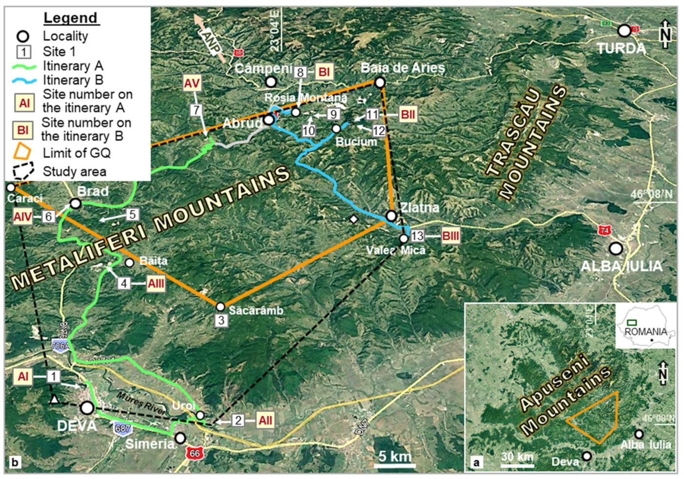
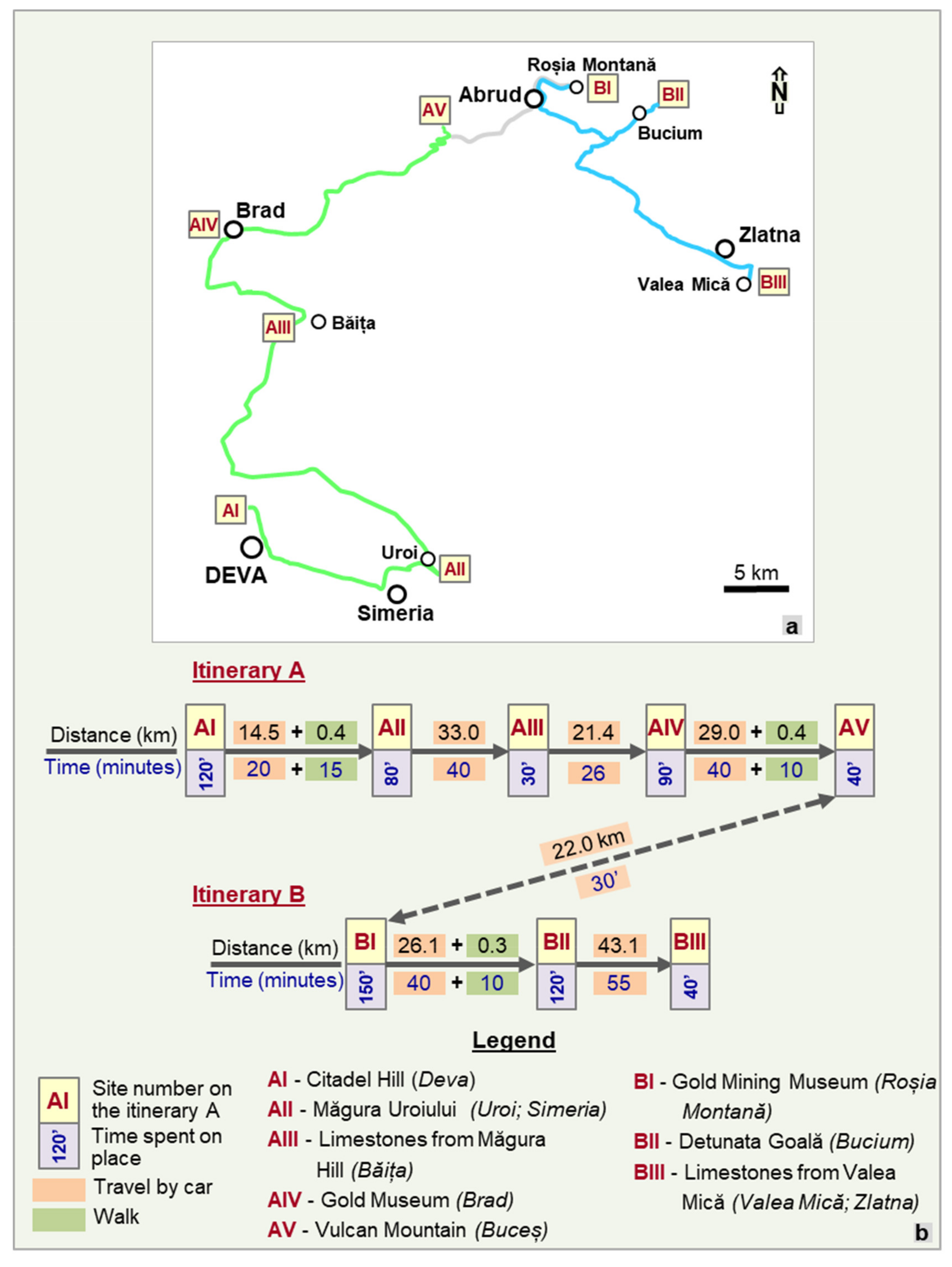
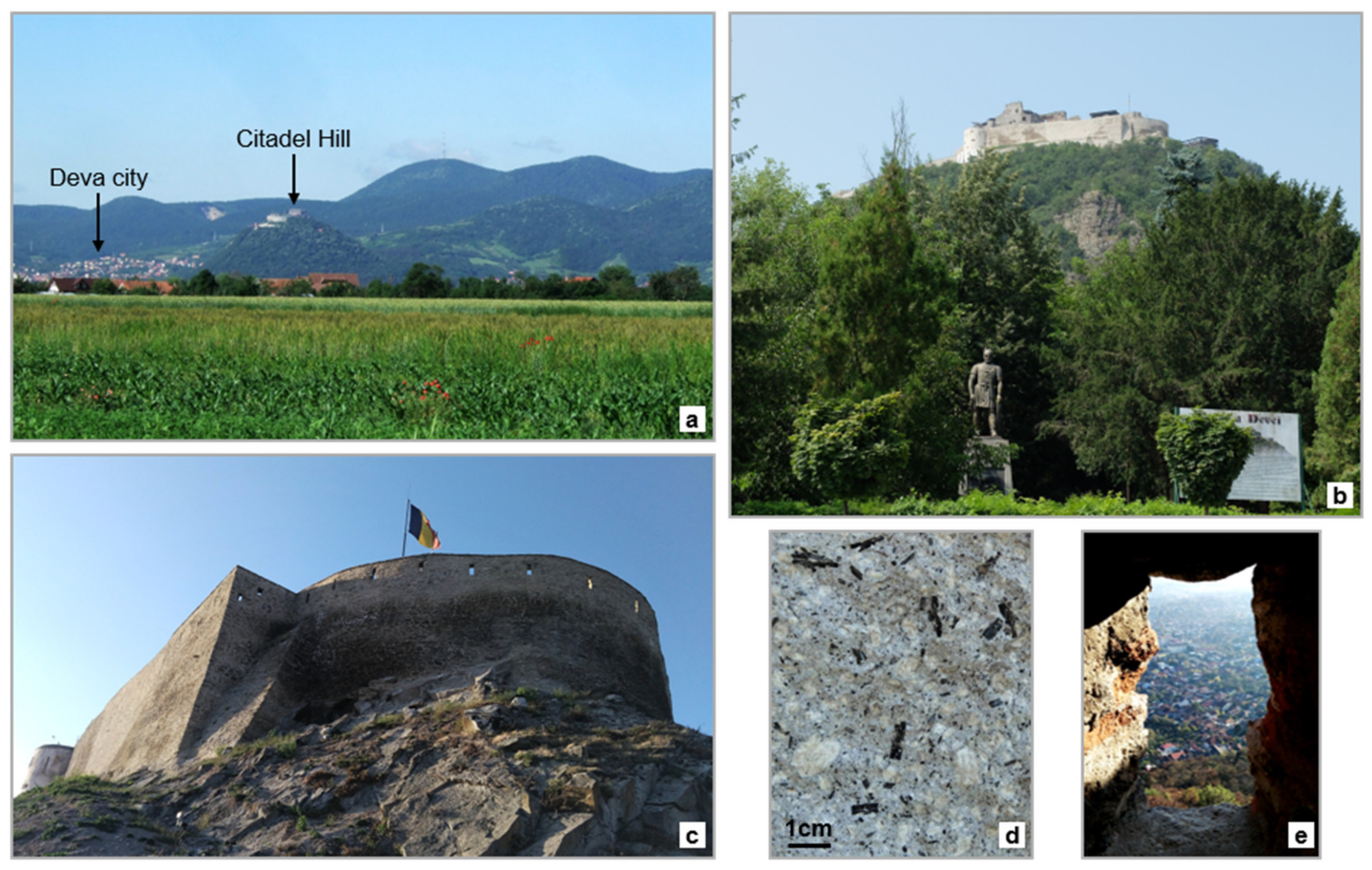
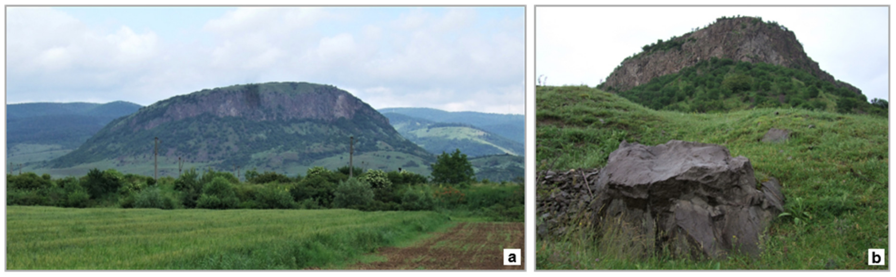
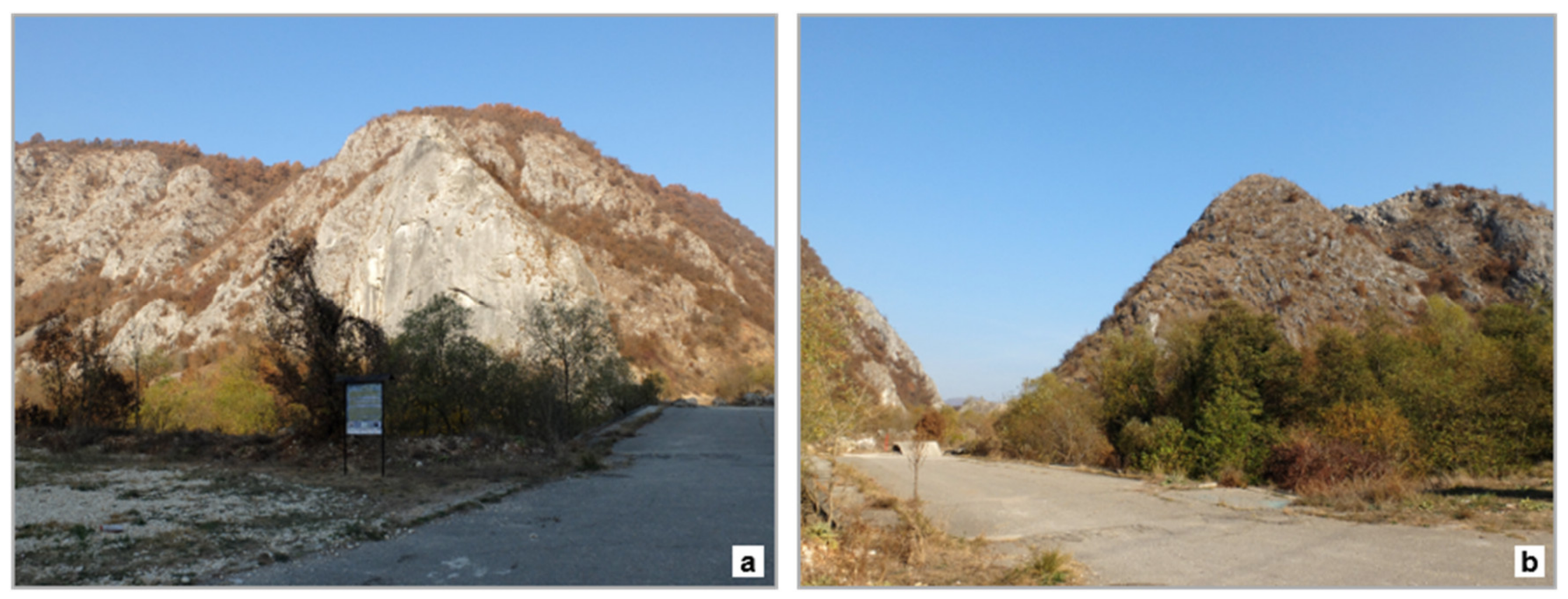
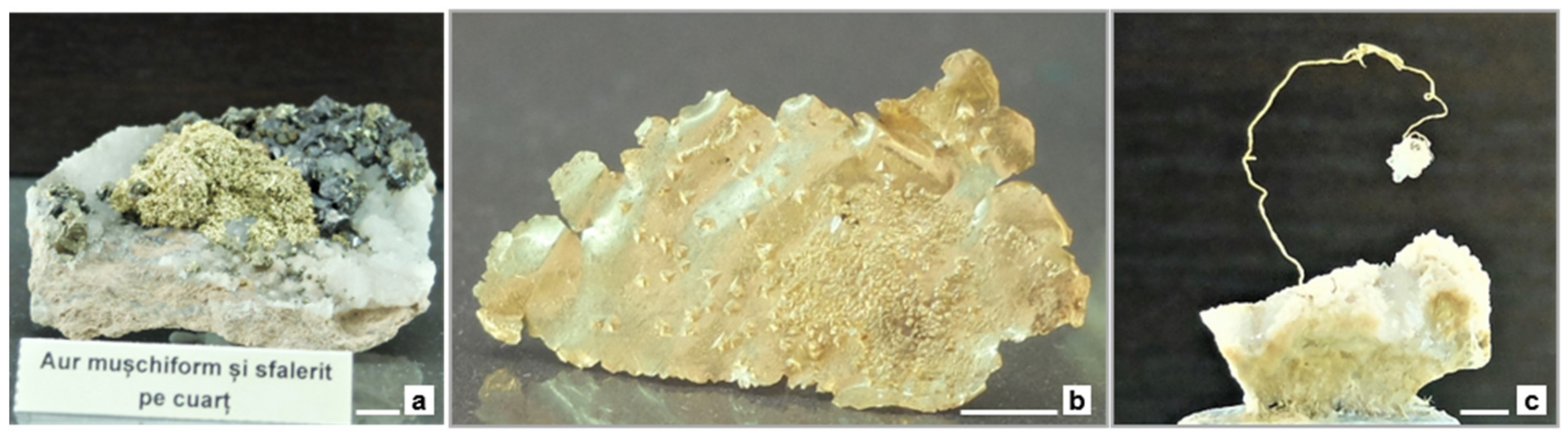
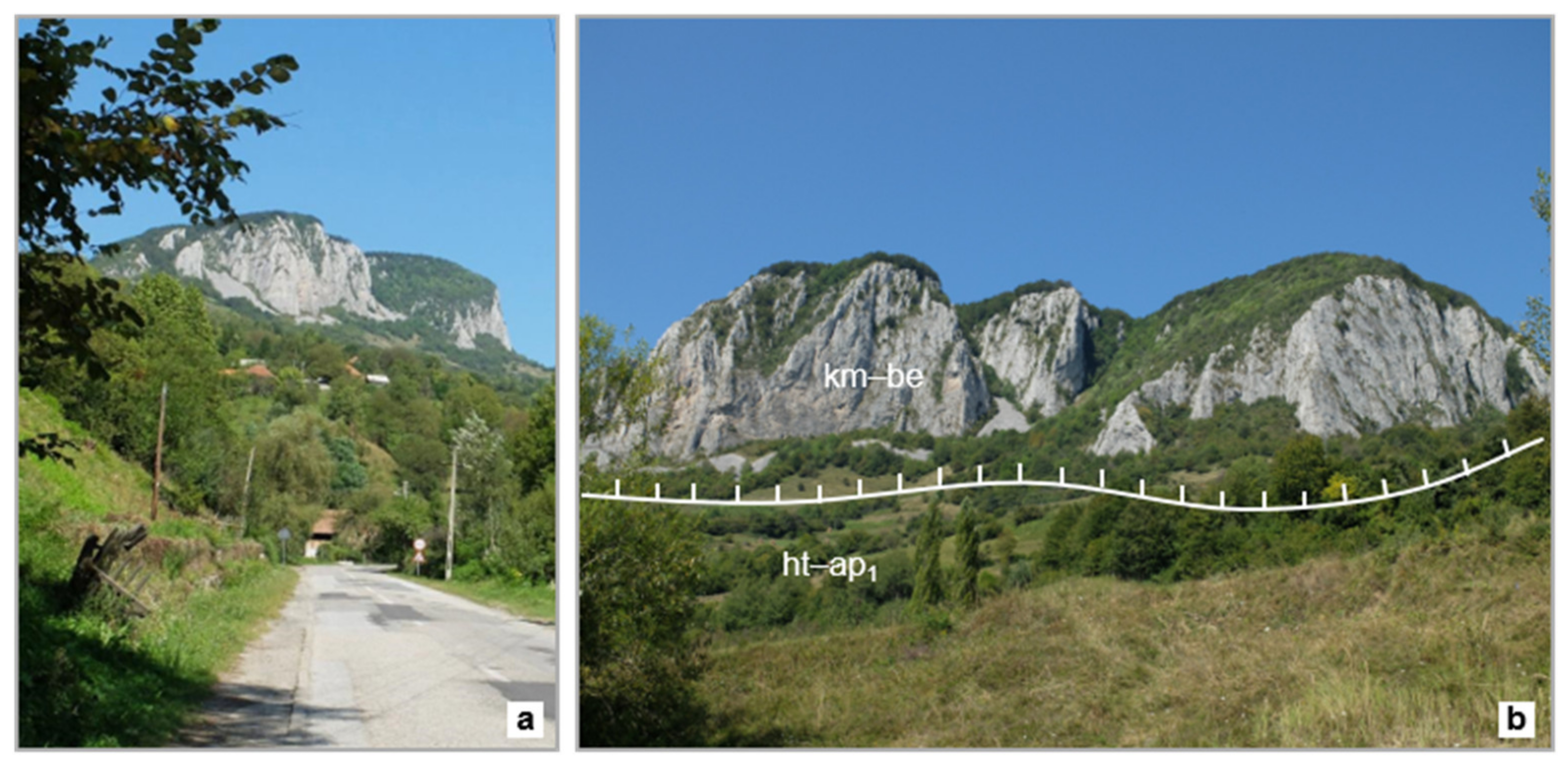
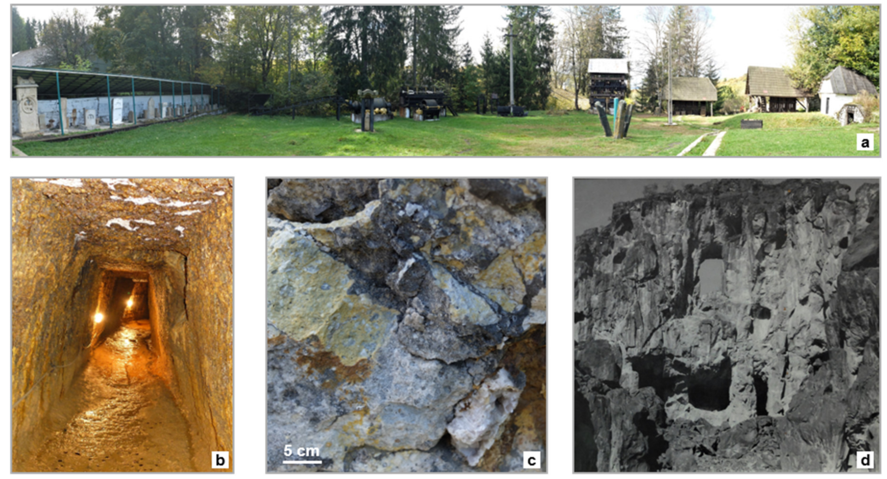
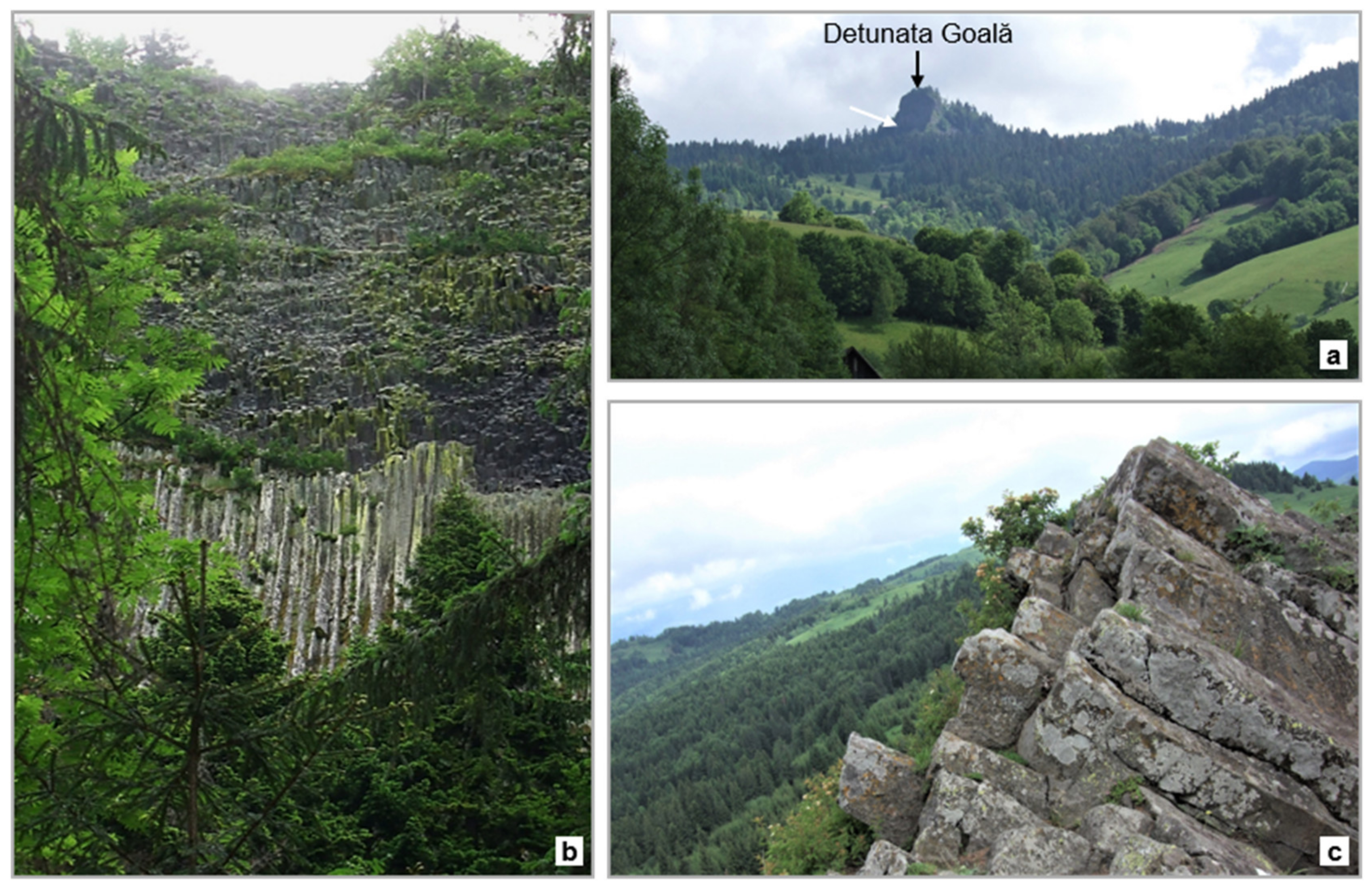
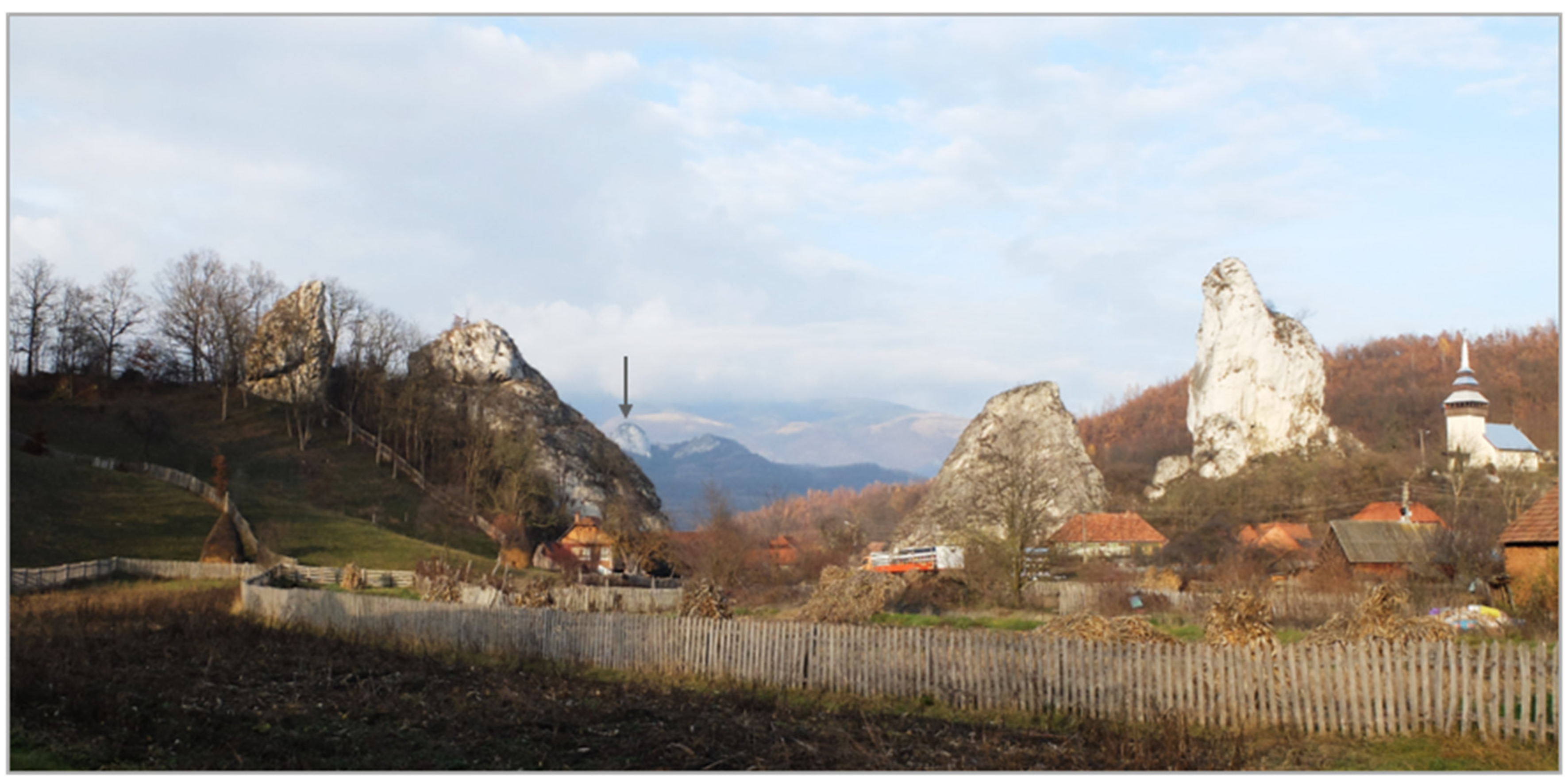
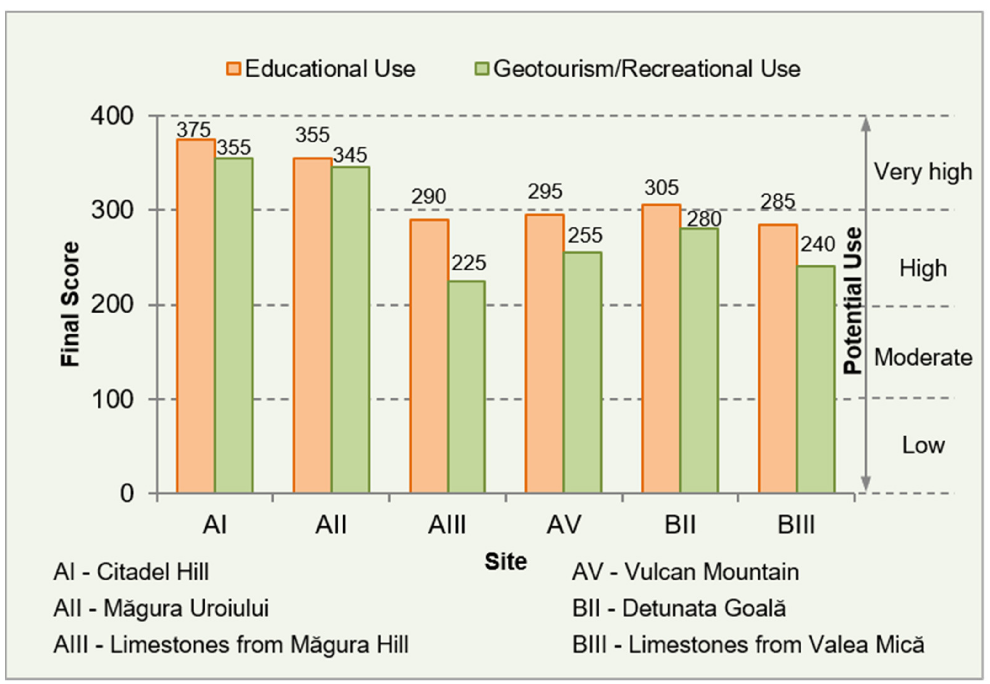
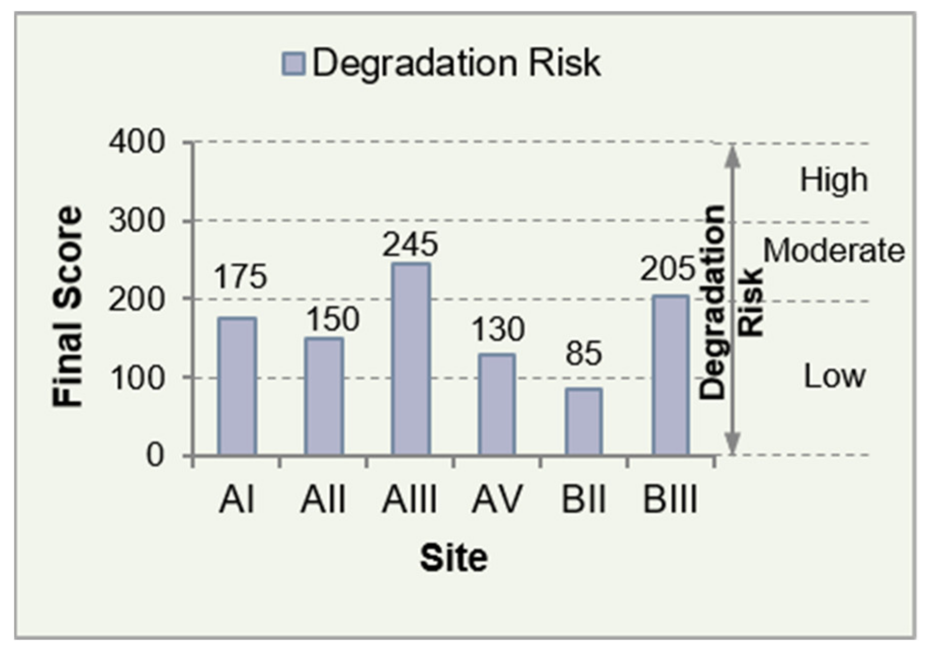
Table 1.
Inventory and characteristics of the geological and mining heritage sites in the Golden Quadrilateral (Metaliferi Mountains).
Table 1.
Inventory and characteristics of the geological and mining heritage sites in the Golden Quadrilateral (Metaliferi Mountains).
| Site No | Site Name | Locality /County * | GPS Coordinates | Main Features | Short Description | Value ** | Designation | Year |
|---|---|---|---|---|---|---|---|---|
| 1 | Dealul Cetății Deva (Citadel Hill) | Deva /HD | 45°53′21″ N 22°53′48″ E | Landscape, magmatism, petrology, panoramic view | A Miocene subvolcanic body of andesites and a 13th century fortress built at the upper part of it; Medieval architectural ensemble, archaeological site | S, E, T, A/H, C | Nature Reserve | 1954 |
| 2 | Măgura Uroiului | Uroi; Simeria; Rapoltu Mare/HD | 45°51′39″ N 23°02′39″ E | Type locality (mineralogy locality), petrology, volcanic landform | Quaternary volcanic dome of alkaline rocks (trachyandesites); type locality for two minerals; archaeological site | S, E, T, A/H | Nature Reserve | 1988 |
| 3 | Săcărâmb Village | Certejul de Sus/HD | 45°58′25″ N 23°02′12″ E | Type locality, mineralogy, ore deposit, mining heritage | Old mining locality (nearly 250 years of continuous mining activity); Neogene Au-Ag-Te epithermal deposit; type locality for eight minerals | S, E, M, C, H, T | - | - |
| 4 | Limestones from Măgura Hill | Băița /HD | 46°01′48″ N 22°52′34″ E | Stratigraphy, sedimentary processes, speleology | Late Jurassic sedimentary rocks (Tithonian reef limestones on Oxfordian–Kimmeridgian calcareous breccia); dolines and caves; cave habitations (archaeological site) | S, E, A/H, T | Nature Reserve | 1988 |
| 5 | “Roman Stairs” Mine Gallery | Ruda-Brad; Brad /HD | 46°05′36″ N 22°50′37″ E | Mining heritage, history of mining | Mining heritage from Roman period in Dacia (2nd to 3rd centuries A.D.); mining industrial heritage, archaeological site | S, E, M, A/H, C | - | - |
| 6 | Gold Museum | Brad /HD | 46°07′44″ N 22°47′28″ E | Mineralogy, metallogeny, ore deposits, history of mining | Collections: exceptional specimens of minerals and rocks (most of them from gold mines of Romania); hundreds of native gold and gold-bearing samples; mining tools; mining-related documents | S, E, M, A/H, C, T | - | - |
| 7 | Vulcan Mountain | Buceș /HD | 46°14′18″ N 22°57′44″ E | Geomorphology,stratigraphy, tectonics, paleontology | Kimmeridgian–Berriasian massive limestones on Hauterivian–Lower Aptian flysch deposits; gravitational nappe, fossils, dolines, talus deposit (see Section 4.1.1) | S, E, T | Nature Reserve | 1978 |
| 8 | Gold Mining Museum | Roșia Montană Village /AB | 46°18′15″ N 23°06′52″ E | Mining and mining industrial heritage, archaeological/historical heritage | In Roșia Montană (ancient Alburnus Maior), mining activities are known since Antiquity. Museum consists in: an underground part (Roman galleries) and an open air part (equipment for mining and ore processing, archaeological vestiges) | S, E, M, A/H, C, T | - | - |
| 9 | Piatra Corbului | Roșia Montană commune /AB | 46°17′50″ N 23°08′01″ E | Endogenous and exogenous processes | Named the Raven’s Rock (in Romanian) due to the fact that its form resembles a crow’s head, the magmatic rocks occur in the area of the Roșia Montană ore deposit | S, E, T | Natural Monument | 1999 |
| 10 | Piatra Despicată | Roșia Montană commune/AB | 46°17′51″ N 23°07′40″ E | A huge exotic block of magmatic rocks | A legend says that a giant carrying the block over the Apuseni Mts., dropped it right there, where it is now | S, T, C | Natural Monument | 1999 |
| 11 | Detunata Goală | Bucium /AB | 46°16′38″ N 23°10′53″ E | Scenic volcanic landform, history of geology | Neogene basaltic andesites occurring as spectacular columns that dominate the landscape of the area; first declared natural monument of geological interest in Romania | S, E, T, C | Natural Monument | 1938 |
| 12 | Detunata Flocoasă | Bucium /AB | 46°16′01″ N 23°12′05″ E | Volcanic processes, mineralogy, petrology | The same main features as site no. 11, but this one is more covered by vegetation | S, E, T, C | Natural Monument | 1968 |
| 13 | Limestones from Valea Mică | Valea Mică; Zlatna /AB | 46°04′47″ N 23°16′38″ E | Tectonics, stratigraphy, sedimentary klippes (olistoliths) | Imposing white block (steep cliffs) of Mesozoic sedimentary rocks detached from a carbonate platform; cave | S, E, T, C | Nature Reserve | 1994 |
Table 2.
Minerals discovered, for the first time in the word, in the area of Golden Quadrilateral. Data according to IMA (International Mineralogical Association) list of minerals [75] and literature.
Table 2.
Minerals discovered, for the first time in the word, in the area of Golden Quadrilateral. Data according to IMA (International Mineralogical Association) list of minerals [75] and literature.
| Mineral | Chemical Formula | Year * | Type Locality | County ** |
|---|---|---|---|---|
| pseudobrookite | (Fe3+2Ti)O5 | 1878 (1988 r.d.) *** | Uroi | HD |
| magnesio-fluoro- -hastingsite | NaCa2(Mg4Fe3+)(Si6Al2)O22F2 | 2005 (2012 r.d.) | Uroi | HD |
| alabandite | MnS | 1832 | Săcărâmb | HD |
| nagyágite | [Pb3(Pb,Sb)3S6](Au,Te)3 | 1845 | Săcărâmb | HD |
| petzite | Ag3AuTe2 | 1845 | Săcărâmb | HD |
| krennerite | Au3AgTe8 | 1877 | Săcărâmb | HD |
| muthmannite | AuAgTe2 | 1911 | Săcărâmb | HD |
| stützite | Ag5-xTe3 (x = 0.24 − 0.36) | 1951 (1964 r.d.) | Săcărâmb | HD |
| krautite | Mn(AsO3OH)·H2O | 1974 | Săcărâmb | HD |
| museumite | [Pb2(Pb,Sb)2S8][(Te,Au)2] | 2003 | Săcărâmb | HD |
| alburnite | Ag8GeTe2S4 | 2012 | Roșia Montană | AB |
| sylvanite | AgAuTe4 | 1835 | Baia de Arieș | AB |
| tellurium | Te | 1802 | Fața Băii | AB |
| tellurite | TeO2 | 1845 | Fața Băii | AB |
Notes: * Year of original description for minerals discovered before the establishment of IMA in 1958; year in which the mineral was approved by IMA for minerals discovered after 1958. ** County: AB—Alba, HD—Hunedoara; *** (1988 r.d.)—redefined in 1988. For location of the type localities, see Figure 1b.
Table 3.
Quantitative assessment of the geosites of the two proposed itineraries as potential sites for educational and geotourism/recreational uses (Brilha method [10,11]).
| Criteria | Itinerary A | Itinerary B | ||||||||||
|---|---|---|---|---|---|---|---|---|---|---|---|---|
| AI | AII | AIII | AV | BII | BIII | |||||||
| Criterion Score = Indicator Value × Criterion Weight | ||||||||||||
| Edu | Geot | Edu | Geot | Edu | Geot | Edu | Geot | Edu | Geot | Edu | Geot | |
| Vulnerability | 40 | 40 | 40 | 40 | 20 | 20 | 40 | 40 | 40 | 40 | 20 | 20 |
| Accesibility | 40 | 40 | 30 | 30 | 30 | 30 | 30 | 30 | 30 | 30 | 40 | 40 |
| Use limitations | 20 | 20 | 20 | 20 | 15 | 15 | 20 | 20 | 20 | 20 | 20 | 20 |
| Safety | 40 | 40 | 30 | 30 | 30 | 30 | 30 | 30 | 20 | 20 | 30 | 30 |
| Logistics | 20 | 20 | 20 | 20 | 20 | 20 | 15 | 15 | 20 | 20 | 15 | 15 |
| Density of population | 20 | 20 | 15 | 15 | 5 | 5 | 5 | 5 | 5 | 5 | 5 | 5 |
| Association with other values | 20 | 20 | 20 | 20 | 20 | 20 | 5 | 5 | 15 | 15 | 15 | 15 |
| Scenery | 20 | 60 | 20 | 60 | 5 | 15 | 15 | 45 | 15 | 45 | 5 | 15 |
| Uniqueness | 5 | 10 | 20 | 40 | 5 | 10 | 5 | 10 | 10 | 20 | 5 | 10 |
| Observation conditions | 40 | 20 | 40 | 20 | 40 | 20 | 40 | 20 | 40 | 20 | 40 | 20 |
| Didactic potential | 80 | 60 | 60 | 60 | 60 | 60 | ||||||
| Geological diversity | 30 | 40 | 40 | 30 | 30 | 30 | ||||||
| Interpretative potential | 30 | 20 | 30 | 30 | 30 | 30 | ||||||
| Economic level | 15 | 10 | 5 | 5 | 5 | 10 | ||||||
| Proximity of recreational areas | 20 | 20 | 5 | 0 | 10 | 10 | ||||||
| Final Score | 375 | 355 | 355 | 345 | 290 | 225 | 295 | 255 | 305 | 280 | 285 | 240 |
Publisher’s Note: MDPI stays neutral with regard to jurisdictional claims in published maps and institutional affiliations. |
© 2021 by the author. Licensee MDPI, Basel, Switzerland. This article is an open access article distributed under the terms and conditions of the Creative Commons Attribution (CC BY) license (https://creativecommons.org/licenses/by/4.0/).
Share and Cite
MDPI and ACS Style
Milu, V. Preliminary Assessment of the Geological and Mining Heritage of the Golden Quadrilateral (Metaliferi Mountains, Romania) as a Potential Geotourism Destination. Sustainability 2021, 13, 10114. https://doi.org/10.3390/su131810114
AMA Style
Milu V. Preliminary Assessment of the Geological and Mining Heritage of the Golden Quadrilateral (Metaliferi Mountains, Romania) as a Potential Geotourism Destination. Sustainability. 2021; 13(18):10114. https://doi.org/10.3390/su131810114
Chicago/Turabian StyleMilu, Viorica. 2021. "Preliminary Assessment of the Geological and Mining Heritage of the Golden Quadrilateral (Metaliferi Mountains, Romania) as a Potential Geotourism Destination" Sustainability 13, no. 18: 10114. https://doi.org/10.3390/su131810114
Note that from the first issue of 2016, this journal uses article numbers instead of page numbers. See further details here.