The death of North Korea's leader, Kim Jong Il, serves as a reminder that the hard-line communist country has long been in the dark — literally. A white border highlights the dark spot known as North Korea in this visualization of our planet's city lights.
This iconic "Earth at Night" picture is based on data gathered by military satellites in 1994-1995, just after Kim inherited power from his late father, Kim Il Sung. The darkness shows how much North Korea has lagged behind its neighbors — South Korea, China, Russia and Japan — in electrification and industrial development. Updates of the data sets show that there's been no change in North Korea's city-light situation between 1992 and 2009. Check out NOAA's "Science on a Sphere" webpage for more about the "Earth at Night" satellite data project.
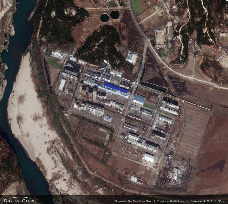
A different kind of satellite project shows where North Korea has made progress during the dark age of Kim Jong Il: For years, the Institute for Science and International Security has been using satellite imagery to document the state of North Korea's nuclear program. Pictures acquired from orbit over the past couple of years show new construction at the country's Yongbyon nuclear center.
Here's a recent picture of the Yongbyon site from DigitalGlobe, a commercial satellite imaging venture. ISIS says the blue roofs on a gas centrifuge plant and an adjoining building appear to be part of increased construction activity:

"Whatever the purpose, these activities show that more is going on at Yongbyon than commonly believed," ISIS analyst Paul Brannan wrote in his latest report. The future of North Korea's nuclear program will be a top concern for the United States and its allies as they assess Pyongyang's leadership transition — and satellites will provide the key data for that assessment.
These satellite views of North Korea serve as today's offering from the Cosmic Log Space Advent Calendar, which presents views of Earth from space every day from now until Christmas. Catch up on these previous entries from the calendar:
- The full Cosmic Log Space Advent Calendar
- Dec. 1: An ornament in outer space
- Dec. 2: The masses in Mecca
- Dec. 3: Santa's shrinking domain
- Dec. 4: The monster of Madagascar
- Dec. 5: Antarctica stripped naked
- Dec. 6: Streaking for home
- Dec. 7: Pearl Harbor from above, 1941-2011
- Dec. 8: The rise and fall of the Dead Sea
- Dec. 9: How an eclipse dims Earth
- Dec. 10: Psychedelic storm
- Dec. 11: Beauty of the Inland Sea
- Dec. 12: Drone-spotting stirs up debate
- Dec. 13: Light up your St. Lucy's Day
- Dec. 14: Satellite spots Chinese aircraft carrier
- Dec. 15: Hooray for Hollywood
- Dec. 16: Olympics under construction
- Dec. 17: Mystery in the Gobi Desert
- Dec. 18: Glow over Miami
- Hubble calendar, from The Atlantic's In Focus
- 2011 Zooniverse Advent calendar
Tip o' the Log to Ezra Klein's Wonkblog at The Washington Post and Afrikent.
Correction for 11 p.m. ET: I mistakenly referred to "Science on a Sphere" as being provided by NASA, when it's actually provided by the National Oceanic and Atmospheric Administration. Sorry about that! Must have been because the first time I saw the "Science on a Sphere" display was at NASA's Goddard Space Flight Center.
Connect with the Cosmic Log community by "liking" the log's Facebook page, following @b0yle on Twitter and adding the Cosmic Log page to your Google+ presence. You can also check out "The Case for Pluto," my book about the controversial dwarf planet and the search for new worlds.
