 |
|
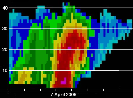
Vertical cross-sections of reflectivity (and velocity) data can be constructed from NWS Doppler radar. Forecasters "cut" a cross-sectional line through a precipitation entity or thunderstorm of interest. Software creates the chosen cross-section based on all radar elevation scans through the entity, which is then displayed for forecaster assessment. Cross-sections are extremely important in assessing the vertical structure of thunderstorms and severe weather potential. In the image of a supercell thunderstorm, a deep layer of heavy precipitation and possibly hail (red and pink colors) exists up to 30,000 ft with an echo top just over 40,000 ft. In addition, a bounded weak echo region (BWER) is present aloft between the main deep core of red color (downdraft location) and the "overhanging" red area to the right of the core, where an area of lower reflectivity values exist. A BWER indicates the location of the rotating updraft (mesocyclone) in a severe supercell. Since the updraft is displaced from the downdraft (and also due to dynamical processes in the storm), a supercell can maintain its intensity potentially for several hours. Blue colors in the upper right of the image represent light precipitation and ice crystals in the anvil of the storm downwind from the storm's core. |


 Weather Story
 Weather Map
 Local Radar
 Follow us on YouTube