

Geology of the Shenandoah National Park Region - Csmres Jmu ...
Geology of the Shenandoah National Park Region - Csmres Jmu ...
Geology of the Shenandoah National Park Region - Csmres Jmu ...

Create successful ePaper yourself
Turn your PDF publications into a flip-book with our unique Google optimized e-Paper software.
39 th Annual Virginia Geological Field Conference<br />
October 2 nd - 3 rd , 2009<br />
<strong>Geology</strong> <strong>of</strong> <strong>the</strong><br />
<strong>Shenandoah</strong> <strong>National</strong> <strong>Park</strong> <strong>Region</strong><br />
Scott Southworth<br />
U. S. Geological Survey<br />
L. Scott Eaton<br />
James Madison University<br />
Meghan H. Lamoreaux<br />
College <strong>of</strong> William & Mary<br />
William C. Burton<br />
U. S. Geological Survey<br />
1<br />
Christopher M. Bailey<br />
College <strong>of</strong> William & Mary<br />
Gregory Hancock<br />
College <strong>of</strong> William & Mary<br />
Ronald J. Litwin<br />
U. S. Geological Survey<br />
Jennifer Whitten<br />
College <strong>of</strong> William & Mary
2009<br />
VGFC<br />
81<br />
38˚ 15’ N<br />
•<br />
Trayfoot<br />
Mtn.<br />
3 •<br />
78˚ 45’ W<br />
Blue<br />
Ridge<br />
Massanutten Mountain<br />
33<br />
South Fork <strong>Shenandoah</strong> River<br />
• 4<br />
Skyline Drive<br />
Pasture Fence Mtn.<br />
Roanoke<br />
Valley & Ridge<br />
340<br />
Rocky<br />
Mtn. •<br />
5 •<br />
•<br />
Big Flat<br />
Mtn.<br />
Washington<br />
VA<br />
Piedmont D.C.<br />
• L<strong>of</strong>t Mtn.<br />
•<br />
Fox Mtn.<br />
New<br />
Market Gap<br />
•<br />
Elkton<br />
340<br />
<strong>Shenandoah</strong><br />
•<br />
Hanse<br />
Mtn.<br />
• Flattop<br />
Mtn.<br />
Swift Run •<br />
Gap<br />
2 •<br />
• 6<br />
Field Trip<br />
Stop<br />
• Hightop<br />
• Brokenback<br />
Mtn.<br />
• 7<br />
•<br />
Grindstone<br />
Mtn.<br />
Stanley<br />
Dean<br />
Mtn. •<br />
78˚ 30’ W<br />
N<br />
211<br />
Long Ridge<br />
• Lewis<br />
Mtn.<br />
Skyline Drive<br />
• Saddleback<br />
Mtn.<br />
Luray<br />
Hershberger<br />
Hill<br />
Big<br />
Meadows<br />
•7<br />
• Hazeltop<br />
Hawksbill •<br />
• 1<br />
Kirtley<br />
Mtn.<br />
Stony Man •<br />
33<br />
230<br />
Stanardsville<br />
Ruckersville<br />
Doubletop Mtn.<br />
Marys Rock •<br />
29<br />
0 5 10<br />
Thornton<br />
Gap<br />
•<br />
Old Rag<br />
Mtn.<br />
38˚ 30’ N<br />
Syria<br />
0<br />
kilometers<br />
5 10<br />
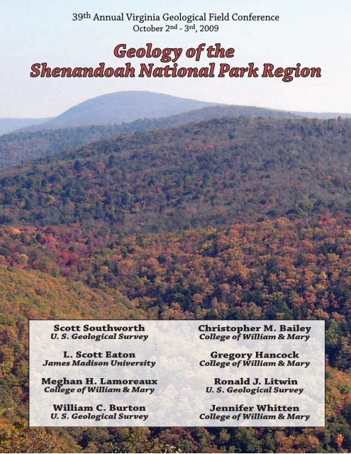
Figure 1. Shaded relief map <strong>of</strong> <strong>the</strong> <strong>Shenandoah</strong> <strong>National</strong> <strong>Park</strong> region and stop locations at <strong>the</strong> 2009 Virginia<br />
Geological Field Conference.<br />
2<br />
miles
Dedication<br />
The 39 th annual Virginia Geological Field Conference is dedicated to Tom Gathright whose work in western Virginia<br />
and <strong>Shenandoah</strong> <strong>National</strong> <strong>Park</strong> has educated and inspired many <strong>of</strong> us.<br />
Tom Gathright joined <strong>the</strong> Division <strong>of</strong> Mineral Resources in 1964. Originally a member <strong>of</strong> <strong>the</strong> Ground water<br />
Section, Tom conducted groundwater investigations in <strong>the</strong> Blue Ridge and Valley & Ridge provinces. During<br />
this time, he helped to locate and develop several major water supplies along <strong>the</strong> west flank <strong>of</strong> <strong>the</strong> Blue Ridge.<br />
Tom’s first project with <strong>the</strong> Geologic Mapping Section was to create a geologic map <strong>of</strong> <strong>Shenandoah</strong> <strong>National</strong><br />
<strong>Park</strong>. This work was published in 1976 as Bulletin 86, “<strong>Geology</strong> <strong>of</strong> <strong>the</strong> <strong>Shenandoah</strong> <strong>National</strong> <strong>Park</strong>, Virginia.”<br />
It remains one <strong>of</strong> <strong>the</strong> most popular reports related to Virginia geology. Tom subsequently completed geologic<br />
maps <strong>of</strong> ten additional 7.5-minute quadrangles and helped to compile three geologic maps <strong>of</strong> three 30- x<br />
60-minute quadrangles. As <strong>the</strong> head <strong>of</strong> <strong>the</strong> geologic mapping section, he oversaw <strong>the</strong> completion <strong>of</strong> geologic<br />
mapping <strong>of</strong> <strong>the</strong> southwest Virginia Coalfields. Tom retired in 1991, but continues to work on an occasional<br />
basis as a geologic consultant and serves as a member <strong>of</strong> Virginia’s geologic mapping advisory committee.<br />
Tom framing a photograph on a crisp morning at Rockfish Gap.<br />
photos courtesy <strong>of</strong> Elizabeth Campbell (top) and Gerry Wilkes (bottom).<br />
3
Introduction<br />
<strong>Shenandoah</strong> <strong>National</strong> <strong>Park</strong> and its magnificent Skyline Drive lie astride <strong>the</strong> Blue Ridge Mountains in northcentral<br />
Virginia. Occupying more than 800 km 2 , <strong>Shenandoah</strong> is a long and narrow park with a highly irregular<br />
boundary. Established during <strong>the</strong> Great Depression, <strong>the</strong> <strong>Park</strong> was intended to serve as a leafy refuge for<br />
urbanites in eastern North America. Created from a patchwork <strong>of</strong> privately owned farms, orchards, and home<br />
sites, <strong>the</strong> <strong>Park</strong> has been reforested in <strong>the</strong> past 80 years with much <strong>of</strong> <strong>the</strong> region returned to a wilderness<br />
state. In modern times, <strong>the</strong> <strong>Park</strong> welcomes over two million visitors per year.<br />
The Blue Ridge Mountains in <strong>Shenandoah</strong> <strong>National</strong> <strong>Park</strong> form a distinctive highland that rises to elevations<br />
above 1,200 meters (~4,000’) with local topographic relief exceeding 900 meters (~3,000’). The crest <strong>of</strong> <strong>the</strong><br />
range forms a drainage divide separating <strong>the</strong> <strong>Shenandoah</strong> (Potomac) River drainage to <strong>the</strong> west, in <strong>the</strong> Great<br />
Valley subprovince <strong>of</strong> <strong>the</strong> Valley & Ridge, from sou<strong>the</strong>ast-flowing streams <strong>of</strong> <strong>the</strong> James and Rappahannock<br />
river systems coursing into <strong>the</strong> foothills region <strong>of</strong> <strong>the</strong> Piedmont physiographic province (Fig. 1).<br />
Although a cloak <strong>of</strong> forest and mantle <strong>of</strong> soil commonly obscures <strong>the</strong> underlying bedrock, <strong>Shenandoah</strong>’s<br />
topography is dictated by its geology. Rocks exposed in <strong>the</strong> Blue Ridge Mountains are among <strong>the</strong> oldest<br />
in Virginia and bear witness to more than a billion years <strong>of</strong> magmatism, sedimentation, sea level oscillation,<br />
climate change, tectonic activity, and erosion. Bedrock includes a suite <strong>of</strong> Grenvillian basement rocks,<br />
metamorphosed Neoproterozoic sedimentary and volcanic rocks, and early Cambrian siliciclastic rocks.<br />
The <strong>Park</strong> is situated along <strong>the</strong> western margin <strong>of</strong> <strong>the</strong> Blue Ridge anticlinorium, a regional-scale Paleozoic<br />
structure developed at <strong>the</strong> hinterland edge <strong>of</strong> <strong>the</strong> Appalachian fold and thrust belt. The Blue Ridge highlands<br />
are <strong>the</strong> product <strong>of</strong> differential erosion in <strong>the</strong> Cenozoic, but post-Paleozoic tectonic activity has influenced<br />
<strong>the</strong> character <strong>of</strong> <strong>the</strong> Blue Ridge landscape in discernible ways. Quaternary surficial deposits are common<br />
throughout <strong>the</strong> <strong>Park</strong>, providing a record <strong>of</strong> past climate regimes as well as active processes shaping <strong>the</strong><br />
modern landscape.<br />
Aspects <strong>of</strong> <strong>the</strong> <strong>Park</strong>’s geology have been studied since <strong>the</strong> 1930’s (Furcron, 1934; Jonas and Stose, 1939;<br />
King, 1950) and many <strong>of</strong> <strong>the</strong> counties that encompass <strong>the</strong> <strong>Park</strong> were mapped after World War II (Rockingham-<br />
Brent, 1960; Albemarle- Nelson, 1962; Greene and Madison- Allen, 1963; Page- Allen, 1967). The first<br />
comprehensive treatment <strong>of</strong> <strong>Shenandoah</strong>’s geology was undertaken by <strong>the</strong> Virginia Division <strong>of</strong> Mineral<br />
Resources in <strong>the</strong> late 1960s and culminated in <strong>the</strong> 1976 publication and geologic map (1:62,500 scale) by<br />
Tom Gathright. Gathright’s seminal work summarized many <strong>of</strong> <strong>the</strong> earlier studies and provided a unifying<br />
framework <strong>of</strong> <strong>the</strong> <strong>Park</strong>’s geology that is still informative in <strong>the</strong> 21 st century. The hydrogeologic setting <strong>of</strong> <strong>the</strong><br />
<strong>Park</strong> is discussed by DeKay (1972).<br />
Robert Badger’s Roadside <strong>Geology</strong> <strong>of</strong> <strong>the</strong> Skyline Drive (1999) is a well-illustrated guide aimed at a broad<br />
audience. Tollo and o<strong>the</strong>rs (2004), Eaton and o<strong>the</strong>rs (2004), and Bailey and o<strong>the</strong>rs (2006) provide technical<br />
field guides with stops in and near <strong>the</strong> <strong>Park</strong>. Web resources illustrating <strong>the</strong> geology <strong>of</strong> <strong>Shenandoah</strong> <strong>National</strong><br />
<strong>Park</strong> include: William & Mary’s <strong>Geology</strong> <strong>of</strong> Virginia/Google Earth site (http://web.wm.edu/geology/virginia/<br />
ge.php), James Madison’s <strong>Geology</strong> <strong>of</strong> Virginia site, (http://csmres.jmu.edu/geollab/vageol/vahist/) and Callan<br />
Bentley’s (Nor<strong>the</strong>rn Virginia Community College) <strong>Geology</strong> <strong>of</strong> <strong>Shenandoah</strong> <strong>National</strong> <strong>Park</strong> site (http://www.<br />
nvcc.edu/home/cbentley/gol_135/shenandoah/index.htm).<br />
In <strong>the</strong> past fifteen years, a multitude <strong>of</strong> studies focusing on <strong>the</strong> geology <strong>of</strong> <strong>Shenandoah</strong> <strong>National</strong> <strong>Park</strong> have<br />
contributed new insights about 1) <strong>the</strong> complexity and chronology <strong>of</strong> <strong>the</strong> basement, 2) <strong>the</strong> structural geometry<br />
and deformation history <strong>of</strong> <strong>the</strong> region, and 3) Quaternary surficial processes and <strong>the</strong>ir efficacy. Nineteen 7.5’<br />
quadrangles in and around <strong>Shenandoah</strong> <strong>National</strong> <strong>Park</strong> have been mapped (or remapped) at 1:24,000 scale<br />
in <strong>the</strong> last decade (Fig. 2). A new 1:100,000 scale geologic map <strong>of</strong> <strong>the</strong> <strong>Shenandoah</strong> <strong>National</strong> <strong>Park</strong> region and<br />
an accompanying report, compiling much <strong>of</strong> this research, was just published by <strong>the</strong> U. S. Geological Survey<br />
(Southworth and o<strong>the</strong>rs, 2009; online at http://pubs.er.usgs.gov/usgspubs/<strong>of</strong>r/<strong>of</strong>r20091153).<br />
4
The 2009 Virginia Geological Field Conference will highlight new research, visiting exposures along and<br />
near <strong>the</strong> Skyline Drive. The trip will be broad, encompassing bedrock and structural geology as well as<br />
surficial geology and rates <strong>of</strong> erosion at local and regional scales. <strong>Shenandoah</strong> <strong>National</strong> <strong>Park</strong> is too vast for<br />
a single day traverse; thus <strong>the</strong> Conference will focus on <strong>the</strong> geology between Big Meadows (milepost 51) and<br />
Blackrock Summit (milepost 85) in <strong>the</strong> central and sou<strong>the</strong>rn part <strong>of</strong> <strong>the</strong> <strong>Park</strong>. In addition to emphasizing new<br />
findings in <strong>Shenandoah</strong> we hope this trip will foster discussion about unanswered aspects about Blue Ridge<br />
geology and encourage future research in <strong>the</strong> <strong>Park</strong>.<br />
Weyers Cave<br />
38˚00’ N<br />
79˚00’ W<br />
Harrisonburg<br />
Gathright<br />
and o<strong>the</strong>rs,<br />
1986<br />
Fort<br />
Defiance<br />
Gathright<br />
and o<strong>the</strong>rs,<br />
1978<br />
Waynesboro<br />
West<br />
Gathright<br />
and o<strong>the</strong>rs,<br />
1977<br />
38˚30’ N<br />
Grottoes<br />
Gathright<br />
and o<strong>the</strong>rs,<br />
1978<br />
Crimora<br />
Gathright<br />
and o<strong>the</strong>rs,<br />
1978<br />
Waynesboro<br />
East<br />
Gathright<br />
and o<strong>the</strong>rs,<br />
1977<br />
Tenth<br />
Legion<br />
Whitmeyer<br />
and Heller<br />
Elkton West<br />
Heller<br />
McGaheysville<br />
Browns<br />
Cove<br />
Lamoreaux<br />
and o<strong>the</strong>rs,<br />
2009<br />
Crozet<br />
Lederer<br />
and o<strong>the</strong>rs,<br />
2009<br />
Edinburg<br />
Hamburg<br />
Stanley<br />
Whitmeyer<br />
and o<strong>the</strong>rs<br />
Elkton East Fletcher<br />
Swift Run<br />
Gap<br />
Bailey<br />
and o<strong>the</strong>rs,<br />
2009<br />
Free<br />
Union<br />
Southworth<br />
and Bailey<br />
Charlottesville<br />
West<br />
Big Meadows<br />
Whitmeyer<br />
and o<strong>the</strong>rs<br />
Tollo and<br />
o<strong>the</strong>rs<br />
Tollo and<br />
o<strong>the</strong>rs, 2004<br />
Stanardsville<br />
Burton<br />
and Bailey,<br />
2009<br />
Earlysville<br />
Figure 2. Index map <strong>of</strong> 7.5 minute quadrangles surrounding <strong>Shenandoah</strong> <strong>National</strong> <strong>Park</strong>. Authors noted inside<br />
quadrangles mapped at 1:24,000 scale. Grey shading indicates recent work.<br />
5<br />
Strasburg<br />
Rader and<br />
Biggs, 1976<br />
Rileyville Bentonville<br />
Southworth<br />
and<br />
Tollo, 2006<br />
Luray Thornton<br />
Gap<br />
Tollo and<br />
o<strong>the</strong>rs, 2004<br />
Old Rag<br />
Mountain<br />
Tollo and<br />
o<strong>the</strong>rs, 2004<br />
Madison<br />
Bailey and<br />
o<strong>the</strong>rs, 2003<br />
Rochelle<br />
Bailey<br />
Front Royal<br />
Rader and<br />
Biggs, 1975<br />
Washington<br />
Tollo and<br />
o<strong>the</strong>rs, 2006<br />
Washington<br />
Tollo and<br />
o<strong>the</strong>rs, 2006<br />
Woodville<br />
Tollo and<br />
Bailey<br />
Brightwood<br />
Explanation<br />
Linden<br />
Lukert and<br />
Nichols,<br />
1976<br />
Flint Hill<br />
Lukert and<br />
Nichols,<br />
1976<br />
Massies<br />
Corner<br />
Lukert and<br />
Halladay,<br />
1980<br />
<strong>Shenandoah</strong> <strong>National</strong> <strong>Park</strong><br />
Boundary<br />
0 1.5 3 6 9 12 Miles<br />
78˚00’ W<br />
39˚00’ N<br />
Castleton<br />
Tollo and Lowe, 1994<br />
Bailey and o<strong>the</strong>rs, 2007
Bedrock <strong>Geology</strong><br />
Stratigraphy<br />
<strong>Shenandoah</strong> <strong>National</strong> <strong>Park</strong> is underlain by three major geologic units: 1) Mesoproterozoic gneisses and<br />
granitoids that comprise <strong>the</strong> basement, 2) Neoproterozoic metasedimentary and metavolcanic rocks <strong>of</strong> <strong>the</strong><br />
Swift Run and Catoctin formations, and 3) siliciclastic rocks <strong>of</strong> <strong>the</strong> Early Cambrian Chilhowee Group (Figs.<br />
3 and 4). Basement rocks crop out in <strong>the</strong> eastern Blue Ridge Mountains and <strong>the</strong> adjoining foothills, but also<br />
underlie peaks such as Old Rag Mountain, Mary’s Rock, and Roundtop. The Catoctin Formation forms much<br />
<strong>of</strong> <strong>the</strong> Blue Ridge’s high crest including Hawksbill, Stony Man, Mount Marshall, and Hightop. The Chilhowee<br />
Group, exposed in <strong>the</strong> western Blue Ridge, underlies steep mountains and ridges mantled with thin soil and<br />
abundant talus such as Grindstone, Rocky, Trayfoot, and Turk mountains.<br />
Basement rocks include granitoid gneisses and granitoids formed during <strong>the</strong> Grenville orogeny between 1.2<br />
and 1.0 Ga (Fig. 3). Prior to <strong>the</strong> 1980s rock units in <strong>the</strong> Blue Ridge basement were commonly mapped as<br />
formations and Gathright (1976) mapped two basement units, <strong>the</strong> Pedlar Formation and <strong>the</strong> Old Rag Granite,<br />
in <strong>the</strong> <strong>Park</strong>. Most technical studies published in <strong>the</strong> past two decades (Rader and Evans, 1993; Southworth<br />
and o<strong>the</strong>rs, 2000; Bailey and o<strong>the</strong>rs, 2003; Tollo and o<strong>the</strong>rs, 2004b; Southworth and o<strong>the</strong>rs, 2009) avoid<br />
using <strong>the</strong> formation terminology; ra<strong>the</strong>r Mesoproterozoic basement units are distinguished based on rock<br />
type, cross cutting relations, geochemistry, and geochronology. Many general interest publications and<br />
websites continue to use <strong>the</strong> formational lexicon, this is unfortunate because <strong>the</strong> rich geologic history <strong>of</strong> <strong>the</strong><br />
basement is diluted (or worse still, misunderstood) using archaic formation names. For instance, recent<br />
mapping and geochronology in <strong>Shenandoah</strong> <strong>National</strong> <strong>Park</strong> demonstrates that <strong>the</strong> Pedlar Formation contains<br />
over 12 different units that that vary in age by ~150 million years (Southworth and o<strong>the</strong>rs, 2009).<br />
Modern U-Pb zircon geochronology reveals that <strong>the</strong> basement complex is comprised <strong>of</strong> three temporally<br />
distinct groups <strong>of</strong> igneous rocks emplaced over a 150 million year interval in <strong>the</strong> Mesoproterozoic (Fig.<br />
3) (Aleinik<strong>of</strong>f and o<strong>the</strong>rs, 2000; Tollo and o<strong>the</strong>rs, 2004b; Southworth and o<strong>the</strong>rs, 2009). The oldest group<br />
crystallized between 1,190 and 1,150 Ma and are granitoid gneisses with a compositional layering that<br />
developed under high-grade conditions. A volumetrically minor group <strong>of</strong> orthopyroxene-bearing granites<br />
crystallized between 1,120 and 1,110 Ma. The youngest group <strong>of</strong> granitoids was emplaced between 1,090<br />
and 1,020 Ma. Both <strong>the</strong> older and younger groups are chemically diverse and include pyroxene-bearing<br />
charnockitic rocks and alkali feldspar leucogranitoids. Tollo and o<strong>the</strong>rs (2004) note that <strong>the</strong> basement suite<br />
was derived from melting <strong>of</strong> lower crustal sources in an intraplate setting.<br />
The Blue Ridge basement is almost entirely <strong>of</strong> igneous origin (orthogneisses), however recent mapping has<br />
identified small (
Recent mapping in <strong>the</strong> nor<strong>the</strong>astern part <strong>of</strong> <strong>the</strong> <strong>Park</strong> reveals thin, discontinuous layers <strong>of</strong> felsic volcanic rock<br />
unconformably overlie <strong>the</strong> Mesoproterozoic basement and beneath <strong>the</strong> Catoctin Formation that yield U-Pb<br />
zircon ages <strong>of</strong> 720 to 710 Ma (Southworth and o<strong>the</strong>rs, 2009).<br />
A late Neoproterozoic cover sequence <strong>of</strong> metasedimentary and metavolcanic rocks unconformably overlie<br />
<strong>the</strong> basement complex in <strong>the</strong> <strong>Shenandoah</strong> <strong>National</strong> <strong>Park</strong> region (Fig. 3). The Swift Run Formation is a<br />
heterogeneous clastic unit <strong>of</strong> highly variable thickness (absent to ~300 m) that crops out below metabasalts<br />
<strong>of</strong> <strong>the</strong> Catoctin Formation and to <strong>the</strong> east <strong>of</strong> <strong>the</strong> <strong>Park</strong> in outliers surrounded by basement (Gattuso and<br />
o<strong>the</strong>rs, 2009). Common rock types include arkosic phyllite, meta-arkose, phyllite, laminated metasiltstone,<br />
and pebble to cobble metaconglomerate. Locally, compositionally mature, cross-bedded, quartz-rich<br />
metasandstone crops out. Gathright (1976) and Schwab (1986) interpret <strong>the</strong> Swift Run Formation to be a<br />
non-marine unit deposited in alluvial fan, floodplain, and lacustrine environments. A number <strong>of</strong> early workers<br />
report tuffaceous rocks from <strong>the</strong> Swift Run Formation, but recent research indicates <strong>the</strong>se are primarily<br />
fine-grained metasedimentary rocks. Contemporaneous normal faulting likely influenced <strong>the</strong> deposition <strong>of</strong><br />
Swift Run sediments in <strong>the</strong> outliers (Forte and o<strong>the</strong>rs, 2005; Gattuso and o<strong>the</strong>rs, 2009). At a number <strong>of</strong><br />
locations clastic rocks are interlayered with metabasaltic greenstone, a geometry consistent with a coeval<br />
relationship between <strong>the</strong> Swift Run Formation and <strong>the</strong> lower Catoctin Formation (King, 1950; Gattuso and<br />
o<strong>the</strong>rs, 2009).<br />
The Catoctin Formation forms an extensive unit in <strong>Shenandoah</strong> <strong>National</strong> <strong>Park</strong> and is characterized by<br />
metabasaltic greenstone with thin layers <strong>of</strong> meta-arkose, phyllite, and epiclastic breccia. Catoctin basalts<br />
were extruded over a large region (>4000 km 2 ) and generated from mantle-derived tholeiitic magmas (Badger<br />
and Sinha, 2004). In <strong>the</strong> <strong>Park</strong>, basalts extruded primarily as subaerial flows, evidenced by abundant columnar<br />
joints and flow-top breccias (Reed, 1955, 1969). In <strong>the</strong> central and nor<strong>the</strong>rn part <strong>of</strong> <strong>the</strong> <strong>Park</strong>, nine to sixteen<br />
individual flows occur (Reed, 1955; Gathright, 1976; Badger, 1992). The Catoctin Formation is upwards<br />
<strong>of</strong> 700 meters thick in <strong>the</strong> <strong>Park</strong> and thins towards <strong>the</strong> west and southwest. Metadiabase dikes <strong>of</strong> similar<br />
composition to Catoctin metabasalts intrude <strong>the</strong> basement complex (as well as older Neoproterozoic rocks)<br />
and are likely feeder dikes for <strong>the</strong> overlying Catoctin lava flows. Dikes range from 0.5 to 5 m in thickness and<br />
are most common in <strong>the</strong> nor<strong>the</strong>rn and central part <strong>of</strong> <strong>the</strong> <strong>Park</strong>.<br />
Badger and Sinha (1988) report a Rb-Sr isochron age <strong>of</strong> 570±36 Ma from exposures just south <strong>of</strong> <strong>Shenandoah</strong><br />
<strong>National</strong> <strong>Park</strong>. Zircons from metarhyolite tuffs and dikes in <strong>the</strong> Catoctin Formation, exposed to <strong>the</strong> north<br />
<strong>of</strong> <strong>the</strong> <strong>Park</strong>, yield U-Pb ages between 570 and 550 Ma (Aleinik<strong>of</strong>f and o<strong>the</strong>rs, 1995). Collectively, <strong>the</strong><br />
geochronologic data suggest that Catoctin volcanism lasted between 15 and 20 million years and occurred<br />
during <strong>the</strong> Ediacaran period in <strong>the</strong> late Neoproterozoic. Paleomagnetic data from <strong>the</strong> Catoctin Formation<br />
are complex, but broadly compatible with a high sou<strong>the</strong>rly latitude (60˚ S) for <strong>the</strong> Virginia Blue Ridge during<br />
extrusion (Meert and o<strong>the</strong>rs, 1994).<br />
The siliciclastic Chilhowee Group overlies <strong>the</strong> Catoctin Formation. In <strong>Shenandoah</strong> <strong>National</strong> <strong>Park</strong>, <strong>the</strong><br />
Chilhowee Group includes <strong>the</strong> Weverton, Harpers, and Antietam formations and ranges from 500 to 800<br />
meters in aggregate thickness (Fig. 3). Gathright’s (1976) nomenclature for <strong>the</strong> Chilhowee Group includes<br />
<strong>the</strong> Weverton, Hampton (Harpers), and Erwin (Antietam) formations. Weverton, Harpers, and Antietam are<br />
units whose type locations occur along <strong>the</strong> Potomac River approximately 125 km to <strong>the</strong> nor<strong>the</strong>ast, whereas<br />
<strong>the</strong> Hampton and Erwin type locations are located nor<strong>the</strong>astern Tennessee. The contact between <strong>the</strong><br />
underlying Catoctin metabasalts and <strong>the</strong> overlying Chilhowee Group has traditionally been interpreted as<br />
an unconformity, but its significance remains uncertain (King, 1950; Gathright, 1976; Southworth and o<strong>the</strong>rs,<br />
2007a).<br />
The Weverton Formation includes quartz metasandstone, granule to pebbly metaconglomerate, laminated<br />
metasiltstone, and quartzose phyllite. The Harpers Formation, in <strong>Shenandoah</strong> <strong>National</strong> <strong>Park</strong>, is dominated<br />
by green to gray phyllite and thinly bedded metasandstone. Less common rock types include well-cemented<br />
quartz arenite and ferrigunous metasandstone. Trace fossils (Skolithos and burrowed beds) are rare, but<br />
7
do occur in <strong>the</strong> upper part <strong>of</strong> <strong>the</strong> Harpers Formation. The Antietam Formation consists <strong>of</strong> distinctive wellcemented<br />
quartz arenite, with abundant Skolithos, and laminated metasiltstone. Collectively, <strong>the</strong> Chilhowee<br />
Group records a fluvial to shallow-marine transgressive sequence (2 nd -supersequence) (Simpson and<br />
Eriksson, 1990; Read and Eriksson, in press). Skolithos is <strong>the</strong> only well documented fossil in <strong>the</strong> Chilhowee<br />
Group from <strong>the</strong> <strong>Shenandoah</strong> <strong>National</strong> <strong>Park</strong> region, but along strike to <strong>the</strong> southwest, Rusophycus occurs<br />
near <strong>the</strong> base and Olenellus trilobites near <strong>the</strong> top, bracketing <strong>the</strong> age <strong>of</strong> <strong>the</strong> Chilhowee Group between <strong>the</strong><br />
earliest Cambrian and early Middle Cambrian (
cover rocks are typically asymmetric northwest-verging structures. Axial planar foliation (cleavage) is well<br />
developed in fine-grained rocks and dips gently to moderately sou<strong>the</strong>ast.<br />
Mylonitic rocks occur in anastomosing zones, up to a kilometer thick, that cut basement rocks along <strong>the</strong> eastern<br />
margin <strong>of</strong> <strong>the</strong> <strong>Park</strong> (Figs. 4 and 5). Mylonite zones in <strong>the</strong> <strong>Park</strong> were first recognized by Gathright (1976) and<br />
aspects <strong>of</strong> <strong>the</strong>se rocks have been discussed by Mitra (1977), Bailey and Simpson (1993), and Bailey and<br />
o<strong>the</strong>rs (2002). Asymmetric structures consistently record a top-to-<strong>the</strong>-northwest sense <strong>of</strong> shear (i.e. hanging<br />
wall up movement). The reverse displacement across Blue Ridge high-strain zones accommodated crustal<br />
contraction enabling <strong>the</strong> relatively stiff basement complex to shorten while cover rocks were folded.<br />
A distinctive coarse foliation or compositional banding is developed in <strong>the</strong> older Mesoproterozoic basement<br />
units (Groups 1 and 2, >1,150 Ma) and defined by aligned feldspars and quartz aggregates that formed at<br />
upper amphibolite- to granulite-facies conditions. Younger Mesoproterozoic basement units (Group 3, 80°). Transverse faults cut previously folded contacts and<br />
<strong>the</strong> apparent strike-slip <strong>of</strong>fset in map view is accomplished by dip-slip movement with maximum displacements<br />
<strong>of</strong> ~100 m. A number <strong>of</strong> transverse faults, including <strong>the</strong> recently recognized Simmons Gap and Sandy Bottom<br />
faults in <strong>Shenandoah</strong> <strong>National</strong> <strong>Park</strong>, correspond to well-developed topographic lineaments (Fig. 4; Bailey<br />
and o<strong>the</strong>rs, 2009).<br />
North-northwest striking transverse faults and extension fractures are subparallel to a regional suite <strong>of</strong> Jurassic<br />
diabase dikes. Bailey and o<strong>the</strong>rs (2006) interpreted many transverse faults in <strong>Shenandoah</strong> <strong>National</strong> <strong>Park</strong><br />
as Jurassic structures noting that <strong>the</strong>se faults record minor east-nor<strong>the</strong>ast directed extension and possibly<br />
developed in a transtensional stress regime. Wieczorek and o<strong>the</strong>rs (2004) used LIDAR imagery to identify a<br />
9
topographic lineament, which <strong>the</strong>y interpret as a north-northwest-striking fault (Harriston fault) near Grottoes<br />
and suggested this structure could have experienced Quaternary slip. Fur<strong>the</strong>r research is required to evaluate<br />
<strong>the</strong> possibility <strong>of</strong> neotectonic activity along transverse faults. Many transverse faults are zones <strong>of</strong> structural<br />
weakness and strongly influenced <strong>the</strong> topographic character <strong>of</strong> <strong>the</strong> Blue Ridge Mountains; Simmons, Powell,<br />
Smith Roach, and Swift Run gaps are all located on transverse faults.<br />
Tectonic History<br />
Rocks and structures exposed in <strong>Shenandoah</strong> <strong>National</strong> <strong>Park</strong> formed in response to tectonic processes<br />
associated with <strong>the</strong> opening <strong>of</strong> ocean basins and <strong>the</strong> collision <strong>of</strong> continents throughout <strong>the</strong> past 1.2 billion<br />
years. Major tectonic events include <strong>the</strong> Mesoproterozoic Grenvillian orogen, Neoproterozoic Iapetan rifting,<br />
multiple episodes <strong>of</strong> Paleozoic collision, and Mesozoic crustal extension (Fig. 6).<br />
Mesoproterozoic granitoids and gneisses formed in <strong>the</strong> middle and lower crust along <strong>the</strong> margin <strong>of</strong> Laurentia<br />
during <strong>the</strong> long-lived Grenvillian orogeny that culminated in <strong>the</strong> amalgamation <strong>of</strong> <strong>the</strong> Rodinian supercontinent<br />
by 1,000 Ma. Older basement granitoids were emplaced during a magmatic interval 30 to 40 My in duration<br />
(1,180 – 1,140 Ma). A high-grade deformation event transformed <strong>the</strong>se rocs into granitoid gneisses prior<br />
to <strong>the</strong> intrusion <strong>of</strong> <strong>the</strong> youngest plutonic suite by 1,080 Ma. The older deformation event is characterized by<br />
many northwest to east-west trending structures, but <strong>the</strong> kinematics <strong>of</strong> this event remain poorly understood.<br />
Lead isotopes in central and sou<strong>the</strong>rn Appalachian basement massifs are distinctly different from o<strong>the</strong>r<br />
Laurentian Grenvillian provinces implying that Blue Ridge basement is not “native crust”, but ra<strong>the</strong>r was<br />
accreted to Laurentia during this long-lived orogeny.<br />
The small exposures <strong>of</strong> post-1,000 Ma paragneiss require uplift and erosion <strong>of</strong> <strong>the</strong> Blue Ridge basement<br />
followed by burial, metamorphism, and exhumation before Rodinia broke apart. From 730 to 700 Ma,<br />
plutonic and metavolcanic rocks <strong>of</strong> <strong>the</strong> Robertson River Igneous Suite were emplaced during an episode <strong>of</strong><br />
crustal extensional. Although this tectonic event did not result in <strong>the</strong> formation <strong>of</strong> an ocean basin, it created<br />
significant accommodation space into which <strong>the</strong> thick sediments <strong>of</strong> <strong>the</strong> Fauquier, Lynchburg, and Mechum<br />
River sequence were deposited. The evidence <strong>of</strong> this first episode <strong>of</strong> Neoproterozoic crustal extension and<br />
rifting is preserved primarily to <strong>the</strong> east <strong>of</strong> <strong>Shenandoah</strong> <strong>National</strong> <strong>Park</strong>.<br />
Deposition <strong>of</strong> Swift Run sediments, emplacement <strong>of</strong> mafic dikes, and extrusion <strong>of</strong> Catoctin volcanics formed<br />
during a rift event that began ~570 Ma. Immediately sou<strong>the</strong>ast <strong>of</strong> <strong>the</strong> <strong>Park</strong> (in Greene and Albemarle<br />
counties), syn-sedimentary normal faults are associated with outliers <strong>of</strong> Swift Run and Catoctin formations.<br />
The regionally extensive Catoctin Formation may have been generated from plume-related processes that<br />
drove rifting along this segment <strong>of</strong> <strong>the</strong> Laurentian margin. The non-marine (Weverton) to nearshore-marine<br />
(Harpers and Antietam) rocks <strong>of</strong> <strong>the</strong> Chilhowee Group record <strong>the</strong> rift-to-drift transition as a passive continental<br />
margin developed along <strong>the</strong> Laurentian margin <strong>of</strong> <strong>the</strong> Iapetus Ocean in <strong>the</strong> Early Cambrian. Rocks in <strong>the</strong><br />
Blue Ridge were progressively buried under a sequence <strong>of</strong> dominantly marine Cambrian and Ordovician<br />
sedimentary rocks (>8 km thick) deposited on <strong>the</strong> Laurentia continental margin.<br />
By <strong>the</strong> middle to late Ordovician, <strong>the</strong> Taconic orogeny had began in <strong>the</strong> Appalachians. Although numerous<br />
workers have argued for significant Taconic deformation in <strong>the</strong> Virginia Blue Ridge, recent geochronological<br />
studies provide little evidence <strong>of</strong> Ordovician activity. A late Ordovician to Silurian clastic wedge was deposited<br />
to <strong>the</strong> northwest <strong>of</strong> <strong>the</strong> modern Blue Ridge and significant subsidence continued into <strong>the</strong> middle Paleozoic<br />
(as preserved in Valley & Ridge sedimentary sequences). New Ar-Ar geochronology indicates that pervasive<br />
deformation in <strong>the</strong> basement and cover sequence occurred between ~360 and 310 Ma (late Devonian to<br />
Pennsylvanian). Deformation and metamorphism <strong>of</strong> this age falls between <strong>the</strong> classic Appalachian Devonian<br />
Acadian and Pennsylvanian-Permian Alleghanian orogenies. Zircon fission track data reveals <strong>the</strong> Blue<br />
Ridge had cooled through ~235˚ C by 300 Ma. The frontal Blue Ridge fault system slipped during <strong>the</strong> late<br />
Alleghanian (300 to 280 Ma) when <strong>the</strong> Blue Ridge massif was relatively cool. Evidence from <strong>the</strong> sou<strong>the</strong>rn and<br />
central Appalachians suggests that middle to late Paleozoic tectonism was protracted and involved dextral<br />
10
PALEOZOIC MESOZOIC<br />
NEOPROTEROZOIC<br />
MESOPROT.<br />
AGE (Ma)<br />
180<br />
200<br />
220<br />
240<br />
260<br />
280<br />
300<br />
320<br />
340<br />
360<br />
380<br />
400<br />
420<br />
440<br />
460<br />
480<br />
500<br />
520<br />
540<br />
560<br />
580<br />
600<br />
change<br />
in scale<br />
650<br />
700<br />
750<br />
800<br />
change<br />
in scale<br />
900<br />
1000<br />
1100<br />
1200<br />
Stenian Tonian Cryogenian<br />
Ediacaran Cambrian Ordovician Silurian Devonian Carboniferous Permian Triassic Jurassic<br />
??<br />
??<br />
continued erosion<br />
Mafic magmatism<br />
Deposition <strong>of</strong> Culpeper Grp.<br />
exhumation and erosion<br />
brittle thrusting and emplacement <strong>of</strong><br />
Blue Ridge sheet on Great Valley sheet<br />
contractional deformation,<br />
greenschist facies metamorphism<br />
high-strain zone movement, and<br />
foliation development in basement<br />
& cover sequence<br />
continued burial <strong>of</strong> Blue Ridge<br />
Continued Deposition<br />
in Valley and Ridge<br />
uplift, exhumation and erosion ??<br />
continued burial <strong>of</strong> Blue Ridge<br />
Deposition <strong>of</strong> carbonates<br />
Deposition <strong>of</strong> Chilhowee Grp.<br />
Extrusion <strong>of</strong> Catoctin basalts<br />
Deposition <strong>of</strong> Swift Run Fm.<br />
exhumation and erosion<br />
Deposition <strong>of</strong> Mechum River Fm.,<br />
Lynchburg Grp./Fauquier Fm.<br />
exhumation and erosion<br />
Intrusion <strong>of</strong> <strong>the</strong> Robertson<br />
River granitoids<br />
exhumation and erosion<br />
granulite facies metamorphism<br />
Intrusion <strong>of</strong> younger plutonic suite<br />
deformation and<br />
granulite facies metamorphism<br />
Intrusion <strong>of</strong> older plutonic suite<br />
11<br />
brittle<br />
normal<br />
faulting<br />
brittle<br />
normal<br />
faulting<br />
brittle/<br />
ductile<br />
normal<br />
faulting<br />
??<br />
Atlantic<br />
Rifting<br />
Alleghanian<br />
Orogeny<br />
Acadian<br />
Orogeny<br />
Taconian<br />
Orogeny<br />
Iapetan<br />
Rifting<br />
Crustal<br />
Extension<br />
Grenvillian<br />
Orogenesis<br />
Figure 6. Generalized geologic and tectonic history <strong>of</strong> <strong>the</strong> Blue Ridge (from Bailey and o<strong>the</strong>rs, 2006).
contraction that transitioned to orthogonal convergence. The Alleghanian orogeny culminated with collision<br />
between North America and Africa, leading to <strong>the</strong> Pangean supercontinent by <strong>the</strong> close <strong>of</strong> <strong>the</strong> Paleozoic.<br />
In <strong>the</strong> early Mesozoic eastern North America and northwestern Africa began to rift apart, initiating a process<br />
that opened <strong>the</strong> Atlantic Ocean. In north-central Virginia, this event created <strong>the</strong> Culpeper basin in <strong>the</strong> eastern<br />
Blue Ridge and western Piedmont. Rifting generated basaltic magmas in <strong>the</strong> early Jurassic, and in <strong>the</strong> Blue<br />
Ridge to west-northwest-striking diabase dikes were intruded during a phase <strong>of</strong> modest east-west extension.<br />
Apatite fission-track ages reveal that rocks in <strong>the</strong> <strong>Shenandoah</strong> <strong>National</strong> <strong>Park</strong> region cooled below ~90˚ C<br />
during <strong>the</strong> Jurassic and Cretaceous indicating that Blue Ridge rocks have been near <strong>the</strong> surface for over 100<br />
million years. The topographic expression <strong>of</strong> <strong>the</strong> Blue Ridge Mountains developed during <strong>the</strong> late Cenozoic<br />
as differential erosion by Atlantic flowing rivers (Potomac, Rappahannock, and James) preferentially removed<br />
less resistant rocks in <strong>the</strong> Valley & Ridge and Piedmont.<br />
Surficial <strong>Geology</strong><br />
Unconsolidated surficial materials and <strong>the</strong>ir resulting landforms cover large areas <strong>of</strong> <strong>the</strong> <strong>Shenandoah</strong> <strong>National</strong><br />
<strong>Park</strong> region. Traditionally, geologists have underappreciated <strong>the</strong>se deposits and <strong>the</strong>ir significance. An array<br />
<strong>of</strong> new studies focused on <strong>the</strong>se deposits and surficial processes have yielded significant insights about<br />
<strong>the</strong> Blue Ridge landscape. Recent surficial investigations in <strong>the</strong> <strong>Shenandoah</strong> <strong>Park</strong> region include studies<br />
by Sherwood and o<strong>the</strong>rs (1987), Whittecar (1992), Morgan and o<strong>the</strong>rs (1999a,b), Litwin and o<strong>the</strong>rs (2001,<br />
2003), Eaton and o<strong>the</strong>rs (2003a,b), Smoot (2004), Morgan and o<strong>the</strong>rs (2004), and Wieczorek and o<strong>the</strong>rs<br />
(2004). Surficial materials contribute to soil character and play a key roll in land use, water resources, and<br />
hazards (sinkhole subsidence, debris flows, and flooding). Landforms and surficial deposits in and near <strong>the</strong><br />
<strong>Park</strong> reflect processes active over a broad time spectrum and were formed under a wide range <strong>of</strong> climate<br />
conditions.<br />
Surficial deposits include those formed by (1) flowing water (alluvium, terrace deposits, alluvial-fan deposits,<br />
and alluvial-plain deposits), (2) gravity and high rainfall events on slopes (debris-flow and debris-fan<br />
deposits), (3) gravity and freeze-thaw processes on slopes (stratified slope deposits, colluvium, and blockfield<br />
deposits), and (4) chemical wea<strong>the</strong>ring (sinkholes and residuum) (Fig. 7). In general, alluvial-fan and<br />
alluvial-plain deposits are located on <strong>the</strong> lower slopes and valleys on <strong>the</strong> west and east sides <strong>of</strong> <strong>the</strong> Blue<br />
Ridge, respectively, and terrace deposits are located along major rivers in <strong>the</strong> valleys. Debris-fan deposits<br />
are concentrated in coves and hollows on <strong>the</strong> upper to lower slopes. Colluvium is concentrated in <strong>the</strong><br />
Great Valley<br />
carbonate<br />
bedrock<br />
western<br />
Blue Ridge<br />
sinkhole<br />
S. Fork<br />
<strong>Shenandoah</strong> River<br />
block fields<br />
& talus<br />
deposits river terraces<br />
& alluvium<br />
alluvial fan<br />
siliciclastics<br />
upland<br />
alluvium<br />
periglacial<br />
deposits<br />
12<br />
Blue Ridge<br />
crest<br />
colluvium<br />
greenstone<br />
granitic<br />
bedrock<br />
Figure 7. Simplified model <strong>of</strong> surficial deposits in <strong>the</strong> <strong>Shenandoah</strong> <strong>National</strong> <strong>Park</strong> region.<br />
eastern<br />
Blue Ridge<br />
debris flow &<br />
debris flow fan<br />
alluvial plain
highlands. Debris-fan deposits are abundant in areas underlain by gneisses and metabasalts, whereas<br />
block-field deposits are most abundant in <strong>the</strong> areas underlain by siliciclastic rocks. Extensive alluvial-fan<br />
deposits cover carbonate bedrock immediately west <strong>of</strong> <strong>the</strong> Blue Ridge. The South Fork <strong>of</strong> <strong>the</strong> <strong>Shenandoah</strong><br />
River has incised <strong>the</strong> alluvial fans to form terraces. In addition, sinkholes occur in <strong>the</strong> carbonate bedrock,<br />
including bedrock buried by alluvial fan deposits. In contrast, <strong>the</strong> lowlands east <strong>of</strong> <strong>the</strong> Blue Ridge are<br />
characterized by broad alluvial aprons along streams and by some terraces mantled with gravel.<br />
The age <strong>of</strong> surficial materials in <strong>the</strong> <strong>Shenandoah</strong> <strong>National</strong> <strong>Park</strong> region ranges from <strong>the</strong> late Pliocene to <strong>the</strong><br />
Recent. Wea<strong>the</strong>ring characteristics <strong>of</strong> deposits in high terraces and fans are similar to late Pliocene deposits<br />
in <strong>the</strong> Fall Zone and Coastal Plain (Howard, 1993; Eaton and o<strong>the</strong>rs, 2001). Debris fans have formed since<br />
at least <strong>the</strong> late Pleistocene, Eaton and o<strong>the</strong>rs (2003a) obtained 14 C ages for organic matter in fans ranging<br />
from about 51,000 to 2,000 yr B.P. These old debris fan deposits were eroded and exposed by debris flows<br />
generated from a high rainfall event in 1995 that deposited much sediment on lower slopes and floodplains.<br />
Measurements <strong>of</strong> summit erosion rates in <strong>Shenandoah</strong> <strong>National</strong> <strong>Park</strong> using 10 Be<br />
Gregory Hancock and Jennifer Whitten, College <strong>of</strong> William & Mary<br />
Understanding <strong>the</strong> change in landscape morphology through time requires knowing erosion rates at various<br />
points within that landscape, particularly valley and summit erosion rates, and rates averaged over differing<br />
timescales. For instance, similar valley and summit erosion rates could suggest a state <strong>of</strong> dynamic equilibrium,<br />
wherein “all elements <strong>of</strong> <strong>the</strong> topography are mutually adjusted so that <strong>the</strong>y are downwasting at <strong>the</strong> same<br />
rate” (Hack, 1960, p. 85). Hack (1960) proposed this concept from observations in <strong>the</strong> central and sou<strong>the</strong>rn<br />
Appalachian landscape, and recent work in <strong>the</strong> Great Smoky Mountains suggests ridge crest, bare-bedrock<br />
erosion rates and longer-term exhumation rates determined from <strong>the</strong>rmochronology are similar to basin<br />
average erosion rates, supporting a state <strong>of</strong> dynamic equilibrium in that landscape (Matmon and o<strong>the</strong>rs,<br />
2003).<br />
While <strong>the</strong> concept <strong>of</strong> dynamic equilibrium is attractive given a lack <strong>of</strong> substantial orogenesis over <strong>the</strong> last<br />
~300 My in <strong>the</strong> Appalachians, disequilibrium may be produced by climatic effects on rates and patterns <strong>of</strong><br />
erosion in mountainous topography. Peizhen and o<strong>the</strong>rs (2001) suggest that <strong>the</strong> late Cenozoic transition to<br />
rapidly changing climate conditions 3–4 My ago led to a widespread acceleration <strong>of</strong> fluvial and glacial erosion<br />
rates, leading to relief changes as valley erosion rates increased relative to summit lowering rates in many<br />
mountainous regions (e.g, Molnar and England, 1990). Increasing relief has been documented in many o<strong>the</strong>r<br />
ranges during <strong>the</strong> late Cenozoic (e.g., Small and Anderson, 1995), which is consistent with disequilibrium<br />
induced by late Cenozoic climate change. Along <strong>the</strong> eastern North American margin, sedimentation rates<br />
doubled between <strong>the</strong> Late Miocene and <strong>the</strong> Quaternary (Poag and Sevon, 1989) and river incision rates<br />
across <strong>the</strong> region appear to have increased since <strong>the</strong> late Miocene (Mills, 2000). Hancock and Kirwan (2007)<br />
documented summit erosion rates on <strong>the</strong> eastern margin <strong>of</strong> <strong>the</strong> Appalachian Plateau in West Virginia that<br />
are well below measured fluvial erosion rates over a comparable period (~200 ky BP). This is consistent<br />
with increasing relief and landscape disequilibrium in at least in some areas <strong>of</strong> <strong>the</strong> central and sou<strong>the</strong>rn<br />
Appalachians. In contrast to this proposed increased relief, o<strong>the</strong>r work in <strong>the</strong> central Appalachians calls<br />
for rapid summit erosion under periglacial climates, leading to an overall decrease in relief. Braun (1989)<br />
hypo<strong>the</strong>sizes that periglaciation is <strong>the</strong> dominant erosional process in <strong>the</strong> central Appalachian uplands, is<br />
most efficient during glacial periods (and, hence, would be made possible as a consequence <strong>of</strong> late Cenozoic<br />
cooling), and occurs at rates greater than fluvial erosion rates. If true, <strong>the</strong> result <strong>of</strong> climate cooling in <strong>the</strong><br />
central Appalachians has been <strong>the</strong> acceleration <strong>of</strong> upland erosion rates and a disequilibrium resulting in a<br />
decrease in relief during <strong>the</strong> Late Cenozoic.<br />
These three contrasting hypo<strong>the</strong>ses pose <strong>the</strong> following question: are <strong>the</strong> central Appalachians in a state <strong>of</strong><br />
dynamic equilibrium or not? We address this question by measuring rates <strong>of</strong> summit erosion at numerous<br />
locations within <strong>the</strong> park, and comparing <strong>the</strong>se rates to previously determined basin-averaged and fluvial<br />
13
erosion rates. To determine erosion rates, we utilize <strong>the</strong> abundance <strong>of</strong> <strong>the</strong> cosmogenic radionuclide 10 Be<br />
accumulated on bare-bedrock summits. We focus on bare-bedrock summits as <strong>the</strong>se are likely to be <strong>the</strong><br />
most slowly eroding parts <strong>of</strong> <strong>the</strong> landscape, and <strong>the</strong>refore limit <strong>the</strong> overall lowering <strong>of</strong> elevation and relief<br />
within <strong>the</strong> range. To date, we have measured a total <strong>of</strong> 23 bare-bedrock erosion rates from nine summit<br />
locations located within four different lithologies in <strong>Shenandoah</strong> <strong>National</strong> <strong>Park</strong> (Fig. 8).<br />
Figure 8. Sampling locations within <strong>Shenandoah</strong> <strong>National</strong> <strong>Park</strong>.<br />
Blackrock Summit (Stop 3) is one <strong>of</strong> <strong>the</strong> sampling locations from which bare-bedrock erosion rates have<br />
been attained. The pale blue to purplish rocks here are well-cemented quartz sandstones and/or quartzites<br />
<strong>of</strong> <strong>the</strong> Lower Cambrian Harpers Formation (Gathright, 1976; Olney and o<strong>the</strong>rs, 2007; Southworth and o<strong>the</strong>rs,<br />
2009). Wea<strong>the</strong>ring <strong>of</strong> this rock produces well-defined fractures oriented along bedding planes. Lowering<br />
<strong>of</strong> this summit likely occurs through removal <strong>of</strong> blocks defined by <strong>the</strong>se wea<strong>the</strong>red sub- horizontal bedding<br />
planes coupled with vertical joints, as well as toppling <strong>of</strong> isolated tors and direct removal by rain and wind <strong>of</strong><br />
granular material produced by wea<strong>the</strong>ring. Block sliding and tor toppling contribute blocks to an extensive<br />
downslope talus field comprised <strong>of</strong> regularly sized blocks (Gathright, 1976). The absence <strong>of</strong> vegetation,<br />
unstable blocks, and preferred block alignment may suggest recent and/or ongoing downslope creep <strong>of</strong><br />
blocks in this talus field (Eaton, pers. comm.).<br />
To sample this site and o<strong>the</strong>rs, we collected rock samples from nearly flat bedrock outcrops, and measured<br />
<strong>the</strong> abundance <strong>of</strong> <strong>the</strong> cosmogenic radionuclide (CRN) 10 Be in quartz extracted from <strong>the</strong> rock (Fig. 9). The<br />
surface area <strong>of</strong> <strong>the</strong> sampled bedrock outcrops range from a few 10’s to 100’s <strong>of</strong> square meters, and ~1-5 cm<br />
thick samples are collected from <strong>the</strong> bedrock surface. The abundance <strong>of</strong> 10 Be in surface samples is interpreted<br />
as a steady-state erosion rate (Bierman, 1994) and calculations <strong>of</strong> surface production rate corrected for<br />
elevation, latitude and horizon blockage are obtained using <strong>the</strong> methods <strong>of</strong> Balco and o<strong>the</strong>rs (2008).<br />
14
A B<br />
Figure 9. Examples <strong>of</strong> sample locations. A) SH-12 on Blackrock Summit. B) SH-28 on Old Rag summit.<br />
The mean erosion rate all sampled summits in <strong>Shenandoah</strong> is 8.67 m/My, and rates varies from 1.56 ± 0.16<br />
m/My to 41.19 ± 8.9 m/My (Fig. 10). The average rate from <strong>the</strong> three surfaces sampled at Blackrock is 17.9<br />
± 5.1 m/My. Because erosion rates here and in o<strong>the</strong>r locations where block removal is important are not,<br />
strictly speaking, eroding steadily, we must consider <strong>the</strong> validity <strong>of</strong> <strong>the</strong> steady state erosion assumption.<br />
Small and o<strong>the</strong>rs (1997) model 10 Be accumulation on bare-bedrock surfaces to determine how much error<br />
is introduced by applying a steady-state assumption to a location where erosion is caused by episodic block<br />
removal. The primary factors influencing <strong>the</strong> error are <strong>the</strong> long-term erosion rate and <strong>the</strong> thickness <strong>of</strong> <strong>the</strong><br />
block removed (Small and o<strong>the</strong>rs, 1997). Following <strong>the</strong> strategy <strong>of</strong> Small and o<strong>the</strong>rs (1997), estimates <strong>of</strong><br />
<strong>the</strong> maximum error introduced by our use <strong>of</strong> <strong>the</strong> steady-state assumption range from ~±1-18% <strong>of</strong> <strong>the</strong> actual<br />
long term erosion rate, with errors generally decreasing as estimated erosion rate increases (Whitten, 2009).<br />
Although this may appear to be a significant error, given that <strong>the</strong> lowest rates are on <strong>the</strong> order <strong>of</strong> a few m/<br />
My, a 20% error does not matter when comparing <strong>the</strong>se results to o<strong>the</strong>r rates <strong>of</strong> landscape erosion, as will be<br />
discussed later. In addition, such errors are nonsystematic, multiple samples should yield average erosion<br />
rates with less overall error relative to <strong>the</strong> actual average erosion rate (Small and o<strong>the</strong>rs, 1997). We consider<br />
<strong>the</strong> erosion rates obtained to reflect maximum erosion rates. Most errors introduced by recent geologic<br />
events that would change production rates on sampled surfaces (e.g., devegetation and soil stripping) would<br />
tend to result in 10 Be abundances that would yield higher than average rates.<br />
Our measurements suggest that summit erosion rates in <strong>Shenandoah</strong> <strong>National</strong> <strong>Park</strong> are generally slow, and<br />
are closely related to rock type (Fig. 10). The Harpers Formation yields <strong>the</strong> highest average rate <strong>of</strong> ~23 m/<br />
My, ~4 to 10 times higher than <strong>the</strong> o<strong>the</strong>r three lithologies sampled. The remaining three lithologies show very<br />
low erosion rates, and are similar to bedrock erosion rates in both periglacial environments and elsewhere in<br />
<strong>the</strong> Appalachians. Small and o<strong>the</strong>rs (1997) found an average bare-bedrock erosion rate <strong>of</strong> 7.9 ± 4.1 m My -1<br />
on summit tors in <strong>the</strong> central Rocky Mountains and Sierra Nevada, USA. Our bare-bedrock summit rates are<br />
similar to non-fluvial erosion rates measured in this region, including on bare granite inselbergs in Georgia<br />
(2–10 m/My, Bierman and o<strong>the</strong>r, 1995); on bare sandstone and conglomerate capped ridges in Kentucky (~2<br />
m/My, Granger and o<strong>the</strong>rs, 2001); on soil mantled hilltops in West Virginia (4–7 m/My, Clifton and Granger,<br />
2005); on bare sandstone summits along <strong>the</strong> margin <strong>of</strong> <strong>the</strong> Appalachian Plateau in West Virginia (2-10 m/<br />
My, Hancock and Kirwan, 2007); and <strong>the</strong> bedrock-to-saprolite conversion rate beneath regolith in <strong>the</strong> Virginia<br />
piedmont (4.5–8 m/My, Pavich, 1989). In addition, our rates are comparable to an average <strong>of</strong> 7.8 m/My<br />
obtained by Duxbury (2009) obtained from five bare-bedrock summit samples collected within <strong>Shenandoah</strong><br />
<strong>National</strong> <strong>Park</strong>.<br />
15
Figure 10. Summit erosion rates measured in <strong>Shenandoah</strong> <strong>National</strong> <strong>Park</strong>. <strong>Geology</strong> from Southworth and<br />
o<strong>the</strong>rs (2009).<br />
These results suggest that bare-bedrock wea<strong>the</strong>ring rates on <strong>Shenandoah</strong> summits developed on lithologies<br />
o<strong>the</strong>r than <strong>the</strong> Harpers Formation are low, and are not significantly different from wea<strong>the</strong>ring rates obtained<br />
from a variety <strong>of</strong> o<strong>the</strong>r non-fluvial settings in <strong>the</strong> region.<br />
Comparison <strong>of</strong> our summit erosion rates to basin-averaged rates obtained by Duxbury (2009) suggests<br />
variation in <strong>the</strong> direction <strong>of</strong> relief change that is dependent on lithology. Overall, <strong>the</strong> average summit erosion<br />
rate (~8.8 m/My) is lower than <strong>the</strong> average <strong>of</strong> <strong>the</strong> basin-averaged rates (~13 m/My) <strong>of</strong> Duxbury (2009). More<br />
importantly, comparison <strong>of</strong> rates on differing lithologies yields evidence for relief change in some locations<br />
within <strong>the</strong> region. There are some difficulties in direct comparison between this study and Duxbury (2009), as<br />
we refer to <strong>the</strong> formations sampled while she refers to specific rock type sampled, but we can make general<br />
comparisons here by assuming <strong>the</strong> formation from which her rock types must have been derived. The basinaveraged<br />
erosion rate for granite-dominated watersheds is 15±4 m/My (Duxbury, 2009), while our summit<br />
erosion rates in similar lithologies are 5.5 m/My (Pedlar granitoids) and 2.4 m/My (Old Rag Granite Suite). The<br />
average for siliciclastic-floored basins is 11±4 m/My (Duxbury, 2009), while summit erosion rates in similar<br />
lithologies are 23±12 m/My (Harpers Formation). The average for quartzite-floored basins is 8.0±2 m/My<br />
(Duxbury, 2009), while summit erosion rates in similar lithologies are 4.5 ± 2.1 m/My (Antietam “quartzites”).<br />
Taken at face value, <strong>the</strong>se comparisons imply a small but positive change in relief in granitic- and quartzitedominated<br />
watersheds, and a decline in relief in <strong>the</strong> siliciclastic-dominated watersheds.<br />
16
Importantly, <strong>the</strong> basin-averaged samples collected by Duxbury (2009) integrate across entire watersheds,<br />
thus including both slowly and rapidly eroding portions <strong>of</strong> <strong>the</strong> watersheds. The fact that <strong>the</strong> basin-averaged<br />
erosion rates in two <strong>of</strong> <strong>the</strong> sampled lithologies are higher than summit erosion rates suggest that sideslopes<br />
and/or channels must be eroding more rapidly than summits. The suggestion that channel erosion rates<br />
may be greater than <strong>the</strong> basin-averaged rates observed by Duxbury (2009) is supported by observations<br />
<strong>of</strong> fluvial incision rates averaged over similar timescales in this region. Fluvial incision rates compiled over<br />
a broad region <strong>of</strong> <strong>the</strong> east-central and sou<strong>the</strong>astern U.S. average ~30–1000 m/My over ~10 4 to 10 6 years<br />
on Piedmont, Blue Ridge/Valley & Ridge, and Appalachian Plateau rivers (Mills, 2000). Incision rates into<br />
bedrock obtained from adjacent basins include ~50–160 m/My obtained from cave magnetostratigraphy and<br />
10 Be dating <strong>of</strong> terraces on <strong>the</strong> James River (Erickson and Harbor, 1998; Hancock and Harbor, 2003), ~20 m/<br />
My from CRN dating <strong>of</strong> fluvial terraces on <strong>the</strong> New River (Ward and o<strong>the</strong>r, 2005), and ~600–800 m/My during<br />
<strong>the</strong> late Pleistocene from CRN dating <strong>of</strong> strath surfaces on <strong>the</strong> Potomac and Susquehanna Rivers (Reusser<br />
and o<strong>the</strong>rs, 2004). If <strong>the</strong>se rates are indicative <strong>of</strong> channel erosion rates within <strong>the</strong> <strong>Shenandoah</strong> <strong>National</strong> <strong>Park</strong><br />
region, <strong>the</strong> difference between our bare-bedrock, summit-lowering rates and <strong>the</strong> fluvial incision rates imply<br />
that at least some parts <strong>of</strong> <strong>the</strong> Blue Ridge may be currently undergoing a period <strong>of</strong> growing relief.<br />
17
Acknowledgements<br />
Putting toge<strong>the</strong>r a field conference with eight leaders (a.k.a.- co-conspirers) is an exciting proposition. We<br />
thank <strong>the</strong> <strong>Park</strong> Service for <strong>the</strong>ir warm welcome (and <strong>the</strong> fee waiver!) to <strong>Shenandoah</strong> as well as <strong>the</strong> use <strong>of</strong><br />
<strong>the</strong> Byrd Visitors Center for <strong>the</strong> Friday evening session. Julena Campbell, Jim Schaberl, and Tim Taglauer<br />
were not only gracious, but extraordinarily helpful with logistics- thanks. VGFC <strong>of</strong>ficers, Amy Gilmer and<br />
Matt Heller, secured transportation and provisions for <strong>the</strong> conference. The U. S. Geological Survey has<br />
funded much <strong>of</strong> <strong>the</strong> research, in particular <strong>the</strong> EDMAP program has been instrumental in supporting <strong>the</strong> new<br />
mapping.<br />
Our colleagues, John Aleinik<strong>of</strong>f, Lorrie Coiner, Jorge Dinis, Amy Gilmer, Matt Heller, Bill Henika, Craig Kochel,<br />
Mick Kunk, Ben Morgan, Cullen Sherwood, Joe Smoot, Dick Tollo, and Steve Whitmeyer have added much<br />
with <strong>the</strong>ir insight. A legion <strong>of</strong> William & Mary students completed senior <strong>the</strong>ses in and around <strong>the</strong> <strong>Park</strong>:<br />
significant contributions (<strong>of</strong> blood, sweat, and intellectual energy) have been pr<strong>of</strong>fered by Adam Forte, Joe<br />
Fuscaldo, Brian Hasty, Adam Gattuso, Colleen Keyser, Graham Lederer, Crystal Lemon, Joe Olney, Owen<br />
Nicholls, and Katie Wooton.<br />
18
ROAD LOG and Stop Descriptions<br />
The field trip road log begins at <strong>the</strong> bus parking area ~100 meters to <strong>the</strong> north <strong>of</strong> <strong>the</strong> Byrd Visitors Center at<br />
Big Meadows, <strong>Shenandoah</strong> <strong>National</strong> <strong>Park</strong> (mp 51). All field trip stops will be in <strong>the</strong> <strong>Park</strong>. Stops 4 and 7 involve<br />
hikes along well-maintained trails. Participants should be mindful <strong>of</strong> field conditions and exercise prudence.<br />
A number <strong>of</strong> stops include exposures along <strong>the</strong> Skyline Drive, although <strong>the</strong>re is an ample shoulder at <strong>the</strong>se<br />
outcrops participants must be cautious. Stay <strong>of</strong>f <strong>the</strong> active road way and always watch for traffic. As<br />
with <strong>the</strong> flora and fauna, rocks in <strong>Shenandoah</strong> <strong>National</strong> <strong>Park</strong> are protected. No hammering or collecting<br />
<strong>of</strong> samples is permitted in <strong>the</strong> <strong>Park</strong>. At a few stops unwea<strong>the</strong>red and fresh rock samples will be provided<br />
for closer inspection, but remember do not hammer on outcrops. Stop locations are given in decimal latitude<br />
and longitude using <strong>the</strong> NAD 27 datum.<br />
Directions and comments<br />
From <strong>the</strong> bus parking area follow leaders (on foot) to vantage<br />
point <strong>of</strong> Big Meadows.<br />
STOP 1<br />
Big Meadows (38.5168˚ N, 78.4363˚ W)<br />
Late Quaternary to Recent sediments, Neoproterozoic Catoctin Formation<br />
Litwin and Eaton<br />
The Big Meadows site (BMS) in <strong>Shenandoah</strong> <strong>National</strong> <strong>Park</strong> comprises Late Quaternary to Recent sediments<br />
that unconformably overlie <strong>the</strong> late Neoproterozoic Catoctin Formation (Allen, 1963; Gathright, 1976). Previous<br />
coring has determined that at least 6 m <strong>of</strong> unconsolidated sediment were deposited in <strong>the</strong> topographically<br />
lowest part <strong>of</strong> <strong>the</strong> BMS (Litwin and o<strong>the</strong>rs, 2004a), although Quaternary deposits in <strong>the</strong> meadow are nonuniform<br />
in thickness and distribution. BMS is located at an elevation <strong>of</strong> 1,070 m (3500 ft) and experiences<br />
a cool microclimate; that in combination with a shallow perched water table within <strong>the</strong> alluvial sediments<br />
enable it to host a refugial cold-tolerant modern flora. The meadow supports small populations <strong>of</strong> balsam<br />
fir (Abies balsamea), red spruce (Picea rubens), Red-osier dogwood (Cornus stolonifera), and Canadian<br />
burnet (Sanguisorba canadensis). Each <strong>of</strong> <strong>the</strong>se plants more typically thrives in environments at least 4-5˚<br />
latitude north <strong>of</strong> this site, in New England and northward. It also hosts a pine species restricted to <strong>the</strong><br />
cooler microclimate along <strong>the</strong> ridge crests <strong>of</strong> <strong>the</strong> Blue Ridge and Appalachians, Table Mountain pine (Pinus<br />
pungens; Little, 1971, 1976; W.B. Cass and R. Engle, NPS (SHEN), pers. comm.). The Virginia Blue Ridge<br />
generally is vegetated by a sou<strong>the</strong>rn extension <strong>of</strong> <strong>the</strong> temperate Appalachian oak forest, and this forest<br />
surrounds <strong>the</strong> BMS (Küchler, 1964, 1975; Litwin and o<strong>the</strong>rs, 2004a). Figure 11 illustrates <strong>the</strong> general forest<br />
structure presently established in eastern North America, and indicates <strong>the</strong> location <strong>of</strong> <strong>Shenandoah</strong> <strong>National</strong><br />
<strong>Park</strong> with respect to it. From south to north, <strong>the</strong>se are: 1) sou<strong>the</strong>rn mixed forest, 2) oak-hickory-pine forest,<br />
3) Appalachian oak forest, 4) nor<strong>the</strong>rn hardwoods forest, 5) nor<strong>the</strong>rn hardwoods-spruce forest, 6) spruce-fir<br />
forest (minor type), 7) boreal forest, and 8) forest-tundra to tundra (Küchler, 1964, 1975). The modern mean<br />
annual temperature (MAT) iso<strong>the</strong>rms for this same geographic area also are shown (Owenby and o<strong>the</strong>rs,<br />
1992; NCDC, 2002: Litwin and o<strong>the</strong>rs, 2004a).<br />
Fossil pollen evidence has been recovered from sparsely distributed, small depositional units across <strong>the</strong><br />
eastern flank <strong>of</strong> <strong>the</strong> Blue Ridge, in and around <strong>Shenandoah</strong> <strong>National</strong> <strong>Park</strong>. Recent debris-flow denudation<br />
in <strong>the</strong> Blue Ridge (Morgan and Wieczorek, 1996; Morgan and o<strong>the</strong>rs, 1999; Eaton, 1999; Wieczorek and<br />
o<strong>the</strong>rs, 2000; Eaton and o<strong>the</strong>rs, 2003) presented an opportunity to identify and collect climate information<br />
from <strong>the</strong>se isolated Late Quaternary deposits. Most <strong>of</strong> <strong>the</strong>se samples were dated directly using AMS 14 C<br />
analyses. These samples indicated that <strong>the</strong> vegetation in <strong>the</strong> Blue Ridge changed repeatedly with changes<br />
in Late Quaternary climate (Litwin and o<strong>the</strong>rs, 2001, 2004a). Figure 12 shows a map <strong>of</strong> <strong>the</strong> Blue Ridge sites<br />
from which fossil pollen samples were collected (Litwin and o<strong>the</strong>rs, 2004a).<br />
19
2<br />
1<br />
3<br />
5<br />
4<br />
70<br />
0<br />
75<br />
65<br />
0<br />
0<br />
Figure 11. Generalized forest zonation <strong>of</strong> eastern North America, showing modern mean annual temperature iso<strong>the</strong>rms<br />
and forest zones. From south to north, <strong>the</strong>se are: 1) sou<strong>the</strong>rn mixed forest, 2) oak-hickory-pine forest, 3)<br />
Appalachian oak forest, 4) nor<strong>the</strong>rn hardwoods forest, 5) nor<strong>the</strong>rn hardwoods-spruce forest, 6) spruce-fir forest (minor<br />
type), 7) boreal forest, and 8) forest-tundra to tundra (Küchler, 1964, 1975).<br />
0<br />
78 30'<br />
0<br />
38 37.5' +<br />
+<br />
N<br />
+<br />
+<br />
+<br />
7<br />
60<br />
55<br />
0<br />
20<br />
0<br />
8<br />
6<br />
50<br />
25<br />
45<br />
0<br />
0<br />
0<br />
35<br />
0<br />
30<br />
Atlantic Ocean<br />
0<br />
40<br />
0<br />
35<br />
(after Kuchler, 1964, 1975)<br />
+ +<br />
+ +<br />
+ +<br />
+<br />
+<br />
0<br />
78 45'<br />
+<br />
+<br />
0<br />
38 22.5' +<br />
0<br />
78 30'<br />
SNP<br />
Moormans<br />
River<br />
0<br />
38 10'<br />
study area<br />
<strong>Shenandoah</strong> <strong>National</strong> <strong>Park</strong><br />
Skyline Drive<br />
+<br />
Pasture<br />
Fence Mt.<br />
0<br />
38 07.5'<br />
+<br />
Big<br />
Meadows<br />
+<br />
0<br />
78 42.5'<br />
+<br />
core<br />
+<br />
Hoover<br />
Camp<br />
Bluff<br />
Mt.<br />
study area+<br />
Rapidan River<br />
Staunton River<br />
Kinsey<br />
Run<br />
Kirtley Mt.<br />
Wilson Run<br />
+ +<br />
Graves<br />
Mill<br />
+<br />
(modified from Litwin et al., 2004a)<br />
+<br />
+<br />
0<br />
38 22.5'<br />
0<br />
78 15'<br />
0-1000' elev. 1000-2000' elev. 2000-3000' elev. 3000'+ elev.<br />
Rapidan River<br />
0<br />
78 15'<br />
+<br />
0<br />
38 37.5'<br />
+<br />
km<br />
+<br />
0 1<br />
+<br />
mi<br />
0 1<br />
Figure 12. Site map <strong>of</strong> study area, <strong>Shenandoah</strong> <strong>National</strong> <strong>Park</strong> and environs, Virginia.<br />
+<br />
0
Figure 13 illustrates a preliminary relative temperature model for <strong>the</strong> pollen samples that were recovered, and<br />
estimates for <strong>the</strong> forest type that each pollen sample most closely resembled (forest types abbreviated). One<br />
<strong>of</strong> <strong>the</strong> first observations noted was that <strong>the</strong> dominant forest type covering <strong>the</strong> Blue Ridge today, Appalachian<br />
oak forest, did not exist in this area for most <strong>of</strong> <strong>the</strong> 45 ky <strong>of</strong> geologic record covered by <strong>the</strong>se samples. The<br />
Appalachian oak forest likely first established itself on <strong>the</strong> Blue Ridge no earlier than ~15 ka, based on <strong>the</strong><br />
calculated paleo-insolation curve (Litwin and o<strong>the</strong>rs, 2001; Berger, 1978).<br />
525<br />
FODs<br />
Liquidambar<br />
? Morus<br />
Magnolia<br />
Decline in<br />
Picea<br />
Platanus<br />
Juglans<br />
Nyssa<br />
Ilex<br />
Liriodendron<br />
Castanea<br />
Carya<br />
Tsuga<br />
HOLOCENE<br />
NH<br />
NHS<br />
SF<br />
B<br />
?<br />
?<br />
PLEISTOCENE<br />
SM<br />
?<br />
OHP<br />
AO<br />
SOLAR (INSOLATION)<br />
TRENDS- 60 0 N LAT<br />
? ? LGM ?<br />
no relative <strong>the</strong>rmal<br />
signal available<br />
14 C calibration limit<br />
0.1<br />
0 10 20 30 40<br />
(modified from Litwin et al., 2004a)<br />
14 C kyr Cal BP<br />
Figure 13. Blue Ridge dataset summary with reconstruction <strong>of</strong> prehistoric forest zones, observed first occurrence<br />
datums (FODs), and sequence and timing <strong>of</strong> climate-driven vegetation change (0- 45 ka)..<br />
This pollen evidence also suggested that during <strong>the</strong> Last Glacial Maximum (LGM, ~21 to 25 ka) <strong>the</strong> valleys<br />
and foothills surrounding <strong>the</strong> Blue Ridge most probably were covered completely with boreal forest. With<br />
<strong>the</strong> additional temperature reduction imposed by adiabatic cooling, <strong>the</strong> ridge crests along <strong>the</strong> Blue Ridge<br />
probably supported only alpine tundra, especially at high elevation sites such as Big Meadows. The modern<br />
boreal forest’s sou<strong>the</strong>rly limit in North America is positioned south <strong>of</strong> <strong>the</strong> sou<strong>the</strong>rly limit <strong>of</strong> permafrost. The<br />
sou<strong>the</strong>rly boreal forest limit occurs at approximately 1.5˚ C MAT (Ecoregions Working Group, 1989; Litwin<br />
and o<strong>the</strong>rs, 2004a). The sou<strong>the</strong>rly limit <strong>of</strong> permafrost occurs at approximately -1.0˚ C MAT (Brown and<br />
o<strong>the</strong>rs, 1997). The vegetation signal from <strong>the</strong> Blue Ridge pollen data suggested a minimum mean annual<br />
temperature shift <strong>of</strong> ~11˚ C (20˚ F), from <strong>the</strong> LGM to <strong>the</strong> present (Litwin and o<strong>the</strong>rs, 2004a). This <strong>the</strong>rmal<br />
difference is bounded between <strong>the</strong> coldest limit <strong>of</strong> <strong>the</strong> present forest in <strong>the</strong> BM area (Appalachian oak forest,<br />
at approximately 12.5˚ C (55˚ F)) and <strong>the</strong> warmest limit <strong>of</strong> <strong>the</strong> coldest forest type suggested by <strong>the</strong> pollen<br />
evidence at Kinsey Run (boreal forest, at approximately 1.5˚ C (35˚ F)).<br />
Evidence <strong>of</strong> LGM-induced cryogenic processes and cryogenic depositional features occurs throughout in<br />
and near <strong>Shenandoah</strong> <strong>National</strong> <strong>Park</strong>. In and around <strong>the</strong> study area stratified slope deposits are exposed<br />
at Hoover Camp (~700 m), and at Kinsey Run (~350’ m), which indicate that solifluction and gelifluction<br />
21<br />
calibrated sample<br />
sample older<br />
18-O<br />
than<br />
calibration limit<br />
Quercus/(Picea+1)<br />
interpolated age- older<br />
Quercus/ than (Picea+Abies)+1<br />
calibration limit<br />
AVERAGE MODERN BASELINE<br />
OF STUDY AREA<br />
1000<br />
100<br />
10<br />
1<br />
RELATIVE TEMPERATURE INDEX<br />
Warmer Colder<br />
(Quercus+ Fraxinus)/(Picea+ Abies+1)
processes previously were dominant depositional processes in this area (Smoot, 2004a,b; J.P. Smoot, pers.<br />
comm.). Dropstone fabrics (i.e., ice-rafted pebbles and cobbles) also are present in <strong>the</strong> Kinsey Run section<br />
(J.P. Smoot, unpub. data). At Big Meadows, <strong>the</strong> shallow surface <strong>of</strong> <strong>the</strong> BMS has been interpreted as relict<br />
sod-bound tundra (J.P. Smoot, pers. comm.). In low-angle light this landform is visible as a series <strong>of</strong> shallow<br />
steps and risers covering <strong>the</strong> bowl-shaped depression at Big Meadows. Cryogenic processes also dominated<br />
<strong>the</strong> deposition along <strong>the</strong> Blue Ridge at Black Rock (Eaton and o<strong>the</strong>rs, 2002). The present landscape in<br />
and around <strong>the</strong> Blue Ridge commonly displays a Holocene-age geomorphic and textural overprinting that<br />
incompletely modifies a relict periglacial landscape. In contrast, <strong>the</strong> fossil pollen evidence suggests that <strong>the</strong><br />
past floras that have grown on <strong>the</strong>se relict surfaces appear to have transformed regularly in near-equilibrium<br />
with past climate shifts over a 45 ky time period (Litwin and o<strong>the</strong>rs., 2001, 2004b).<br />
The fossil pollen evidence suggests that <strong>the</strong> vegetation changes on <strong>the</strong> eastern flank <strong>of</strong> <strong>the</strong> Blue Ridge since<br />
<strong>the</strong> LGM have been frequent, abrupt, and strongly expressed. Forests appear to have shifted approximately<br />
every ~200 years on average over <strong>the</strong> past 45 ky (Litwin and o<strong>the</strong>rs, 2004a). Some <strong>of</strong> <strong>the</strong>se shifts probably<br />
have been quite abrupt. Current analyses <strong>of</strong> new, long (35 m) high-resolution cores taken along <strong>the</strong> Potomac<br />
River drainage are now be used to test <strong>the</strong> findings from <strong>the</strong>se Blue Ridge paleovegetation and paleoclimate<br />
analyses.<br />
Cumulative Point-to-Point<br />
Trip Mileage Mileage Directions and comments<br />
0.0 Load <strong>the</strong> buses, find a seat and sit down. Turn right out <strong>of</strong> bus<br />
parking area onto Big Meadows entrance road.<br />
0.1 0.1 Turn right (south) on Skyline Drive (mp 51.2).<br />
14.7 14.6 Cross U.S. Rt. 33 at Swift Run Gap (mp 65.8).<br />
Swift Run Gap is developed along a steeply dipping transverse<br />
fault.<br />
15.9 1.2 Mass wasting originating in basement rocks exposed<br />
on <strong>the</strong> sou<strong>the</strong>ast side <strong>of</strong> <strong>the</strong> Skyline Drive blocked <strong>the</strong><br />
road in 2003. Although <strong>the</strong> <strong>Park</strong> Service has attempted to<br />
remediate <strong>the</strong> problem, debris commonly wastes <strong>of</strong>f <strong>the</strong> cut.<br />
16.7 1.0 Turn right into Sandy Bottom Overlook (mp 67.8). Unload<br />
buses.<br />
STOP 2<br />
Sandy Bottom Overlook (38.3360˚ N, 78.5657˚ W)<br />
Basement Complex- charnockite<br />
Southworth and Bailey<br />
Sandy Bottom Overlook provides a commanding view <strong>of</strong> <strong>the</strong> Blue Ridge (nor<strong>the</strong>ast), <strong>the</strong> <strong>Shenandoah</strong> Valley<br />
(west), and Massanutten Mountain (west/northwest). Well-cemented quartz arenites <strong>of</strong> Silurian age underlie<br />
<strong>the</strong> long linear ridges <strong>of</strong> <strong>the</strong> Massanutten Mountain complex. The canoe-shaped prow at <strong>the</strong> southwestern<br />
end <strong>of</strong> Massanutten reflects <strong>the</strong> geometry <strong>of</strong> <strong>the</strong> gently plunging syncline. Recent work by Shufeldt and<br />
o<strong>the</strong>rs (2008) demonstrates <strong>the</strong> synclinorium is cut by a number <strong>of</strong> northwest dipping back thrusts. The<br />
mountain front between <strong>the</strong> Elkton area and north to Stanley is quite sinuous (Figs. 1 and 4). In this area<br />
King (1950) recognized <strong>the</strong> Elkton embayment and <strong>Shenandoah</strong> salient, but did not place a fault at <strong>the</strong> foot<br />
<strong>of</strong> <strong>the</strong> range.<br />
South <strong>of</strong> Elkton, early Cambrian rocks <strong>of</strong> <strong>the</strong> Antietam Formation are brecciated and structurally overlie<br />
22
younger carbonate rocks. The sinuous nature <strong>of</strong> <strong>the</strong> mountain front likely reflects <strong>the</strong> low-angle nature <strong>of</strong> <strong>the</strong><br />
Blue Ridge fault and <strong>of</strong>fset associated with younger transverse faults.<br />
Hightop forms <strong>the</strong> mountain immediately to <strong>the</strong> east <strong>of</strong> <strong>the</strong> overlook (Fig. 14). The “great unconformity”<br />
between <strong>the</strong> Mesoproterozoic basement and Neoproterozoic cover sequence occurs just above <strong>the</strong> Skyline<br />
Drive. The basement is overlain by arkosic phyllite <strong>of</strong> <strong>the</strong> Swift Run Formation and at least 250 meters <strong>of</strong><br />
Catoctin metabasalts. On Hightop, individual Catoctin lava flows dip gently to <strong>the</strong> sou<strong>the</strong>ast, such that <strong>the</strong><br />
steep northwest flank <strong>of</strong> <strong>the</strong> mountain forms <strong>the</strong> anti-dip slope. The basement and cover sequence are<br />
folded into a broad open anticline (Roundtop anticline). Sandy Bottom is underlain by a northwest-striking<br />
transverse fault that places basement against <strong>the</strong> Catoctin Formation (Fig. 14).<br />
Figure 14. Inset from <strong>the</strong> Geologic map <strong>of</strong> <strong>the</strong> Swift Run Gap 7.5’ quadrangle with Stops 2 and 6 (from Bailey and<br />
o<strong>the</strong>rs, 2009).<br />
The large roadcut exposes a distinctive orthopyroxene-bearing monzogranite. This charnockite is part <strong>of</strong> a<br />
compound pluton that occurs from south <strong>of</strong> Swift Run Gap to north <strong>of</strong> Skyland. The rock is composed <strong>of</strong> 10-<br />
30% alkali-feldspar, 30-50% plagioclase, 15-25% quartz, 10-15% orthopyroxene with minor amphibole and<br />
clinopyroxene. Rock textures range from porphyritic with alkali-feldspar megacrysts to equigranular. The<br />
unit is commonly massive, but does carry a weak foliation at some locations. A U-Pb zircon age <strong>of</strong> 1,049±9<br />
Ma was obtained from rock at this location and is interpreted as a crystallization age (Southworth and o<strong>the</strong>rs,<br />
2009). Charnockite exposed immediately east <strong>of</strong> Hightop Mountain (4 km to <strong>the</strong> east) yielded a Ar-Ar age<br />
from amphibole <strong>of</strong> 950 Ma indicating that <strong>the</strong> basement complex in <strong>the</strong> western Blue Ridge has not been<br />
heated above <strong>the</strong> amphibole closure temperature (450˚ to 500˚ C) since <strong>the</strong> waning stages <strong>of</strong> <strong>the</strong> Grenvillian<br />
orogeny.<br />
23
Cumulative Point-to-Point<br />
Trip Mileage Mileage Directions and comments<br />
16.7 0.0 Bear right (south) on Skyline Drive.<br />
22.3 5.6 Cross Simmons Gap.<br />
Simmons Gap sits along a 10 km-long, steeply dipping transverse<br />
fault that strikes 350˚ and extends across <strong>the</strong> Blue Ridge into <strong>the</strong><br />
Great Valley.<br />
31.7 9.4 Outcrop on <strong>the</strong> west side <strong>of</strong> road exposes interbedded granule<br />
conglomerate to coarse quartz sandstone and metasiltone/phyllite.<br />
<strong>of</strong> <strong>the</strong> Weverton Formation. Beds are upright and dip gently to <strong>the</strong><br />
northwest. Penetrative foliation is well developed in phyllite.<br />
33.7 2.0 Turn right in Blackrock Summit parking area (mp 84.8). Unload<br />
buses and assemble for hike to Blackrock Summit.<br />
STOP 3<br />
Blackrock Summit (38.2200˚ N, 78.7404˚ W)<br />
Harpers Formation- well-cemented quartz sandstone, Quaternary block field<br />
Eaton, Hancock, and Lamoreaux<br />
Blackrock Summit forms an isolated summit tor with outstanding views <strong>of</strong> <strong>the</strong> Blue Ridge and <strong>Shenandoah</strong><br />
Valley. The bedrock crags are composed <strong>of</strong> a grayish to dusky purple, medium- to coarse-grained, wellcemented<br />
quartz sandstone in <strong>the</strong> Harpers Formation. Well-cemented sandstone (quartzite) is a minor<br />
rock type in <strong>the</strong> silt dominated Harpers Formation (Fig. 15), forming laterally discontinuous lenses up to a<br />
kilometer in length and 5 to 15 meters in thickness.<br />
Figure 15. Inset from <strong>the</strong> Geologic map <strong>of</strong> <strong>the</strong> Browns Cove 7.5’ quadrangle with Stops 3 and 4 (from Lamoreaux<br />
and o<strong>the</strong>rs, 2009).<br />
24
Cross and plane beds are present and <strong>the</strong> sandstone likely represents a shoaling sequence in <strong>the</strong> marine.<br />
Bedding dips 10˚ to 20˚ to <strong>the</strong> northwest and is cut by two sets <strong>of</strong> subvertical fracture sets.<br />
Exposures <strong>of</strong> bedrock and block slopes near <strong>the</strong> summits <strong>of</strong> <strong>the</strong> Blue Ridge Mountains in central Virginia<br />
reveal a variety <strong>of</strong> deposits suggestive <strong>of</strong> periglacial slope processes. The summit <strong>of</strong> Blackrock at an elevation<br />
<strong>of</strong> 933 meters (3,060’), is a shattered tor consisting <strong>of</strong> gently dipping (12°), broken quartzite blocks and minor,<br />
less disturbed bedrock <strong>of</strong> <strong>the</strong> Harpers Formation (Fig. 16). The tor, consisting <strong>of</strong> isolated quartzite columns<br />
(3-8 m high), has undergone dislocation by cambering, leaving openings up to several hundred cm between<br />
prominent orthogonal joint sets (Fig. 17). Below <strong>the</strong> ridge top where <strong>the</strong> slopes gradually increase, some<br />
remaining displaced bedrock columns show rotational movement which probably facilitated toppling collapse<br />
and production <strong>of</strong> large amounts <strong>of</strong> blocky debris. Prominent block slopes extend downward from both <strong>the</strong><br />
east and west sides <strong>of</strong> <strong>the</strong> tor. On <strong>the</strong> west (dip slope) side <strong>the</strong> block slope extends over 500 m downslope<br />
on gradients that vary between 18-35°. The longitudinal pr<strong>of</strong>ile <strong>of</strong> <strong>the</strong> block slope is an undulating surface <strong>of</strong><br />
weakly developed benches and escarpments (Fig. 18).<br />
Detailed measurements <strong>of</strong> clast volume and orientation show four sequences where boulder deposits exhibit<br />
an increase in mean clast volume downslope, consistent with discrete events and landforms. The thickest<br />
accumulations <strong>of</strong> debris are associated with large individual blocks that exceed 4 m in length (Fig. 18). The<br />
fabric <strong>of</strong> <strong>the</strong> deposits is largely open framework, some sites exhibit distinct layers <strong>of</strong> finer materials underlying<br />
coarser materials. The majority <strong>of</strong> <strong>the</strong> sites show a preferential downslope clast orientation <strong>of</strong> <strong>the</strong> long axis<br />
(Fig. 16). The lower half <strong>of</strong> this block slope narrows into a slightly sinuous path for ~150 m, and abruptly<br />
terminates with a distinct snout just above a small first order tributary <strong>of</strong> Paine Run. Additionally, circular<br />
shallow depressions measuring 1-3 m in diameter on <strong>the</strong> block slopes suggest an ice-rock mixture prior to<br />
melting and subsidence <strong>of</strong> <strong>the</strong>se deposits, producing <strong>the</strong> depressions.<br />
These landforms and deposits are similar to solifluction and relict rock glacier deposits documented in <strong>the</strong><br />
literature. Our continuing investigations will focus on <strong>the</strong> mechanisms and chronology <strong>of</strong> <strong>the</strong> slope processes,<br />
and <strong>the</strong>ir association with climatic events.<br />
Lowering <strong>of</strong> Blackrock Summit likely occurs through removal <strong>of</strong> blocks bound by wea<strong>the</strong>red sub- horizontal<br />
bedding planes and vertical joints, as well as toppling <strong>of</strong> isolated tors and direct removal by rain and wind<br />
<strong>of</strong> granular material produced from wea<strong>the</strong>ring. To estimate <strong>the</strong> erosion rate at this site, rock samples were<br />
collected <strong>the</strong> surface <strong>of</strong> bedrock outcrops, and <strong>the</strong> abundance <strong>of</strong> <strong>the</strong> cosmogenic radionuclide (CRN) 10 Be in<br />
quartz (Fig. 9). 10 Be abundance in surface samples is interpreted as a steady-state erosion rate (Bierman,<br />
1994) and calculations <strong>of</strong> surface production rate are corrected for elevation, latitude and horizon blockage.<br />
The average erosion rate from three surfaces sampled at Blackrock is 17.9 ± 5.1 m/My, which is nearly 10m/<br />
My greater than <strong>the</strong> average for eight o<strong>the</strong>r summit sites across <strong>the</strong> <strong>Park</strong>.<br />
25
B.<br />
= 1 m 3<br />
0 50 m<br />
2600<br />
A.<br />
2800<br />
2700<br />
2800<br />
2800<br />
2700<br />
STUDY AREA<br />
ROCKINGHAM COUNTY<br />
ALBEMARLE COUNTY<br />
2700<br />
2900<br />
APPALACHIAN TRAIL<br />
3000<br />
2900<br />
BLACKROCK<br />
SUMMIT<br />
2900<br />
26<br />
3000<br />
3100<br />
2600<br />
2800<br />
2700<br />
3000<br />
N<br />
0 1000 ft<br />
"West Face" Block Slope, Blackrock<br />
Figure 16. A. Base map <strong>of</strong> Blackrock Summit site. B. Detailed measurements <strong>of</strong> clast volume and orientation<br />
show four sequences where boulder deposits exhibit an increase in mean clast volume downslope,<br />
suggesting discrete events and landforms.
A.<br />
C.<br />
D.<br />
s<br />
lope p o<br />
r file<br />
B<br />
B<br />
scale<br />
E<br />
R I DG OW<br />
F U<br />
R<br />
R<br />
B<br />
A<br />
A<br />
A<br />
E.<br />
UNDISTURBED<br />
BLOCK FIELD<br />
SURFACE<br />
27<br />
1<br />
B.<br />
2<br />
25<br />
Figure 17 A. Shattered tor (height ~10 m)<br />
Quartzite blocks break along A) bedding planes<br />
and B) joint planes. B. Quartzite columns<br />
displaced by cambering and toppling. The tilt <strong>of</strong><br />
<strong>the</strong> lines demonstrates <strong>the</strong> toppling <strong>of</strong> <strong>the</strong> nearly<br />
horizontal beds after cambering has opened<br />
and separated <strong>the</strong> blocks along joint planes. C.<br />
Prominent block slopes west <strong>of</strong> Blackrock<br />
summit. D. "Curious" ridge and furrow feature at<br />
<strong>the</strong> toe <strong>of</strong> <strong>the</strong> block slope shown in C. Note <strong>the</strong><br />
geologists for scale. Landform may be a<br />
protalus rampart. E. Excavation pit <strong>of</strong> boulder<br />
front individual numbered boulders are identified<br />
in Figure 18. The line marks <strong>the</strong> upper<br />
boundary <strong>of</strong> <strong>the</strong> excavation.<br />
3<br />
7<br />
4<br />
5<br />
PIT<br />
FACE<br />
6<br />
BASE<br />
OF<br />
PIT
A.<br />
1.6 m<br />
A'<br />
A'<br />
~2 m<br />
B.<br />
PLAN VIEW<br />
Escarpment (knicks face downslope)<br />
Finer grained, sorted talus<br />
CROSS SECTION<br />
BEDROCK<br />
28<br />
2.4 m<br />
A<br />
A<br />
~10 m<br />
Figure 18. A. Plan and cross section views <strong>of</strong> <strong>the</strong> topography depicting weakly-developed benches<br />
and escarpments. B. Longitudinal pr<strong>of</strong>ile <strong>of</strong> boulder front. The fabric <strong>of</strong> this deposit is dominantly<br />
open framework.
Cumulative Point-to-Point<br />
Trip Mileage Mileage Directions and comments<br />
33.7 0.0 Load buses and go north on Skyline Drive (mp 84.8).<br />
34.8 1.1 Turn right into Dundo Picnic area (mp 83.7).<br />
35.1 0.3 <strong>Park</strong> and unload buses.<br />
STOP 4<br />
Dundo Picnic area- Lunch (38.2349˚ N, 78.7180˚ W)<br />
Weverton Formation- well-cemented coarse-grained sandstone<br />
Southworth and Lamoreaux<br />
The Dundo Picnic area will serve as our lunch stop; low outcrops <strong>of</strong> well-cemented coarse-grained sandstone<br />
to granule conglomerate in <strong>the</strong> Weverton Formation occur immediately to <strong>the</strong> northwest <strong>of</strong> <strong>the</strong> picnic area<br />
and along <strong>the</strong> Appalachian Trail to <strong>the</strong> east <strong>of</strong> <strong>the</strong> picnic area (Fig. 15). Coarse-grained sandstones in <strong>the</strong><br />
Weverton Formation underlie much <strong>of</strong> <strong>the</strong> Blue Ridge’s crest in <strong>the</strong> area, although blue-gray quartzose<br />
phyllite makes up a significant part <strong>of</strong> <strong>the</strong> Weverton Formation in <strong>the</strong> sou<strong>the</strong>rn part <strong>of</strong> <strong>Shenandoah</strong> <strong>National</strong><br />
<strong>Park</strong>. Bedding dips gently to <strong>the</strong> northwest and <strong>the</strong> penetrative foliation dips to <strong>the</strong> sou<strong>the</strong>ast.<br />
In <strong>the</strong> 1960s wells were drilled to obtain water for <strong>the</strong> Dundo site. A 190-meter deep test well at <strong>the</strong> picnic<br />
area penetrated 42 meters <strong>of</strong> quartzose phyllite, metasandstone and metaconglomerate interpreted as <strong>the</strong><br />
Weverton Formation, 30 meters <strong>of</strong> chlorite schist, phyllite, and conglomerate underlain by 116 meters <strong>of</strong><br />
metabasaltic greenstone collectively interpreted as <strong>the</strong> Catoctin Formation (DeKay, 1972). The well yielded<br />
25 gallons per minute and <strong>the</strong> static water level was 110 meters below <strong>the</strong> surface.<br />
A purple to maroon spotted phyllite (with <strong>the</strong> spots being sericite and chlorite blebs) is commonly, but not<br />
everywhere present, at <strong>the</strong> top <strong>of</strong> <strong>the</strong> Catoctin Formation. The chemistry and texture <strong>of</strong> <strong>the</strong> spotted phyllite<br />
indicates that this rock originated as a basaltic metatuff. The absence <strong>of</strong> a laterally persistent spotted<br />
phyllite beneath <strong>the</strong> siliciclastic rocks <strong>of</strong> <strong>the</strong> Weverton Formation is consistent with an unconformable contact<br />
between <strong>the</strong> Catoctin Formation and Chilhowee Group. Traditionally, <strong>the</strong> Swift Run/Catoctin sequence<br />
upwards through <strong>the</strong> Chilhowee Group has been interpreted to record <strong>the</strong> rift to drift transition associated<br />
with <strong>the</strong> opening <strong>of</strong> <strong>the</strong> Iapetus Ocean, however <strong>the</strong> Catoctin/Weverton unconformity requires modification<br />
<strong>of</strong> this tectonic model.<br />
Cumulative Point-to-Point<br />
Trip Mileage Mileage Directions and comments<br />
35.1 0.0 Load buses and continue out <strong>of</strong> picnic area<br />
35.5 0.4 Turn right (north) on to Skyline Drive.<br />
38.3 2.8 Outcrop on <strong>the</strong> sou<strong>the</strong>ast side <strong>of</strong> road exposes purple, porphyritic<br />
metabasalt <strong>of</strong> <strong>the</strong> Catoctin Formation.<br />
41.1 2.8 Turn left into Rockytop Overlook (mp 78.1). Unload buses.<br />
STOP 5<br />
Rockytop Overlook (38.2789˚ N, 78.6651˚ W)<br />
Harpers Formation- phyllitic siltstone and thinly bedded metasandstone<br />
Bailey and Hancock<br />
The view <strong>of</strong> <strong>the</strong> Big Run watershed (to <strong>the</strong> south and west) is expansive. Big Run forms <strong>the</strong> largest drainage<br />
29
A.<br />
78˚ 40’ W<br />
B.<br />
1<br />
<strong>Shenandoah</strong> Valley<br />
0 1<br />
kilometers<br />
2<br />
Big<br />
Run<br />
78˚ 42’ W<br />
Patterson Ridge<br />
Figure 19. A. Shaded relief map <strong>of</strong> Big Run drainage basin. B. Hypsometric curves for <strong>the</strong> Big Run (dashed line)<br />
and Doyles River (solid line).<br />
entirely within <strong>the</strong> <strong>Park</strong> (Fig. 19A). Most <strong>of</strong> <strong>the</strong> drainage basin is underlain by Chilhowee siliciclastics (mostly<br />
Harpers Formation metasiltstone), although greenstone <strong>of</strong> <strong>the</strong> Catoctin Formation crops out at <strong>the</strong> base <strong>of</strong><br />
<strong>the</strong> slopes in <strong>the</strong> sou<strong>the</strong>rn part <strong>of</strong> <strong>the</strong> basin. Bedding generally dips to <strong>the</strong> northwest, but a series <strong>of</strong> northnor<strong>the</strong>ast<br />
plunging, asymmetric folds occur in <strong>the</strong> Antietam Formation along Brown and Rocky mountains.<br />
As is typical for drainage basins developed in <strong>the</strong> Chilhowee Group, slopes are steep with ~60% <strong>of</strong> <strong>the</strong> Big<br />
Run basin having slopes in excess <strong>of</strong> 35% (20˚ slope). The elevation/area relationship (hypsometric curve)<br />
for <strong>the</strong> Big Run basin is quite different from <strong>the</strong> neighboring Dolyes River drainage (developed primarily on<br />
<strong>the</strong> Catoctin greenstone and basement complex) (Fig. 19B).<br />
The large roadcut on <strong>the</strong> east side <strong>of</strong> <strong>the</strong> Skyline Drive exposes typical Harpers Formation lithologies. Brown<br />
to grayish phyllitic siltstone is predominant, but thinly bedded sandstone is also present. A penetrative<br />
nor<strong>the</strong>ast-striking foliation (cleavage) is well developed and dips moderately to <strong>the</strong> sou<strong>the</strong>ast, bedding is<br />
A. B.<br />
N=115<br />
Rocky Mountain<br />
Big Flat<br />
Mountain<br />
38˚ 18’ N<br />
ROCKYTOP<br />
OVERLOOK<br />
38˚ 16’ N<br />
N N<br />
Equal Area<br />
C.I. = 1, 3, 6,<br />
12 %/1% area<br />
fractures fracture strikes<br />
30<br />
0<br />
0 0.1 0.2 0.3 0.4 0.5 0.6 0.7 0.8 0.9 1<br />
Circle = 30 %<br />
Figure 20. A. Contoured stereogram <strong>of</strong> poles to fractures in <strong>the</strong> Harpers Formation between<br />
miles 76-79 B. Rose diagram <strong>of</strong> fracture strikes 10˚ bins.<br />
Height above basin outlet/Total relief<br />
0.9<br />
0.8<br />
0.7<br />
0.6<br />
0.5<br />
0.4<br />
0.3<br />
0.2<br />
0.1<br />
Drainage area below height above basin outlet<br />
/Total drainage area
upright and dips gently to <strong>the</strong> northwest at <strong>the</strong> sou<strong>the</strong>rn end <strong>of</strong> <strong>the</strong> roadcut. A set <strong>of</strong> steeply dipping joints cut<br />
<strong>the</strong> rock; <strong>the</strong> dominant set strikes to <strong>the</strong> west-northwest (Fig. 20) and individual fracture surfaces are commonly<br />
ornamented with plumose structures (best viewed when <strong>the</strong> fracture surface is obliquely illuminated). Westnorthwest-striking<br />
extension fractures are common in <strong>the</strong> Chilhowee Group. This fracture set formed after<br />
<strong>the</strong> Blue Ridge cover sequence was folded and developed under a regional stress field with <strong>the</strong> maximum<br />
compressive stress oriented ~290˚±10˚.<br />
Cumulative Point-to-Point<br />
Trip Mileage Mileage Directions and comments<br />
41.1 0.0 Load buses and Turn left (north) on to Skyline Drive.<br />
44.7 3.6 L<strong>of</strong>t Mountain Overlook (mp 74.5)<br />
A diverse array <strong>of</strong> lithologies are exposed in strongly deformed<br />
Catoctin Formation at <strong>the</strong> overlook. Nice view to <strong>the</strong> sou<strong>the</strong>ast<br />
with Simmons Gap fault between overlook and prominent foothills<br />
that are underlain by <strong>the</strong> basement complex.<br />
49.3 4.6 Cross Powell Gap.<br />
Powell Gap sits along a steeply dipping transverse fault bounding<br />
<strong>the</strong> southwest margin <strong>of</strong> <strong>the</strong> Bacon Hollow graben. The gap<br />
is underlain by granitoid gneiss; phyllitic arkosic <strong>of</strong> <strong>the</strong> Swift Run<br />
Formation is exposed in roadcuts 0.2 miles to <strong>the</strong> south.<br />
49.9 0.6 Turn right into Bacon Hollow Overlook (mp 69.3). Unload buses.<br />
STOP 6<br />
Bacon Hollow Overlook (38.3215˚ N, 78.5822˚ W)<br />
Basement complex- granitoid gneiss and low-silica charnockite<br />
Bailey and Southworth<br />
Bacon Hollow Overlook is cut into <strong>the</strong> sou<strong>the</strong>rn slopes <strong>of</strong> Roundtop Mountain and affords views to <strong>the</strong><br />
sou<strong>the</strong>ast. In <strong>the</strong> far distance, approximately 40 km away, <strong>the</strong> Southwestern Mountains form a low linear ridge<br />
underlain by <strong>the</strong> Catoctin Formation on <strong>the</strong> sou<strong>the</strong>astern limb <strong>of</strong> <strong>the</strong> Blue Ridge anticlinorium. Neoproterozoic<br />
metasedimentary rocks <strong>of</strong> <strong>the</strong> Lynchburg Group and <strong>the</strong> basement complex underlie <strong>the</strong> low terrain in <strong>the</strong><br />
middle distance. In <strong>the</strong> foreground, <strong>the</strong> sou<strong>the</strong>rn rampart <strong>of</strong> Hightop is to <strong>the</strong> left, Bacon Hollow in <strong>the</strong> center,<br />
and Flattop Mountain to <strong>the</strong> right (note <strong>the</strong> eclectic array <strong>of</strong> buildings dotting <strong>the</strong> upper slopes <strong>of</strong> Flattop).<br />
Bacon Hollow forms a steep-walled, 500-meter deep valley drained to <strong>the</strong> south by <strong>the</strong> Roach River. The<br />
valley floor and lower slopes are underlain by granitoid gneiss with an east-striking high-grade foliation. The<br />
basement is overlain, on both Hightop and Flattop, by <strong>the</strong> Swift Run and Catoctin formations. A set <strong>of</strong> newly<br />
recognized, north-northwest striking faults bound <strong>the</strong> U-shaped valley and pass beneath Powell and Smith<br />
Roach gaps (Fig. 14) (Bailey and o<strong>the</strong>rs, 2009). Slip on <strong>the</strong>se steeply dipping faults appears to have “down<br />
dropped” rocks in Bacon Hollow (Fig. 14). Bacon Hollow is, in essence, a graben. Total displacement on <strong>the</strong><br />
bounding faults is
Granitic gneiss is exposed at <strong>the</strong> overlook and along <strong>the</strong> large cuts on <strong>the</strong> Skyline Drive. The rock is composed<br />
<strong>of</strong> 30-40% perthite, 30-40% quartz, 5-20% plagioclase and up to 15% biotite. This rock forms an extensive<br />
unit along <strong>the</strong> eastern slopes <strong>of</strong> <strong>the</strong> Blue Ridge in sou<strong>the</strong>rn <strong>Shenandoah</strong> <strong>National</strong> <strong>Park</strong>. The chemical<br />
composition <strong>of</strong> this unit ranges from alkali-feldspar granite to monzogranite and at some locations <strong>the</strong> rock<br />
is leucocratic. A U-Pb zircon age <strong>of</strong> 1,150±23 Ma was obtained from this exposure and <strong>the</strong> granitic gneiss is<br />
part <strong>of</strong> <strong>the</strong> older plutonic suite (Southworth and o<strong>the</strong>rs, 2009). A charnockite dike intrudes <strong>the</strong> granitic gneiss<br />
in <strong>the</strong> cut ~120 meters southwest <strong>of</strong> <strong>the</strong> overlook and <strong>the</strong> summit <strong>of</strong> Roundtop is underlain by charnockite<br />
(observed at Stop 2, Fig. 14)<br />
A medium- to coarse-grained gneissic foliation is evident. This fabric is defined by mm- to cm-scale, elongate<br />
aggregates <strong>of</strong> feldspar and quartz (individual grains are subequant) and aligned biotite that formed under<br />
high-grade (but solid-state) conditions. At this location foliation strikes east-nor<strong>the</strong>ast to east and dips 25˚ to<br />
50˚ to <strong>the</strong> north. In <strong>the</strong> Swift Run Gap quadrangle high-temperature foliation in <strong>the</strong> granitic gneiss is folded<br />
(Fig. 21A); this fabric was formed and folded prior to <strong>the</strong> intrusion <strong>of</strong> <strong>the</strong> ~1,050 Ma charnockitic pluton.<br />
A younger foliation, defined by aligned greenschist minerals, is also developed at many locations in <strong>the</strong><br />
basement complex. In contrast to <strong>the</strong> high-temperature fabric, <strong>the</strong> greenschist-facies foliation consistently<br />
strikes to <strong>the</strong> nor<strong>the</strong>ast and dips moderately sou<strong>the</strong>ast (Fig. 21B).<br />
N<br />
A. B.<br />
N=81<br />
high-temperature<br />
foliation<br />
π-axis<br />
027˚ 40˚<br />
C. I. = 2σ<br />
Equal Area<br />
32<br />
N=160<br />
C. D.<br />
N=144<br />
N<br />
greenschist-facies<br />
foliation<br />
N N<br />
Equal Area<br />
C. I. = 2, 6,<br />
12%/ 1%area<br />
circle =<br />
30% <strong>of</strong> data<br />
fractures fracture strike<br />
mean foliation 023˚ 41˚ SE<br />
C. I. = 2σ<br />
Figure 21. A. Contoured stereogram <strong>of</strong> poles to high-temperature foliation. B. Contoured stereogram<br />
<strong>of</strong> poles to greenschist-facies foliation. C & D. Contoured stereogram <strong>of</strong> poles to fractures in <strong>the</strong> granitic<br />
gneiss
The granitic gneiss is cut by numerous fracture sets and in <strong>the</strong> exposures along <strong>the</strong> Skyline Drive nor<strong>the</strong>aststriking<br />
fractures are common (Fig. 21C, D). These fractures display a wide range <strong>of</strong> dips. A number <strong>of</strong><br />
northwest-striking and nor<strong>the</strong>ast-striking fractures are coated with Fe-oxide slickensides that record hanging<br />
wall down slip. The significance <strong>of</strong> <strong>the</strong>se shear fractures is unclear. <strong>Region</strong>ally, <strong>the</strong> basement complex<br />
displays much greater variably in fracture orientation than <strong>the</strong> cover sequence.<br />
Cumulative Point-to-Point<br />
Trip Mileage Mileage Directions and comments<br />
49.9 0.0 Load buses and turn right (north) on to Skyline Drive.<br />
53.4 3.5 Cross U.S. Rt. 33 at Swift Run Gap (mp 65.8).<br />
54.8 1.4 Hensley Hollow Overlook (mp 64.4).<br />
Outcrop on sou<strong>the</strong>ast side <strong>of</strong> road exposes well-foliated arkosic<br />
Phyllite in <strong>the</strong> Swift Run Formation. Immediately to <strong>the</strong> southwest<br />
<strong>of</strong> <strong>the</strong> overlook, foliated and altered basement charnockite is<br />
exposed. The contact is interpreted to be unconformable at this<br />
location.<br />
56.5 1.7 Turn right into South River picnic area (mp 62.7).<br />
56.9 0.4 <strong>Park</strong> and unload buses.<br />
REST STOP<br />
South River Picnic Area (38.3813˚ N, 78.5173˚ W)<br />
Catoctin Formation- foliated greenstone<br />
Burton<br />
Cumulative Point-to-Point<br />
Trip Mileage Mileage Directions and comments<br />
56.9 0.0 Load buses and continue out <strong>of</strong> picnic area.<br />
57.1 0.2 Turn right (north) on to Skyline Drive.<br />
63.0 5.9 Pull <strong>of</strong>f on right (east) side <strong>of</strong> Skyline Drive across from Meadow<br />
School parking area (mp 56.8). Unload buses and assemble for<br />
hike.<br />
STOP 7<br />
Bearfence Mountain Traverse<br />
Bailey<br />
Stop 7 involves a hike along <strong>the</strong> Appalachian Trail over Bearfence Mountain. The total distance <strong>of</strong> <strong>the</strong><br />
hike, from <strong>the</strong> drop <strong>of</strong>f point to <strong>the</strong> pick up point, is 2 km (1.4 mi.) with a vertical climb <strong>of</strong> ~100 m (300 ft).<br />
The Appalachian Trail is well maintained and <strong>the</strong> hike requires a modest level <strong>of</strong> effort. Those who do not<br />
wish to participate in <strong>the</strong> hike should remain with <strong>the</strong> buses and travel north to <strong>the</strong> pick up point. Figure 22<br />
is a 1:4,000 scale geologic map <strong>of</strong> <strong>the</strong> stop and should be consulted as a guide to locating <strong>the</strong> described<br />
outcrops. The decimal latitude and longitude <strong>of</strong> <strong>the</strong> outcrops is given using <strong>the</strong> NAD 27 datum.<br />
– – – – – – – – – – – – – – – – – – – – – – – – – – – – – – – – – – – – – – – – – – –<br />
Hike north along <strong>the</strong> Appalachian Trail. Prior to <strong>the</strong> first switchback <strong>the</strong>re is abundant float <strong>of</strong> arkosic phyllite<br />
from <strong>the</strong> Swift Run Formation. Beyond <strong>the</strong> first switchback, small outcrops <strong>of</strong> basement granitoid occur.<br />
33
EXPLANATION<br />
Catoctin Formationmetasandstone<br />
Catoctin Formationmetabasalt<br />
Swift Run Formationarkosic<br />
metasandstone<br />
Charnockite and<br />
Granitic Gneiss<br />
drop <strong>of</strong>f<br />
point<br />
0<br />
A T<br />
45<br />
feet<br />
100<br />
Skyline Drive<br />
Zsr<br />
meters<br />
fractional scale 1:4,000<br />
A T<br />
36<br />
15 49<br />
bedding foliation lineation Appalachian<br />
Trail<br />
0 200 400 600<br />
200<br />
49<br />
pickup<br />
point<br />
47<br />
48<br />
39<br />
34<br />
A T<br />
43<br />
Stop 7b<br />
38.4470˚ N, 78.4659˚ W<br />
15<br />
46<br />
45<br />
Figure 22. Geologic map <strong>of</strong> Bearfence Mountain area.<br />
Bearfence Mtn.<br />
parking area<br />
Y<br />
N<br />
49<br />
Zcb<br />
Zcb<br />
53<br />
8<br />
Stop 7d<br />
38.4522˚ N, 78.4654˚ W<br />
Zcs<br />
12<br />
44<br />
65<br />
49<br />
31<br />
21<br />
39<br />
50<br />
65<br />
52<br />
35<br />
39<br />
12<br />
41<br />
29<br />
45<br />
Stop 7a<br />
38.4463˚ N, 78.4655˚ W<br />
Bearfence Mtn. rock scramble<br />
58<br />
Zcb<br />
53<br />
71<br />
41<br />
38<br />
59<br />
71<br />
Stop 7c<br />
38.4474˚ N, 78.4657˚ W<br />
x Bearfence<br />
Mtn.summit<br />
Zsr<br />
52<br />
43<br />
Y
Pass <strong>the</strong> third switchback and continue ~160 m onwards to a large outcrop immediately south (right) and just<br />
below a rock wall on <strong>the</strong> trail (Fig. 22).<br />
STOP 7A<br />
(38.4463˚ N, 78.4655˚ W)<br />
Basement complex- altered granitoid gneiss<br />
The overhanging outcrop <strong>of</strong> granitoid gneiss is strongly epidotized (Fig. 23A). Epidote is a secondary mineral<br />
produced by <strong>the</strong> reaction <strong>of</strong> Fe-bearing minerals and feldspar in <strong>the</strong> presence <strong>of</strong> water. Prior to alteration<br />
<strong>the</strong> basement was a pyroxene-bearing charnockite, but few mafic minerals (o<strong>the</strong>r than epidote) are still<br />
present. The granitoid gneiss is cut by numerous hematite-stained fractures that are cut by white quartz<br />
veins. Foliation strikes to <strong>the</strong> north and dips ~40˚ east. Did <strong>the</strong> foliation develop prior to alteration?<br />
This exposure is less than 20 meters (map distance) from <strong>the</strong> overlying greenstone. One possibility is that<br />
epidote was generated by near-surface hydro<strong>the</strong>rmal alteration when <strong>the</strong> overlying Catoctin lavas were<br />
erupted in <strong>the</strong> Neoproterozoic. Ano<strong>the</strong>r possible scenery involves <strong>the</strong> formation <strong>of</strong> epidote during regional<br />
metamorphism and deformation in <strong>the</strong> Paleozoic. In <strong>Shenandoah</strong> <strong>National</strong> <strong>Park</strong> altered epidote-rich basement<br />
is common near <strong>the</strong> “great unconformity”, but is not confined to <strong>the</strong> contact zone. At a number <strong>of</strong> locations<br />
east <strong>of</strong> <strong>the</strong> <strong>Park</strong> epidote-rich coronas form around leucocratic basement inclusions that are surrounded by<br />
biotite-rich granitoids, and clearly developed during regional metamorphism (Wadman and o<strong>the</strong>rs, 1997).<br />
Continue upwards along <strong>the</strong> Appalachian Trail. Pass low outcrops <strong>of</strong> altered basement along <strong>the</strong> trail, to <strong>the</strong><br />
left (uphill) greenstone float <strong>of</strong> <strong>the</strong> Catoctin Formation is common. At ~140 m (0.1 mi) <strong>the</strong> trail goes through<br />
a switchback and outcrops <strong>of</strong> greenstone occur. At this location <strong>the</strong> Catoctin Formation is directly above <strong>the</strong><br />
basement and siliciclastic rocks <strong>of</strong> <strong>the</strong> Swift Run Formation are not evident. At 60 m beyond <strong>the</strong> switchback<br />
<strong>the</strong> Appalachian Trail is joined on <strong>the</strong> right by a trail to <strong>the</strong> summit <strong>of</strong> Bearfence Mountain. Continue along<br />
A.<br />
qtz-filled<br />
fractures<br />
foliation<br />
<strong>the</strong> Appalachian Trail, <strong>the</strong> trail is nearly flat over this section. 120 m past <strong>the</strong> trail junction flagging denotes<br />
<strong>the</strong> way to outcrops 10 to 20 m southwest (left) <strong>of</strong> <strong>the</strong> Appalachian Trail (Fig. 22).<br />
STOP 7B<br />
(38.4470˚ N, 78.4659˚ W)<br />
Swift Run Formation- arkosic metasandstone<br />
Toppled blocks <strong>of</strong> Catoctin greenstone directly overlie outcrops <strong>of</strong> arkosic metasandstone in <strong>the</strong> Swift Run<br />
Formation. The medium- to coarse-grained Swift Run metasandstone contains abundant feldspar and quartz<br />
with rock fragments and heavy minerals forming a minor component. Cross and plane bedding is common<br />
B.<br />
cross<br />
beds<br />
35<br />
bedding<br />
Figure 23. A Altered granitoid gniess at stop 7a. B Arkosic meta-sandstone at stop 7b.
and graded bedding evident at a few locations (Fig. 23B). These rocks are clast supported, well to moderately<br />
sorted, and contain much less sericitic mica (phyllitic) than most Swift Run lithologies. The provenance is<br />
<strong>the</strong> granitic basement complex and sedimentary structures are consistent with a fluvial to fluvial braidplain<br />
depositional environment.<br />
Although <strong>the</strong> Swift Run Formation is missing to <strong>the</strong> sou<strong>the</strong>ast (near Stop 7A), <strong>the</strong>re is at least 50 meters<br />
<strong>of</strong> metasandstone exposed to <strong>the</strong> west-northwest (down slope) above <strong>the</strong> basement complex. Dramatic<br />
thickness changes over a short distance are a characteristic <strong>of</strong> <strong>the</strong> Swift Run Formation and could reflect<br />
significant local topography at <strong>the</strong> time <strong>of</strong> deposition or later removal <strong>of</strong> an originally more laterally expansive<br />
unit.<br />
Bedding is upright and dips 10˚ to 20˚ to <strong>the</strong> nor<strong>the</strong>ast (Fig 23B). A penetrative foliation dips ~45˚ to <strong>the</strong><br />
sou<strong>the</strong>ast and is refracted across grain-size changes in beds. Ar-Ar ages from syn-tectonic sericite in Swift<br />
Run lithologies exposed to <strong>the</strong> sou<strong>the</strong>ast <strong>of</strong> <strong>the</strong> <strong>Park</strong> range from 350 to 320 Ma (Bailey and o<strong>the</strong>rs, 2007;<br />
Gattuso and o<strong>the</strong>rs, 2009) and demonstrate that <strong>the</strong> penetrative deformation (foliation forming) event in <strong>the</strong><br />
western Blue Ridge occurred prior to or at <strong>the</strong> earliest stage <strong>of</strong> <strong>the</strong> Alleghanian orogeny (325 to 280 Ma).<br />
– – – – – – – – – – – – – – – – – – – – – – – – – – – – – – – – – – – – – – – – – – –<br />
Return to <strong>the</strong> Appalachian Trail and continue north (left), passing <strong>the</strong> base <strong>of</strong> greenstone cliffs on <strong>the</strong> right.<br />
The trail descends gently and 140 m after stop 7B a side trail intersects on <strong>the</strong> right (Fig. 22).<br />
To journey on to Stop 7C (time and spirit permitting) take <strong>the</strong> side trail upwards to <strong>the</strong> right. 50 m on <strong>the</strong> trail<br />
joins <strong>the</strong> Bearfence Mountain summit trail, continue to <strong>the</strong> south for ano<strong>the</strong>r 80 m to <strong>the</strong> rocky promontory<br />
(although great views also occur along <strong>the</strong> rock spine to <strong>the</strong> north).<br />
STOP 7C<br />
(38.4474˚ N, 78.4657˚ W)<br />
Catoctin Formation- foliated greenstone<br />
This location provides quality vistas <strong>of</strong> <strong>the</strong> western Blue Ridge and Massanutten Mountain beyond. The rock<br />
underfoot is Catoctin greenstone. Foliation strikes towards 030˚ and dips 45˚ sou<strong>the</strong>ast. Chlorite blebs,<br />
evident on exposed foliation surfaces, are elongate and define a downdip lineation that likely corresponds<br />
to <strong>the</strong> direction <strong>of</strong> maximum stretching. Among <strong>the</strong> greenstone cliffs on <strong>the</strong> Bearfence crest, foliation dips<br />
vary between 70˚ and 30˚, and in places, well-developed shear bands are present. Badger (1999) reports<br />
columnar joints from a number <strong>of</strong> spots along <strong>the</strong> Bearfence Mountain ridge crest.<br />
– – – – – – – – – – – – – – – – – – – – – – – – – – – – – – – – – – – – – – – – – – –<br />
Retrace steps and return to <strong>the</strong> Appalachian Trail. Bear right and continue north, <strong>the</strong> trail descends and<br />
greenstone cliffs are above and to <strong>the</strong> right <strong>of</strong> <strong>the</strong> trail. After ~440 m <strong>the</strong> Appalachian Trail intersects <strong>the</strong><br />
Bearfence Mountain trail again. Turn left (northwest) onto this trail. After 20 m step <strong>of</strong>f <strong>the</strong> trail to <strong>the</strong> right<br />
(Fig. 22).<br />
36
STOP 7D<br />
(38.4522˚ N, 78.4654˚ W)<br />
Catoctin Formation- arkosic metasandstone<br />
Laminated to thinly bedded quartzose metasandstone and pebble meta-conglomerate are exposed in <strong>the</strong><br />
low outcrop. The rock is quite similar to <strong>the</strong> Swift Run metasandstone at Stop 7B. Bedding is upright and<br />
dips ~15˚ sou<strong>the</strong>ast, whereas foliation dips 45˚ to 50˚ sou<strong>the</strong>ast. Previous workers have interpreted <strong>the</strong>se<br />
metasandstones as part <strong>of</strong> <strong>the</strong> Swift Run Formation exposed in <strong>the</strong> nose <strong>of</strong> a nor<strong>the</strong>ast-plunging overturned<br />
anticline. Field relations indicate that greenstone occurs both above and below <strong>the</strong> metasandstone layer<br />
(Fig. 22). An alternative interpretation, consistent with <strong>the</strong> field data, is that <strong>the</strong> metasandstone forms a layer<br />
within <strong>the</strong> Catoctin Formation.<br />
Metasedimentary rocks in <strong>the</strong> Swift Run and Catoctin formations are comparable and sourced from <strong>the</strong><br />
same protolith; lithologic similarity and geometric relations indicate <strong>the</strong> Swift Run and lower Catoctin are<br />
contemporaneous units. Field relations at Bearfence Mountain serve to highlight <strong>the</strong> difficulty <strong>of</strong> mapping<br />
Blue Ridge formations based solely on lithology.<br />
– – – – – – – – – – – – – – – – – – – – – – – – – – – – – – – – – – – – – – – – – – –<br />
Continue west and gradually downhill for 150 m, emerge from <strong>the</strong> woods to <strong>the</strong> Skyline Drive and <strong>the</strong><br />
Bearfence Mountain parking area.<br />
Cumulative Point-to-Point<br />
Trip Mileage Mileage Directions and comments<br />
63.0 0.0 Buses will continue north on Skyline Drive.<br />
63.4 0.4 Bearfence Mountain parking area (mp 56.4) Load buses and<br />
proceed north on Skyline Drive.<br />
68.5 5.1 Turn left <strong>of</strong>f Skyline Drive into Big Meadows complex.<br />
68.6 0.1 Turn right towards parking area for Byrd Visitors Center.<br />
68.8 0.2 <strong>Park</strong> in bus parking area. Unload buses and say goodbye.<br />
End <strong>of</strong> Road Log<br />
37
References<br />
Aleinik<strong>of</strong>f, J.N., Burton, W.C., Lyttle, P.T., Nelson, A.E., and Southworth, C.S., 2000, U-Pb geochronology <strong>of</strong> zircon and<br />
monazite from Mesoproterozoic granitic gneisses <strong>of</strong> <strong>the</strong> nor<strong>the</strong>rn Blue Ridge, Virginia and Maryland: Precambrian<br />
Research, v. 99, no. 1, p. 113–146.<br />
Allen, R.M., 1963, <strong>Geology</strong> and mineral resources <strong>of</strong> Greene and Madison Counties: Virginia Division <strong>of</strong> Mineral<br />
Resources Bulletin 78, 102 p.<br />
Allen, R.M., 1967, <strong>Geology</strong> and mineral resources <strong>of</strong> Page County: Virginia Division <strong>of</strong> Mineral Resources Bulletin 81,<br />
78 p.<br />
Badger, R.L., 1999, <strong>Geology</strong> along Skyline Drive, <strong>Shenandoah</strong> <strong>National</strong> <strong>Park</strong>, Virginia: Helena, Mont., Falcon Publishing,<br />
100 p.<br />
Badger, R.L., and Sinha, A.K., 2004, Geochemical stratigraphy and petrogenesis <strong>of</strong> <strong>the</strong> Catoctin volcanic province,<br />
central Appalachians, in Tollo, R.P., Corriveau, L., McLelland, J., and Bartholomew, M.J., eds., Proterozoic tectonic<br />
evolution <strong>of</strong>f <strong>the</strong> Grenville orogen in eastern North America: Geological Society <strong>of</strong> America Memoir 197, p. 435–<br />
458.<br />
Badger, R.L., and Sinha, A.K., 1988, Age and Sr isotopic signature <strong>of</strong> <strong>the</strong> Catoctin volcanic province—Implication for<br />
subcrustal mantle evolution: <strong>Geology</strong>, v. 16, p. 692–695.<br />
Bailey, C.M., Peters, S.M., Morton, J., and Shotwell, N.L., 2007a, Structural geometry and tectonic significance <strong>of</strong><br />
<strong>the</strong> Neoproterozoic Mechum River Formation, Virginia Blue Ridge: American Journal <strong>of</strong> Science, v. 307, no. 1, p.<br />
1–22.<br />
Bailey, C.M., Kunk, M.J., Southworth, C.S., and Wooton, K.M., 2007b, Late Paleozoic orogenesis in <strong>the</strong> Virginia Blue<br />
Ridge and Piedmont: a view from <strong>the</strong> south: Geological Society <strong>of</strong> America Abstracts with Programs, v. 39, n. 1, p.<br />
80.<br />
Bailey, C.M., Southworth, S., and Tollo, R.P., 2006a, Tectonic history <strong>of</strong> <strong>the</strong> Blue Ridge in north-central Virginia, in<br />
Pazzaglia, F.A., ed., Excursions in geology and history—Field trips in <strong>the</strong> Middle Atlantic States: Geological Society<br />
<strong>of</strong> America Field Guide 8, p. 113–134.<br />
Bailey, C.M., Hasty, B.A., and Kayser, C., 2006b, Transverse faults in <strong>the</strong> Virginia Blue Ridge: a legacy <strong>of</strong> Mesozoic<br />
tectonics: Geological Society <strong>of</strong> America Abstracts with Programs, Vol. 38, No. 3, p. 67.<br />
Bailey, C.M., Berquist, P.J., Mager, S.M., Knight, B.D., Shotwell, N.D., and Gilmer, A.K., 2003, Bedrock geology <strong>of</strong> <strong>the</strong><br />
Madison 7.5’ quadrangle, Virginia: Virginia Division <strong>of</strong> Mineral Resources Publication 157, 22 p.<br />
Bailey, C. M. and Simpson, C. 1993. Extensional and contractional deformation in <strong>the</strong> Blue Ridge province, Virginia.<br />
Geological Society <strong>of</strong> America Bulletin, v. 105, p. 411-422.<br />
Balco, G., et al., 2008, A complete and easily accessible mean <strong>of</strong> calculating surface exposure ages or erosion rates<br />
from 10Be and 26Al measurements, Quaternary Geochronology, 3, 174-195.<br />
Berger, A.L., 1978, Long-term variations <strong>of</strong> caloric insolation resulting from <strong>the</strong> Earth’s orbital elements. Quaternary<br />
Research, 9:139-167.<br />
Bierman, P.R., 1994, Using in situ produced cosmogenic isotopes to estimate rates <strong>of</strong> landscape evolution: A review<br />
from <strong>the</strong> geomorphic perspective: Journal <strong>of</strong> Geophysical Research, v. 99, p. 13885–13896.<br />
Bierman, P.R., Gillespie, A., Caffee, M.W., and Elmore, D., 1995, Estimating erosion rates and exposure ages with 36 Cl<br />
produced by neutron activation: Geochimica et Cosmochimica Acta, v. 59, p. 3779–3798.<br />
Braun, D.D., 1989, Glacial and periglacial erosion <strong>of</strong> <strong>the</strong> Appalachians: Geomorphology, v. 2 p. 233-256.<br />
Brent, W.B., 1960, <strong>Geology</strong> and mineral resources <strong>of</strong> Rockingham County: Virginia Division <strong>of</strong> Mineral Resources<br />
Bulletin 76, 174 p.<br />
Brown, J., Ferrians, O.J., Heginbottom, J.A., and Melnikov, E.S., 1997, Circum-Arctic map <strong>of</strong> permafrost and ground-ice<br />
conditions. U.S. Geological Survey Circum-Pacific Map Series, Map CP-45.<br />
Burton, W.C., and Southworth, C.S., 1993, Garnet-graphite paragneiss and o<strong>the</strong>rs country rocks in granitic Grenvillian<br />
basement, Blue Ridge anticlinorium, nor<strong>the</strong>rn Virginia and Maryland: Geological Society <strong>of</strong> America Abstracts with<br />
Programs, v. 25, no. 4, p. 6.<br />
Ciolkosz, E.J., Carter, B.J., Hoover, M.T., Cronce, R.C., Waltman, W.J. and Dobos, R.R., 1990, Genesis <strong>of</strong> soils and<br />
landscapes in <strong>the</strong> Ridge and Valley Province <strong>of</strong> central Pennsylvania: Geomorphology, v. 3, p. 245-261.<br />
Clark, G.M. and Ciolkosz, E.J., 1988, Periglacial geomorphology <strong>of</strong> <strong>the</strong> Appalachian Highlands and Interior Highlands<br />
south <strong>of</strong> <strong>the</strong> glacial border - a review: Geomorphology, v. 1, p. 191-220.<br />
Clifton, T., and Granger, D.E., 2005, Erosion rate <strong>of</strong> <strong>the</strong> Appalachian Plateau in <strong>the</strong> vicinity <strong>of</strong> <strong>the</strong> New River Gorge, West<br />
Virginia: Geological Society <strong>of</strong> America Abstracts with Programs, v. 37, p. 18.<br />
Duxbury, J., 2009, Erosion rates in and around <strong>Shenandoah</strong> <strong>National</strong> <strong>Park</strong>, VA, determined using analysis <strong>of</strong> cosmogenic<br />
10Be, M.S. <strong>the</strong>sis, 123 pp, University <strong>of</strong> Vermont, Burlington, VT.<br />
Eaton, L. S., Bailey, C. M., and Gilmer, A. K. 2004. The Debris Flows <strong>of</strong> Madison County, Virginia. 34 th Virginia Geological<br />
38
Field Conference Guidebook. 27 p.<br />
Eaton, L.S., Morgan, B.A., Kochel, R.C., and Howard, A.D., 2003a, Role <strong>of</strong> debris flows in long-term landscape<br />
denudation in <strong>the</strong> central Appalachians <strong>of</strong> Virginia: <strong>Geology</strong>, v. 31, no. 4, p. 339–342.<br />
Eaton, L.S., Morgan, B.A., Kochel, R.C., and Howard, A.D., 2003b, Quaternary deposits and landscape evolution <strong>of</strong> <strong>the</strong><br />
central Blue Ridge <strong>of</strong> Virginia: Geomorphology, v. 56, p. 139–154.<br />
Eaton, L.S., Wieczorek, G., Morgan, B., McNown, A., and Litwin, R.J., 2002, Periglacial slope processes and deposits<br />
in <strong>the</strong> Blue Ridge Mountains <strong>of</strong> central Virginia Abstracts with Programs, Geological<br />
Eaton, L.S., 1999, Debris flows and landscape evolution in <strong>the</strong> Upper Rapidan Basin, Blue Ridge Mountains, central<br />
Virginia. Ph.D. <strong>the</strong>sis, University <strong>of</strong> Virginia, Charlottesville, VA, 154 p.<br />
Ecoregions Working Group, 1989, Ecoclimatic regions <strong>of</strong> Canada, first approximation. Environment Canada, Ecological<br />
Land Classification Series, 23, 118 p.<br />
Erickson, P.A., and Harbor, D.J., 1998, Bringing down Floyd: Incision by <strong>the</strong> James River in <strong>the</strong> Valley and Ridge <strong>of</strong><br />
Virginia: Abstracts with programs - Geological Society <strong>of</strong> America, v. 30, p. 142.<br />
Evans, M.A., 1988, The structural geometry and evolution <strong>of</strong> foreland thrust systems, nor<strong>the</strong>rn Virginia: Geological<br />
Society <strong>of</strong> America Bulletin, v. 101, no. 3, p. 339–354.<br />
Forte, A.M., Wooton, K.M., Hasty, B.A., and Bailey, C.M., 2005, Bedrock geology <strong>of</strong> <strong>the</strong> Swift Run Gap 7.5_ quadrangle,<br />
Blue Ridge province, Virginia [abs.]: Geological Society <strong>of</strong> America Abstracts with Programs, v. 37, no. 2, p. 34.<br />
Furcron, A.S., 1934, Igneous rocks <strong>of</strong> <strong>the</strong> <strong>Shenandoah</strong> <strong>National</strong> <strong>Park</strong> area: Journal <strong>of</strong> <strong>Geology</strong>, v. 42, p. 400–410.<br />
Gardner, T.W., Ritter, J.B., Shuman, C.A., Bell, J.C., Sasowsky, K.C. and Pinter, N., 1991, A periglacial stratified slope<br />
deposit in <strong>the</strong> Valley and Ridge province <strong>of</strong> central Pennsylvania, USA: sedimentology, stratigraphy, and geomorphic<br />
evolution: Permafrost and Periglacial Processes, v. 2, p. 141-162.<br />
Gathright, T.M., II, 1976, <strong>Geology</strong> <strong>of</strong> <strong>the</strong> <strong>Shenandoah</strong> <strong>National</strong> <strong>Park</strong>, Virginia: Virginia Division <strong>of</strong> Mineral Resources<br />
Bulletin 86, 93 p.<br />
Gathright, T.M., II, Henika, W.S., and Sullivan, J.L., III, 1977, <strong>Geology</strong> <strong>of</strong> <strong>the</strong> Waynesboro East and Waynesboro West<br />
quadrangles, Virginia: Virginia Division <strong>of</strong> Mineral Resources, Publication 3, 53 p., scale 1:24,000.<br />
Gathright, T.M., II, Henika, W.S., and Sullivan, J.L., III, 1978a, <strong>Geology</strong> <strong>of</strong> <strong>the</strong> Crimora quadrangle, Virginia: Virginia<br />
Division <strong>of</strong> Mineral Resources Publication 13, scale 1:24,000.<br />
Gathright, T.M., II, Henika, W.S., and Sullivan, J.L., III, 1978b, <strong>Geology</strong> <strong>of</strong> <strong>the</strong> Fort Defiance quadrangle, Virginia:<br />
Virginia Division <strong>of</strong> Mineral Resources Publication 12, scale 1:24,000.<br />
Gathright, T.M., II, Henika, W.S., and Sullivan, J.L., III, 1978c, <strong>Geology</strong> <strong>of</strong> <strong>the</strong> Grottoes quadrangle, Virginia: Virginia<br />
Division <strong>of</strong> Mineral Resources Publication 10, scale 1:24,000.<br />
Gattuso, A.P., Bailey, C.M., and Kunk, M.J., 2009, Stratigraphy, structual geometry, and deformation history fo <strong>the</strong><br />
Neoproterozoic Swift Run Formation , central Virginia Blue Ridge: Geological Society <strong>of</strong> America Abstracts with<br />
Programs, v. 41, n. 1, p. 20.<br />
Granger, D.E., Fabek, D., and Palmer, A.N., 2001, Pliocene-Pleistocene incision <strong>of</strong> <strong>the</strong> Green River, Kentucky,<br />
determined from radioactive decay <strong>of</strong> 26Al and 10Be in Mammoth Cave sediments: Geological Society <strong>of</strong> America<br />
Bulletin, v. 113, p. 825–836.<br />
Hack, J.T., 1960, Interpretation <strong>of</strong> erosional topography in humid temperate regions: American Journal <strong>of</strong> Science,<br />
v. 258-A, p. 80–97.<br />
Hackley, P., 1999, Petrology, geochemistry, field relations <strong>of</strong> <strong>the</strong> Old Rag Granite and associated charnockitic rocks, Old<br />
Rag Mountain 7.5-minute quadrangle, Madison and Rappahannock Counties, Virginia: Washington, D.C., George<br />
Washington University, unpublished M.S. <strong>the</strong>sis, 244 p.<br />
Hancock, G.S., and Harbor, D.J., 2003, Knickpoint retreat and landscape disequilibrium on <strong>the</strong> James River from <strong>the</strong><br />
Piedmont through <strong>the</strong> Valley and Ridge, central Virginia, USA: Eos Trans. AGU, v. 84, p. Abstract H52A–1141.<br />
Hasty, B.A., and Bailey, C.M., 2005, Kinematic and temporal significance <strong>of</strong> fractures in <strong>the</strong> western Blue Ridge province,<br />
north-central Virginia [abs.]: Geological Society <strong>of</strong> America Abstracts with Programs, v. 37, no. 2, p. 35.<br />
Howard, J.L., Arnos, D.F., and Daniels, W.L., 1993, Alluvial soil chronosequences in <strong>the</strong> inner Coastal Plain, central<br />
Virginia: Quaternary Research, v. 39, p. 201–213.<br />
Jonas, A.I., and Stose, G.W., 1939, Age relation <strong>of</strong> <strong>the</strong> Precambrian rocks in <strong>the</strong> Catoctin Mountain-Blue Ridge and<br />
Mount Rogers anticlinoria in Virginia: American Journal <strong>of</strong> Science, v. 237, no. 8, p. 575–593.<br />
Johnsen, S.J., Dahl-Jensen, D., Dansgaard, W., and Gundestrup, N., 1995, Greenland paleotemperatures derived from<br />
GRIP bore hole temperature and ice core isotope pr<strong>of</strong>iles. Tellus, 47B: 624-629.<br />
Jouzel, J., Aller, R.B., Cuffey, K.M., Dansgaard, W., Grootes, P., H<strong>of</strong>fmann, G., Johnsen, S.J., Kostler, R.D., Peep, D.,<br />
Shuman, C.A., Stievenard, M., Stuiver, M., White, J., 1997, Validity <strong>of</strong> <strong>the</strong> temperature reconstruction from water<br />
isotopes on ice cores. Journal <strong>of</strong> Geophysical Research, 102: 26,471-26,487.<br />
King, P.B., 1950, <strong>Geology</strong> <strong>of</strong> <strong>the</strong> Elkton area, Virginia: U.S. Geological Survey Pr<strong>of</strong>essional Paper 230, 82 p.<br />
Kite, J.S., 1992, Geomorphology research in <strong>the</strong> <strong>Shenandoah</strong> Valley—West Virginia University <strong>Geology</strong> Program,<br />
39
in Whittecar, G.R., ed., Alluvial fans and boulder streams <strong>of</strong> <strong>the</strong> Blue Ridge Mountains, west-central Virginia,<br />
Sou<strong>the</strong>astern Friends <strong>of</strong> <strong>the</strong> Pleistocene, 1992 field trip: Morgantown, West Virginia, West Virginia University, p.<br />
113–118.<br />
Küchler, A.W., 1964, Potential natural vegetation <strong>of</strong> <strong>the</strong> conterminous United States. American Geographical Society,<br />
Special Publication 36, 116 p.<br />
Küchler, A.W., 1975, Potential natural vegetation <strong>of</strong> <strong>the</strong> conterminous United States (map). American Geographical<br />
Society.<br />
Kunk, M.J., Froelich, A.J., and Gottfried, D., 1992, Timing <strong>of</strong> emplacement <strong>of</strong> diabase dikes and sheets in <strong>the</strong> Culpeper<br />
basin and vicinity, Virginia and Maryland; 40Ar/39Ar age spectrum<br />
Lederer, G. and Bailey, C.M., <strong>Geology</strong> and structural history <strong>of</strong> <strong>the</strong> Blue Ridge basement complex in Albemarle County,<br />
Virginia: Geological Society <strong>of</strong> America Abstracts with Programs, v. 41, n. 1, p. 56.<br />
Little, E.L., Jr., 1971, Atlas <strong>of</strong> United States trees. Volume 1. Conifers and important hardwoods. U.S. Department <strong>of</strong><br />
Agriculture, Misc. Publ. 1146.<br />
Little, E.L., Jr., 1976, Atlas <strong>of</strong> United States trees. Volume 4. Minor eastern hardwoods. U.S. Department <strong>of</strong> Agriculture,<br />
Misc. Publ. 1342.<br />
Litwin, R.J., 2004, Proxy climate trends in <strong>the</strong> Blue Ridge <strong>of</strong> Virginia, 0-45 ka, and comparison to <strong>the</strong> Greenland ice core<br />
record. Abstracts with Programs, Geological Society <strong>of</strong> America, 36, 2:114.<br />
Litwin, R.J., Morgan, B.A., Eaton, L.S., Wieczorek, G.R., and Smoot, J.P., 2001, Proxy climate evidence from late<br />
Pleistocene deposits in <strong>the</strong> Blue Ridge <strong>of</strong> Virginia, In: Adams, D.B. and o<strong>the</strong>rs, U.S. Geological Survey Appalachian<br />
regional integrated science workshop proceedings. U.S. Geological Survey Open File Report 01-0406, p.78.<br />
Litwin, R.J., Morgan, B.A., Eaton, L.S., and Wieczorek, G.F., 2004a, Assessment <strong>of</strong> Late Pleistocene to Recent climateinduced<br />
vegetation changes in and near <strong>the</strong> <strong>Shenandoah</strong> <strong>National</strong> <strong>Park</strong> (Blue Ridge Province, VA), USGS Open<br />
File Report 2004-1351.<br />
Litwin, R.J., Morgan, B.A., Eaton, L.S., and Wieczorek, G.R., 2004b, Proxy climate trends in <strong>the</strong> Blue Ridge <strong>of</strong> Virginia,<br />
0-45 ka, and comparison to <strong>the</strong> Greenland ice-core record. Geological Society <strong>of</strong> America, 39 th Annual Meeting,<br />
Nor<strong>the</strong>astern Section, Washington, D.C., Final Program (online).<br />
Markewich, H.W., Litwin, R.J., Pavich, M.J., Brook, G.A., 2009, Late Pleistocene eolian features in sou<strong>the</strong>astern<br />
Maryland and Chesapeake Bay region indicate strong WNW–NW winds accompanied growth <strong>of</strong> <strong>the</strong> Laurentide Ice<br />
Sheet. Quaternary Research 71, 409–425.<br />
Matmon, A., Bierman, P.R., Larsen, J., Southworth, S., Pavich, M., Finkel, R., and Caffee, M., 2003, Erosion <strong>of</strong> an<br />
ancient mountain range, <strong>the</strong> Great Smoky Mountains, North Carolina and Tennessee: American Journal <strong>of</strong> Science,<br />
v. 303, p. 817–855.<br />
Mills, H.H., 2000, Apparent increasing rates <strong>of</strong> stream incision in <strong>the</strong> eastern United States during <strong>the</strong> late Cenozoic:<br />
<strong>Geology</strong>, v. 28, p. 955–957.<br />
Mitra, G., and Elliott, D., 1980, Deformation <strong>of</strong> basement in <strong>the</strong> Blue Ridge and <strong>the</strong> development <strong>of</strong> <strong>the</strong> South Mountain<br />
cleavage, in Wones, D.R., ed., Proceedings <strong>of</strong> <strong>the</strong> Caledonides in <strong>the</strong> USA, International Geological Correlation<br />
Programme, Project 27—Caledonide orogen: Blacksburg, Va., Virginia Polytechnic Institute and State University,<br />
Department <strong>of</strong> Geological Sciences Memoir 2, p. 307–311.<br />
Molnar, P., 2004, Late Cenozoic increase in accumulation rates <strong>of</strong> terrestrial sediment; how might climate change have<br />
affected erosion rates?: Annual Review <strong>of</strong> Earth and Planetary Sciences, v. 32, p. 67–89.<br />
Molnar, P., and England, P., 1990, Late Cenozoic uplift <strong>of</strong> mountain ranges and global climatic change: chicken or egg?:<br />
Nature, v. 346, p. 29–34.<br />
Montgomery, D.R., 1994, Valley incision and <strong>the</strong> uplift <strong>of</strong> mountain peaks: Journal <strong>of</strong> Geophysical Research, B, Solid<br />
Earth and Planets, v. 99, p. 13,913–13,921.<br />
Morgan, B.A., Eaton, L.S., and Wieczorek, G.F., 2004, Pleistocene and Holocene colluvial fans and terraces in <strong>the</strong> Blue<br />
Ridge region <strong>of</strong> <strong>Shenandoah</strong> <strong>National</strong> <strong>Park</strong>, Virginia: U.S. Geological Survey Open-File Report 03–410, map scale<br />
1;100,000, 25 p.<br />
Morgan, B.A., Wieczorek, G.R., and Campbell, R.H., 1999, Map <strong>of</strong> rainfall, debris flows and flood effects <strong>of</strong> <strong>the</strong> June 27,<br />
1995, storm in Madison County, Virginia: U.S. Geological Survey Investigations Series I-2623-A.<br />
Morgan, B.A., and Wieczorek, G.R., 1996, Debris flows and landslides resulting from <strong>the</strong> June 27, 1995, storm on <strong>the</strong><br />
North Fork <strong>of</strong> <strong>the</strong> Moormans River, <strong>Shenandoah</strong> <strong>National</strong> <strong>Park</strong>, Virginia: U.S. Geological Survey Open-File Report<br />
96-503.<br />
<strong>National</strong> Climatic Data Center (U.S.), 2002, Annual mean daily average temperature. Climate atlas <strong>of</strong> <strong>the</strong> United<br />
States. Version 2. U.S. Department <strong>of</strong> Commerce, <strong>National</strong> Oceanic and Atmospheric Administration, Asheville,<br />
N.C. (CD-ROM).<br />
Nelson, W.A., 1962, <strong>Geology</strong> and mineral resources <strong>of</strong> Albemarle County, Virginia: Virginia Division <strong>of</strong> Mineral Resources<br />
Bulletin 77, 92 p.<br />
40
Olney, J.G., Lamoreaux, M.H., Tadlock, J.E., Nicholls, O.G., and Bailey, C.M., 2007, Bedrock <strong>Geology</strong> <strong>of</strong> <strong>the</strong> Browns<br />
Cove 7.5’ quadrangle, Blue Ridge province, Virginia: Geological Society <strong>of</strong> America Abstracts with Programs, v. 39,<br />
n. 2, p. 98.<br />
Owenby, J., Heim, R., Jr., Burgin, M., and Ezell, D., 1992, Climatography <strong>of</strong> <strong>the</strong> U.S. no. 81- supplement #3: maps <strong>of</strong><br />
annual 1961-1990 normal temperature, precipitation and degree days. (www.ncdc.noaa.gov/oa/documentlibrary/<br />
clim81supp3/clim81.html.)<br />
Pavich, M.J., 1989, Regolith residence time and <strong>the</strong> concept <strong>of</strong> surface age <strong>of</strong> <strong>the</strong> Piedmont “peneplain”, in Gardner,<br />
T.W., and Sevon, W.D., eds., Appalachian geomorphology., Volume 2: Geomorphology: Amsterdam, Ne<strong>the</strong>rlands,<br />
Elsevier, p. 181–196.<br />
Peizhen, Z., Molnar, P., and Downs, W.R., 2001, Increased sedimentation rates and grain sizes 2–4 Myr ago due to <strong>the</strong><br />
influence <strong>of</strong> climate change on erosion rates: Nature, v. 410, p. 891–897, doi: 10.1038/35073504<br />
Poag, C.W., and Sevon, W.D., 1989, A record <strong>of</strong> Appalachian denudation in postrift Mesozoic and Cenozoic sedimentary<br />
deposits <strong>of</strong> <strong>the</strong> U.S. Middle Atlantic continental margin: Geomorphology, v. 2, p. 119–157.<br />
Rader, E.K., and Evans, N.H., eds., 1993, Geologic map <strong>of</strong> Virginia—Expanded explanation: Charlottesville, Va., Virginia<br />
Division <strong>of</strong> Mineral Resources, 80 p.<br />
Rader, E.K., and Biggs, T.H., 1975, <strong>Geology</strong> <strong>of</strong> <strong>the</strong> Front Royal quadrangle, Virginia: Virginia Division <strong>of</strong> Mineral<br />
Resources Report <strong>of</strong> Investigations 40, 91 p.<br />
Rader E.K., and Biggs, T.H., 1976, Geologic map <strong>of</strong> <strong>the</strong> Strasburg and Toms Brook quadrangles, Virginia: Virginia<br />
Division <strong>of</strong> Mineral Resources Report <strong>of</strong> Investigations 45, 104 p.<br />
Reed, J.C., Jr., 1955, Catoctin Formation near Luray, Virginia: Geological Society <strong>of</strong> America Bulletin, v. 66, p. 871–<br />
896.<br />
Reed, J.C., Jr., 1969, Ancient lavas in <strong>Shenandoah</strong> <strong>National</strong> <strong>Park</strong> near Luray, Virginia: U.S. Geological Survey Bulletin<br />
1265, 43 p.<br />
Reusser, L.J., Bierman, P.R., Pavich, M.J., and Zen, E., a., Larsen, J., and Finkel, R., 2004, Rapid late Pleistocene<br />
incision <strong>of</strong> Atlantic passive-margin river gorges: Science, v. 305, p. 499–502.<br />
Ritter, D.F., Kochel, R.C. and Miller, J.R., 1995, Process Geomorphology: McGraw-Hill Publishers, New York, 560 pp.<br />
Schwab, F.L., 1986, Latest Precambrian-earliest Paleozoic sedimentation, Appalachian Blue Ridge and adjacent areas—<br />
Review and speculation, in McDowell, R.C., and Glover, L., eds., The Lowry volume—Studies in Appalachian<br />
geology: Virginia Polytechnic Institute and State University, Department <strong>of</strong> Geological Sciences Memoir 3, p. 115–<br />
137.<br />
Sherwood, W.C., Campbell, F.W., Kite, J.S., and Bell, A., 1987, Surficial geology <strong>of</strong> <strong>the</strong> Central <strong>Shenandoah</strong> Valley;<br />
Virginia <strong>Geology</strong> Field Conference guidebook: Harrisonburg, Va., James Madison University, 43 p.<br />
Schufeldt, O., Kirby, J.B., and Whitmeyer, S.J., 2008, Structural complexities and deformational history <strong>of</strong> <strong>the</strong> Blue<br />
Ridge and Valley and Ridge boundary region, Page valley, Virginia: Geological Society <strong>of</strong> America Abstracts with<br />
Programs, v. 40, n. 24, p. 27.<br />
Small, E.E., and Anderson, R.S., 1995, Geomorphically driven late Cenozoic rock uplift in <strong>the</strong> Sierra Nevada, California:<br />
Science, v. 270, p. 277–280.<br />
Small, E.E., Anderson, R.S., Repka, J.L., and Finkel, R., 1997, Erosion rates <strong>of</strong> alpine bedrock summit surfaces deduced<br />
from in situ 10Be and 26Al: Earth and Planetary Science Letters, v. 150, p. 413–425.<br />
Smoot, J., 2004a, Sedimentary characteristics <strong>of</strong> Late Pleistocene periglacial stratified-slope deposits in <strong>the</strong> Blue Ridge<br />
<strong>of</strong> central Virginia. Geological Society <strong>of</strong> America, 39 th Annual Meeting, Nor<strong>the</strong>astern Section, Washington, D.C<br />
Smoot, J., 2004b, Sedimentary fabrics <strong>of</strong> stratified slope deposits at a site near Hoover’s camp, <strong>Shenandoah</strong> <strong>National</strong><br />
<strong>Park</strong>, Virginia. U.S. Geological Survey Open-File Report 2004-1059. 52 p.<br />
Southworth, Scott, Aleinik<strong>of</strong>f, J.N., Bailey, C.M., Burton, W.C., Crider, E.A., Hackley, P.C., Smoot, J.P., and Tollo, R.P.,<br />
2009, Geologic map <strong>of</strong> <strong>the</strong> <strong>Shenandoah</strong> <strong>National</strong> <strong>Park</strong> region Virginia: U.S. Geological Survey Open-File Report<br />
2009–1153, 96 p., 1 plate, scale 1:100,000.<br />
Southworth, S., Aleinik<strong>of</strong>f, J.N., Burton, W.C., and Bailey, C.M., 2008, SHRIMP U-Pb ages <strong>of</strong> detrital zircons from<br />
paragneiss in <strong>the</strong> Virginia Blue Ridge—Evidence for post-Grenvillian deposition: Geological Society <strong>of</strong> America<br />
Abstracts with Programs, v. 40, no. 4, p. 18.<br />
Southworth, S., and Aleinik<strong>of</strong>f, J.N., 2007a, Time versus tectonic significance—The disconformity at <strong>the</strong> base <strong>of</strong> <strong>the</strong><br />
Chilhowee Group and <strong>the</strong> Neoproterozoic-Cambrian boundary [abs.]: Geological Society <strong>of</strong> America Abstracts with<br />
Program, v. 39, no. 2, p. 9.<br />
Southworth, S., Aleinik<strong>of</strong>f, J., Bailey, C., Rankin, D., and Tollo, R., 2007b, Neoproterozoic to Cambrian rift architecture<br />
<strong>of</strong> Eastern Laurentia—A prolonged record <strong>of</strong> extension before and after development <strong>of</strong> <strong>the</strong> Iapetus Ocean [abs.]:<br />
Geological Society <strong>of</strong> America Abstracts with Programs, v. 39, no. 2, p. 614.<br />
Tollo, R., Bailey, C.M., Borduas, E., and Aleinik<strong>of</strong>f, J., 2004a, Mesoproterozoic geology <strong>of</strong> <strong>the</strong> Blue Ridge province<br />
in north-central Virginia—Petrologic and structural perspectives on Grenvillian orogenesis and Paleozoic tectonic<br />
41
processes, in Southworth, S., and Burton, W., eds., <strong>Geology</strong> <strong>of</strong> <strong>the</strong> <strong>National</strong> Capital <strong>Region</strong>—Field trip guidebook.<br />
U.S. Geological Survey Circular 1264, p. 17–75.<br />
Tollo, R., Aleinik<strong>of</strong>f, J., Borduas, E., and Hackley, P., 2004b, Petrologic and geochronologic evolution <strong>of</strong> <strong>the</strong> Grenville<br />
orogen, nor<strong>the</strong>rn Blue Ridge province, Virginia, in Tollo, R.P., Corriveau, L., McLelland, J., and Bartholomew, M.J.,<br />
eds., Proterozoic tectonic evolution <strong>of</strong>f <strong>the</strong> Grenville orogen in eastern North America: Geological Society <strong>of</strong> America<br />
Memoir 197, p. 647–695.<br />
Tollo, R.P., Aleinik<strong>of</strong>f, J.N., Bartholomew, M.J., and Rankin, D.W., 2004c, Neoproterozoic A-type granitoids <strong>of</strong> <strong>the</strong> central<br />
and sou<strong>the</strong>rn Appalachians—intraplate magmatism associated with episodic rifting <strong>of</strong> <strong>the</strong> Rodinian supercontinent:<br />
Precambrian Research, v. 128, p. 3–38.<br />
Tollo, R.P., and Aleinik<strong>of</strong>f, J.N., 1996, Petrology and U-Pb geochronology <strong>of</strong> <strong>the</strong> Robertson River Igneous Suite, Blue<br />
Ridge province, Virginia; evidence for multistage magmatism associated with an early episode <strong>of</strong> Laurentian rifting:<br />
American Journal <strong>of</strong> Science, v. 296, p. 1045–1090.<br />
Wadman, H.M., Owens, B.E., and Bailey, C.M., 1998, Petrological analysis <strong>of</strong> <strong>the</strong> White Oak Dam exposure, Blue Ridge<br />
province, Virginia: Geological Society <strong>of</strong> America Abstracts with Programs, v. 30, no. 4, p. 64.<br />
Ward, D.J., Spotila, J.A., Hancock, G.S., and Galbraith, J.M., 2005, New constraints on <strong>the</strong> late Cenozoic incision<br />
history <strong>of</strong> <strong>the</strong> New River, Virginia: Geomorphology, v. 72, p. 54–72.<br />
Whittecar, G.R., 1992, Alluvial fans and boulder streams <strong>of</strong> <strong>the</strong> Blue Ridge Mountains, west-central Virginia, Sou<strong>the</strong>astern<br />
Friends <strong>of</strong> <strong>the</strong> Pleistocene, 1992 field trip: Norfolk, Virginia, Old Dominion University, 128 p.<br />
Whitten, J., 2009, Bare bedrock erosion rates in <strong>the</strong> central Appalachians, Virginia, B.S. <strong>the</strong>sis, College <strong>of</strong> William &<br />
Mary, 80 p.<br />
Wickham, J.S., 1972, Structural history <strong>of</strong> a portion <strong>of</strong> <strong>the</strong> Blue Ridge, nor<strong>the</strong>rn Virginia: Geological Society <strong>of</strong> America<br />
Bulletin, v. 83, p. 723–760.<br />
Wieczorek, G.F., Mossa, G.S., and Morgan, B.A., 2004a, <strong>Region</strong>al debris-flow distribution and preliminary risk<br />
assessment from severe-storm events in <strong>the</strong> Appalachian Blue Ridge Province, USA: Landslides, v. 1, p. 53–59.<br />
Wieczorek, G.F.., Harrison, R. W., Morgan, B., Weems, R. E.,, and Obermeier, S. F., 2004b, Detection <strong>of</strong> faults and<br />
fault traces in <strong>the</strong> <strong>Shenandoah</strong> Valley, Virginia using LIDAR imagery: Geological Society <strong>of</strong> America Abstracts with<br />
Programs, v. 36, n. 2, p. 120.<br />
Wieczorek, G.R., Morgan, B.A., and Campbell, R.H., 2000, Debris-flow hazards in <strong>the</strong> Blue Ridge <strong>of</strong> central Virginia.<br />
Environmental and Engineering Geoscience, 6(1):3-23.<br />
42
v<br />
Jd<br />
v<br />
v<br />
Y1<br />
Zd<br />
limestone<br />
and dolomite<br />
metasiltstone<br />
and phyllite<br />
metasandstone<br />
and “quartzite”<br />
Ca<br />
metasandstone<br />
and conglomerate<br />
? ?<br />
Zp<br />
Y1<br />
v<br />
v<br />
43<br />
Tomstown Fm.<br />
Antietam Fm.<br />
Harpers Fm.<br />
Weverton Fm.<br />
Catoctin Fm.<br />
Swift Run Fm.<br />
Basement<br />
Complex<br />
PRINCIPAL ROCK TYPES CONTACTS<br />
v<br />
v<br />
v<br />
v<br />
v<br />
Ch<br />
Zsr<br />
Zc<br />
Y3<br />
phyllitic<br />
metatuff<br />
arkosic<br />
phyllite<br />
metabasalt/<br />
greenstone<br />
metadiabase<br />
dike<br />
diabase<br />
dike<br />
granite,<br />
leucogranite,<br />
charnockite<br />
charnockitic<br />
granitoid<br />
granitoid gneiss<br />
charnockitic<br />
gneiss<br />
Figure 3. Generalized stratigraphic section <strong>of</strong> rock formations in <strong>the</strong> <strong>Shenandoah</strong> <strong>National</strong> <strong>Park</strong> region, Virginia.<br />
Based in part on Figure 6 from Gathright (1976). Zp- Neoproterozoic garnet-graphite paragneiss.<br />
Zd<br />
Ct<br />
Cw<br />
Y2<br />
Chilhowee Group<br />
MESOPROTEROZOIC NEOPROTEROZOIC CAMBRIAN<br />
stratigraphic<br />
or igneous<br />
significant<br />
unconformity<br />
fault
2009<br />
VGFC<br />
COc<br />
38˚ 15’ N<br />
Cc<br />
transverse<br />
fault<br />
reverse fault<br />
high-strain<br />
zone<br />
COc<br />
SD<br />
3 •<br />
Zsc<br />
78˚ 45’ W<br />
Blue<br />
Ridge<br />
Q<br />
• 4<br />
Roanoke<br />
Valley & Ridge<br />
Om<br />
N<br />
5 •<br />
Zsc<br />
Y<br />
Washington<br />
VA<br />
Piedmont D.C.<br />
Q<br />
SD<br />
<strong>Shenandoah</strong><br />
Elkton<br />
Cc<br />
•<br />
6<br />
Zsc<br />
2 •<br />
Zsc<br />
Field Trip<br />
Stop<br />
• 7<br />
Y<br />
Y<br />
Y<br />
78˚ 30’ W<br />
Q<br />
Stanley<br />
Zsc<br />
Y<br />
Cc<br />
Y<br />
Cc<br />
Cc<br />
Luray<br />
COc<br />
Zsc<br />
Y<br />
Y<br />
Explanation<br />
Q<br />
Y<br />
Big<br />
Meadows<br />
SD<br />
Om<br />
COc<br />
Cc<br />
Zsc<br />
Zsm<br />
Zsc<br />
Syria<br />
Quaternary sediments<br />
Silurian-Devonian<br />
sedimentary rocks<br />
Ordovician Martinsburg<br />
Formation<br />
Cambrian-Ordovician<br />
carbonates<br />
Cc<br />
Early Cambrian<br />
Chilhowee Group<br />
Zsc<br />
Neoproterozoic Catoctin/<br />
Swift Run formations<br />
Zsm<br />
Neoproterozoic Mechum<br />
River Formation<br />
Y<br />
Mesoproterozoic<br />
basement complex<br />
Figure 4. Simplified geologic map <strong>of</strong> <strong>the</strong> <strong>Shenandoah</strong> <strong>National</strong> <strong>Park</strong> region and stop locations at <strong>the</strong> 2009 Virginia<br />
Geological Field Conference.<br />
44<br />
• 7<br />
• 1<br />
0 5 10<br />
38˚ 30’ N<br />
0<br />
kilometers<br />
5 10<br />
miles<br />
Y