Table of Contents - HUNAGI
Table of Contents - HUNAGI
Table of Contents - HUNAGI

Create successful ePaper yourself
Turn your PDF publications into a flip-book with our unique Google optimized e-Paper software.
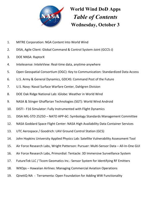
World Wind DoD Apps<br />
<strong>Table</strong> <strong>of</strong> <strong>Contents</strong><br />
Wednesday, October 3<br />
1. MITRE Corporation: NGA Content Into World Wind<br />
2. DISA, Agile Client: Global Command & Control System-Joint (GCCS-J)<br />
3. DOE NNSA: RaptorX<br />
4. Intelesense: InteleView: Real-time data, anytime-anywhere<br />
5. Open Geospatial Consortium (OGC): Key to Communication: Standardized Data Access<br />
6. U.S. Army & General Dynamics, GDC4S: Command Post <strong>of</strong> the Future<br />
7. U.S. Navy: Naval Surface Warfare Center, Dahlgren Division<br />
8. DOE Oak Ridge National Lab: iGlobe: Weather in World Wind<br />
9. NASA & Stinger Ghaffarian Technologies (SGT): World Wind Android<br />
10. DiSTI - F16 Simulator: Fully Instrumented with Flight Dynamics<br />
11. DISA MIL-STD 2525D – NATO APP-6C: Symbology Standards Management Committee<br />
12. NASA Goddard Space Flight Center: NASA High Availability Data Container Services<br />
13. UTC Aerospace / Goodrich: UAV Ground Control Station (GCS)<br />
14. John Hopkins University Applied Physics Lab: Satellite Vulnerability Assessment Tool<br />
15. Air Force Research Labs, Wright Patterson: Pursuer: Multi-Sensor Data – All-In-One GUI<br />
16. Air Force Research Labs, Primordial: Tentacle: 3D Immersive Surveillance System<br />
17. FutureTek LLC / Ticom Geomatics Inc.: Sensor System for Identifying RF Emitters<br />
18. WXOps – Hawaiian Airlines: Managing Commercial Aviation Operations<br />
19. QinetiQ-NA - Terramenta: Open Foundation for Adding WW Functionality
Feeding World Wind/Agile Client with NGA Content<br />
Xander Enzmann, MITRE Corporation<br />
The National Geospatial-Intelligence Agency (NGA) provides a large amount <strong>of</strong> content<br />
for use in Command and Control planning and execution. This presentation will<br />
describe how much <strong>of</strong> that information can be processed and used in an efficient way by<br />
World Wind in connected and disconnected environments. The AgileClient framework<br />
from DISA is used as the presentation framework that houses World Wind.<br />
The delivery <strong>of</strong> NGA provided content can take<br />
many forms: OGC services such as WMS; KML<br />
overlays; raster images (JPEG2000, MrSID, RPF);<br />
vector files (ESRI Shapefiles, VPF), … Content can<br />
be stored in a number <strong>of</strong> different ways with choices<br />
dependent on how much is needed, bandwidth and<br />
processor considerations, … In addition to raw<br />
content, map services can be a filter/transformation<br />
engine for local and external MCG&I services.<br />
The environments in which this content is needed<br />
range from globally connected force level systems<br />
to small enclaves to individual planners. There are<br />
many FOSS spatial processing libraries (e.g., OGDI,<br />
GDAL), spatially aware databases such as<br />
Postgres/PostGIS, and caching tools. Using these,<br />
NGA content can be managed, processed, and made<br />
available to a planner as selectable layers for display. This presentation will briefly<br />
describe the tools and techniques that can be applied to this end.<br />
xander@mitre.org
Agile Client<br />
GCCS-J Collaboration in 3D<br />
Agile Client is a Command and Control (C2) application providing a common operational picture in 3D.<br />
• Agile Client is an independently accredited C2 application, currently fielded and used by the<br />
combatant commands and the AOC.<br />
• Uses World Wind to render an advanced 3-D model <strong>of</strong> the world. As an open source library,<br />
Agile Client plug-ins can take advantage <strong>of</strong> the many tools available within World Wind.<br />
• A modular rich-client application built using the Oracle NetBeans rich client framework<br />
provides for easily extensible adaptability and advanced design.<br />
• Numerous plug-ins developed using the Agile Client/World Wind SDK. Agile Client apps can<br />
use DISA’s streamlined accreditation process to support a wide variety <strong>of</strong> missions and users.<br />
Track History<br />
Report<br />
Track History<br />
Replay Button<br />
Agile Client:<br />
- Subscribes to data services in an agile<br />
manner.<br />
- Uses existing business logic on top <strong>of</strong><br />
COTS whenever possible.<br />
- Works in both connected and<br />
disconnected environments.<br />
- Content delivery system positions<br />
data on the network and maximizes<br />
application memory.<br />
Agile Client includes functionality for:<br />
- Real time chat & geo-collaboration leveraging<br />
open standards used by DCO, Facebook, and<br />
Google Talk.<br />
- The MIL-STD 2525 based plot management<br />
framework supporting a highly scalable<br />
infrastructure for common filtering, plot<br />
controls and time-projection algorithms<br />
- Application framework for placing menu items<br />
and organizing application binaries.<br />
Forge.Mil Project: https://s<strong>of</strong>tware.forge.mil/sf/projects/agile_client<br />
Sal.Cardinale@ngc.com , Agile Client Lead Developer, Northrop Grumman
3D C4ISR<br />
Computer-based<br />
Command<br />
Control<br />
Communications<br />
Intelligence<br />
Surveillance<br />
Reconnaissance<br />
Fully Extensible<br />
Open API<br />
Plug-in driven<br />
Developer training and conferences<br />
Customized to your mission requirements<br />
Community Driven<br />
Open API<br />
Conferences and training<br />
Benefit from other people’s innovation<br />
Share your additions as you see fit<br />
Free!<br />
100% Free<br />
Government Use Only<br />
Nolicensing<br />
No maintenance costs<br />
Only pay for your additions<br />
RaptorX is available to the US Government Intelligence Community and their contractors only.<br />
To obtain a copy <strong>of</strong> RaptorX, please contact: Jay Nance, S<strong>of</strong>tware Manager at NanceJA@nv.doe.gov
Advanced Sensors, Data Integration, Visualization and Collaboration<br />
for Force Health Protection and Situational Awareness<br />
Kevin Montgomery, CEO Intelesense.com<br />
Our goal is to provide real-time multimodal data from the field, integrated with multiple<br />
data sources for system delivering continual situational awareness and collaboration.<br />
Intelesense has been developing, deploying<br />
and improving an integrated suite <strong>of</strong> ISR<br />
sensor technologies across DoD operations<br />
for medical and environmental data.<br />
This is accomplished via a secure online<br />
Portal using plug-and-play modular<br />
architecture for real-time data acquisition,<br />
transmission, integration, analysis and<br />
display. This data comes together in a<br />
collaborative framework providing a ‘live’<br />
stream for highly informed decision support.<br />
Supported devices include a suite <strong>of</strong> medical and environmental sensors that have been<br />
field tested and made operational. The devices and their integration system are deployed<br />
worldwide for a number <strong>of</strong> operations, including Disaster Response, Border Patrol and<br />
Personnel Exposure Management. This presentation will include results <strong>of</strong> requirements<br />
analysis serving operational needs for DOD, DHS and other government partners.<br />
We will include a live<br />
demo <strong>of</strong> the immediate<br />
access to sensors<br />
distributed worldwide.<br />
Technology resulting<br />
from this extraordinary<br />
access to remote<br />
conditions has provided<br />
new opportunities for<br />
telemedicine,<br />
environmental sensing<br />
and dramatically<br />
enhanced situational<br />
awareness.<br />
Kevin Montgomery Ph.D. is a Senior Researcher at the Center for Innovation in Global Health at Stanford University,<br />
a Portfolio Manager with TATRC (US Army MRMC) and an advisor to the Air Force Office <strong>of</strong> Modernization (AFMSA).
A Unique Organization<br />
Offering Unique Benefits<br />
Geospatial technologies play an important role in business, government, and research<br />
applications and workflows. However, the benefits <strong>of</strong> using these technologies are <strong>of</strong>ten<br />
limited by the inability to effectively share information. To address this problem,<br />
government, private sector, and academic organizations use the OGC consensus process<br />
to cooperatively define, develop, test, document, validate and approve interface and<br />
encoding standards and best practices that solve interoperability problems.<br />
With more than 400 member organizations worldwide, the Open Geospatial Consortium<br />
(OGC) is the leading organization for developing and maintaining international<br />
geospatial and location standards. The OGC is a not-for-pr<strong>of</strong>it voluntary consensus<br />
standards organization whose standards enable interoperability and seamless integration<br />
<strong>of</strong> location information, geoprocessing s<strong>of</strong>tware, and geospatial services.<br />
Benefits for Technology and Content Providers<br />
Technology and content providers collaborate in the OGC because they recognize that<br />
lack <strong>of</strong> interoperability is a bottleneck that slows market expansion. They know that<br />
interoperability enabled by open standards positions them to both compete more<br />
effectively in the marketplace and to seek new market opportunities.<br />
In the OGC, technology and content provider members:<br />
• Position themselves early to influence definition <strong>of</strong> new open standards.<br />
• Reduce costs through cooperative standards development with other OGC<br />
members.<br />
• Shorten time to market by using OGC standards rather than custom interfaces.<br />
• Develop standards that help them enter new markets and find new customers<br />
because <strong>of</strong> "plug and play".<br />
• Forum for discussing industry issues and solving shared problems.<br />
• Customer relationships and business partnerships.<br />
• Deliver solutions more quickly and at lower cost.<br />
• Develop standards that help mobilize a range <strong>of</strong> products across open interfaces,<br />
rather than performing resource intensive custom integration.<br />
• Provide precise solutions to meet specific needs, solutions that plug-and-play.<br />
Nadine Alameh<br />
Director, Interoperability Programs<br />
Open Geospatial Consortium (OGC)<br />
nalameh@opengeospatial.org<br />
Phone: +703 501 3074
General Dynamics C4 Systems: Command Post <strong>of</strong> the Future (CPOF)<br />
www.gdc4s.com/CPOF<br />
Eric Gardner, Eric.Gardner@gdc4s.com<br />
Gerard Tria, gerard.tria@us.army.mil<br />
In partnership with the U.S. Army and PM Mission Command, General Dynamics C4 Systems<br />
is fielding a state-<strong>of</strong>-the-art visualization and collaboration system to today’s warfighters<br />
worldwide. Command Post <strong>of</strong> the Future (CPOF) is an executive-level system providing<br />
situational awareness and collaborative tools to support decision-making. The system can be<br />
tailored to show specific visualizations and fit user needs across all warfighting functions and<br />
organizations from Corps to Battalion. This tool suite uses General Dynamics’ CoMotion®<br />
technology. CoMotion provides information analysis, visualization and collaboration in a<br />
single, integrated environment that ultimately helps commanders and decision-makers make<br />
sense <strong>of</strong> information, share thoughts, evaluate courses <strong>of</strong> action and monitor their execution.<br />
• CPOF creates a rich multi-perspective and shared operational picture.<br />
• CPOF supports distributed and collaborative planning, whether for rehearsal or execution,<br />
allowing the Commander to command the battlefield from anywhere.<br />
CPOF's greatest strength is its consistent, easy-to-use information-centric interface.<br />
The key design concepts are:<br />
• Composability - Warfighters can access, view, and tune individual data elements,<br />
visualizations, and composite work products yielding a user-defined operational picture.<br />
• Next-Generation Collaboration – From disparate locations, commanders and staff can<br />
naturally work together to generate, share and evaluate Courses <strong>of</strong> Action (COAs),<br />
Operation Orders, Commanders Orders and more. Every visualization and work product in<br />
CPOF is collaborative from the moment the system is turned on. The always-on sharing<br />
supports self-synchronization, which minimizes interruptions and allows the commander<br />
and staff to manage, maintain and share their C2 resources and expertise.<br />
• Visualization - Users work with live operational data that moves easily across<br />
visualization products, automatically taking the appropriate form (geospatial, temporal,<br />
textual, etc). This “liquid information” allows each user to display information the way he<br />
or she thinks about it.
Maestro in World Wind: Modeling and Simulation<br />
Naval Surface Warfare Center, Dahlgren Division (NSWCDD)<br />
Clinton.Winfrey@navy.mil<br />
Through recent R&D efforts, NSWCDD has prototyped a tool that allows for easy<br />
implementation <strong>of</strong> the DEVS modeling and simulation formalism.<br />
Discrete Event System Specification, is a modular and hierarchical<br />
formalism for modeling and analyzing general systems that can be<br />
discrete event systems. These may be described by state transition<br />
tables and continuous state systems which themselves may be described<br />
by differential equations, and hybrid continuous state and discrete event<br />
systems. DEVS is a timed event system. The DEVS formalism was<br />
invented by Dr. Bernard Ziegler, University <strong>of</strong> Arizona.<br />
In one implementation, we use World Wind to visually display the environment.<br />
Model, experimental, and simulation frames can all be developed separately via the<br />
methods used in this approach.
iGlobe: Bringing Weather and Climate to a 3D Globe<br />
Varun Chandola, Oak Ridge National Laboratory<br />
The growing understanding <strong>of</strong> changing climate and its impact on the environment and society has<br />
propelled heavy research investment in the area <strong>of</strong> climate modeling resulting in sophisticated<br />
models that can capture multitudes <strong>of</strong> scenarios and produce realistic forecasts at decadal and<br />
century scales and produce simulation outputs which are valuable data sources for understanding<br />
climate change impacts.<br />
At the same time, path breaking advances in remote<br />
sensing technology has enabled measuring and<br />
storing weather data at an unprecedented rate.<br />
The dense scientific format in which such climate<br />
and weather data is stored, NetCDF and HDF, makes<br />
it a challenge to visualize as geospatial data in 4D<br />
environments such as NASA WorldWind and Google<br />
Earth, where they truly belong for effective<br />
visualization and analysis in concert with traditional<br />
geospatial data sets, such as terrain, infrastructure, demographics, and other data.<br />
The Geographic Information Science and Technology (GIST) group at Oak Ridge National<br />
Laboratory, in collaboration with researchers from Australia’s Commonwealth Scientific and<br />
Industrial Research Organization (CSIRO), University Corporation<br />
for Atmospheric Research (UCAR) and University <strong>of</strong> Kansas has<br />
developed iGlobe, an open source desktop application that puts<br />
climate research and weather data in a 3D globe where it can be<br />
visualized and analyzed with other geospatial data.<br />
iGlobe is based on NASA World Wind with significant<br />
enhancements to ingest climate model outputs (i.e., NetCDF files)<br />
and display them on a 3D globe. The application is capable <strong>of</strong><br />
handling complex visualizations such as time varying animations,<br />
elevations, and vector field rendering.<br />
The analytic core <strong>of</strong> iGlobe allows users to interact with the<br />
different data sets using sophisticated data analysis tools to<br />
perform complex operations such as anomaly detection,<br />
spatiotemporal change detection, signal analysis, and connected<br />
component detection that all take place on the ‘back-end’ server.<br />
The server-side analysis component <strong>of</strong> iGlobe allows analysis on<br />
high-end servers with the results visualized on the client. Since the<br />
analysis outputs are typically magnitudes smaller than the original<br />
data sets, the burden on network resources is minimized.<br />
chandolav@ornl.gov
TAIGA<br />
Traffic and Atmospheric Information for General Aviation<br />
Alaska <strong>of</strong>fers a combination <strong>of</strong> difficult flying conditions and a heavy dependence upon<br />
aviation to support its way <strong>of</strong> life. The result is a sobering set <strong>of</strong> statistics describing a<br />
disproportionate number <strong>of</strong> aviation accidents and fatalities compared to the lower 48 states.<br />
TAIGA is a joint venture between NASA Ames Research Center and the State <strong>of</strong> Alaska to<br />
help pilots make better decisions before and during flight. We will accomplish this by<br />
building a system customized to the needs <strong>of</strong> Alaskan flights. This involves building<br />
communication systems, collecting appropriate data, delivering data to the cockpit, and<br />
visualizing that data in a useful way. For this last goal, we will use the Android platform and<br />
NASA World Wind. The data in question will include weather, traffic, and volcanic activity<br />
amongst others.<br />
We have developed an initial desktop<br />
demonstration <strong>of</strong> the visualization to<br />
appear on an Android tablet. Work<br />
has begun porting World Wind to the<br />
Android platform.<br />
The code resulting from this work<br />
will be made available as open<br />
source. It is hoped this will spur<br />
further Android/World Wind projects<br />
in the future.<br />
The most dangerous work site in Alaska is a<br />
small plane and the fatality rate for Alaska<br />
pilots (General Aviation & Commercial)<br />
is five times greater than the rate for all<br />
US pilots.<br />
- Alaska Aviation Safety Project citing FAA statistics<br />
To reduce occupational fatalities resulting<br />
from aircraft crashes in the state, safety<br />
interventions should focus on providing<br />
weather and other flight information to<br />
increase pilots’ situational awareness… and<br />
expanding the infrastructure used by pilots<br />
to fly by instruments.<br />
- CDC report on Alaskan occupational fatalities<br />
Contact Joseph.L.Rios@nasa.gov for more information
DiSTI’s GL Studio and World Wind Integration<br />
www.disti.com<br />
Ben Ellis, bellis@disti.com<br />
DiSTI is a leading provider <strong>of</strong> advanced graphical interface technology used to empower<br />
Human Machine Interface (HMI) development and virtual maintenance training. DiSTI’s<br />
flagship product, GL Studio, is a graphical development tool, laid out similar to Photoshop, that<br />
enables users to build and integrate high fidelity and feature rich 2D and 3D applications,<br />
enhancing levels <strong>of</strong> realism and sophistication.<br />
GL Studio enables the creation <strong>of</strong> 2D and 3D geometry in real time through a WYSIWYG<br />
environment, alleviating the need to write cumbersome OpenGL code. The GL Studio Editor<br />
features include basic tools for drawing, grouping, ordering and texturing.<br />
Fully instrumented F-16<br />
with F-16 flight dynamics.<br />
Fly there before and after:<br />
• Mission planning<br />
• Mission debriefing<br />
• Training<br />
Designs are implemented<br />
using the GL Studio<br />
Runtime Engine. This<br />
allows for real-time<br />
design and deployment.<br />
GL Studio’s Java code generator produces pure<br />
Java code compatible with any operating<br />
system utilizing the Java Runtime Environment<br />
(JRE).<br />
GL Studio products easily integrate with<br />
NASA World Wind to create applications for<br />
high fidelity graphical instrumentation overlays<br />
suitable for:<br />
• Simulators,<br />
• UAV control stations, and<br />
• Telemetry visualization, etc.
NASA Goddard Space Flight Center<br />
World Wind in the Cloud<br />
October 2012<br />
Adrian Gardner, Chief Information Officer,
Ground<br />
Control<br />
Station<br />
(GCS)<br />
Ground Control Station (GCS) is an intuitive, mission-centric user interface for Small<br />
Unmanned Aircraft Systems (SUAS) users and only requires a minimal number <strong>of</strong> operator<br />
actions to perform any task. GCS utilizes a tablet/smartphone-style gesture based interface,<br />
where only 1-2 clicks are required for most mission planning and mission execution tasks.<br />
There is a high level <strong>of</strong> automation designed into the s<strong>of</strong>tware, resulting in rapid flight mission<br />
planning both during pre-flight and inflight operations. The GCS s<strong>of</strong>tware can operate multiple<br />
small UAVs at once through an intuitive mission management system.<br />
GCS is interoperable with the NATO<br />
standard open architecture and is<br />
compatible with STANAG 4586 for<br />
command and control <strong>of</strong> air vehicles,<br />
payloads, and data links, as well as<br />
STANAG 4609 for payload products.<br />
GCS utilizes high resolution terrain data<br />
during flight-planning to prevent terrain<br />
incursion and ensure line-<strong>of</strong>-sight.<br />
The service-oriented architecture supports rapid integration <strong>of</strong> third party subsystem solutions<br />
and features an IP-based communications architecture facilitating simple integration with IP<br />
enabled services such as Payload Exploitation and Dissemination (PED) services or external<br />
mission planning systems, as well as simple injection <strong>of</strong> external data objects such as friendlyforce<br />
location data and dissemination <strong>of</strong> payload and/or mission data over Ethernet networks.<br />
Jaya.Kokotovich@utas.utc.com
Satellite Vulnerability Assessment Tool<br />
Nigel.Tzeng@jhuapl.edu<br />
Ensuring the health and safety <strong>of</strong> satellites is a primary component <strong>of</strong> any satellite<br />
operations center. To this end, there is a need to reduce the manual effort and time<br />
required to monitor and respond to satellites through enhanced automated services.<br />
Being able to visualize this information in its actual geospatial context allows<br />
immediate understanding <strong>of</strong> the issues involved affording intelligent and effective<br />
response. NASA World Wind, a fully extendable 3D geospatial visualization<br />
technology provides the interface for compelling delivery <strong>of</strong> satellites’ status and<br />
environment.<br />
The Johns Hopkins University Applied Physics Laboratory (JHU/APL) has<br />
extensive experience incorporating technologies into the NASA World Wind<br />
visualization platform, to create a dynamic environment for Situational Awareness<br />
that will prove invaluable to government and commerce.
TECHNOLOGY MILESTONES<br />
Pursuing Multisensor GUI Advances<br />
AFRL-developed Pursuer technology provides users a graphical user interface for assimilating multisensor imagery and<br />
metadata for review in one composite display. (AFRL image)<br />
AFRL sensors scientists have developed<br />
a graphical user interface (GUI) capable<br />
<strong>of</strong> assimilating wide-area motion imagery,<br />
ground-based sensor data, and narrow-field<strong>of</strong>-view<br />
sensor overlays for review in one<br />
composite display composed <strong>of</strong> multisensor<br />
imagery and associated metadata.<br />
Dubbed Pursuer, the technology builds<br />
upon the National Aeronautics and Space<br />
Administration’s (NASA) World Wind Java, a<br />
s<strong>of</strong>tware engine that overlays NASA and US<br />
Geological Survey satellite imagery, aerial<br />
photography, topographic maps, and publicly<br />
available geographical information system<br />
data on three-dimensional models <strong>of</strong> earth<br />
and other planets. Accordingly, AFRL’s<br />
Pursuer provides a time model that enables<br />
users to step through a collection <strong>of</strong> sensor<br />
data in a “TiVo-like” (i.e., digital-videorecording-type)<br />
capacity. The technology also<br />
incorporates a variety <strong>of</strong> additional tools—such<br />
as frame-to-frame stabilization, brightness/<br />
contrast adjustment, user markup annotation,<br />
screen capture, distance calculator, manual<br />
tracking, and movie creation—enabling users<br />
to exploit the captured sensor data to the<br />
fullest possible extent.<br />
AFRL is working to further develop Pursuer<br />
by hosting the product in a collaborative<br />
s<strong>of</strong>tware environment known as Forge.mil.<br />
Similar to the open source Sourceforge.<br />
net s<strong>of</strong>tware development site, Forge.mil<br />
<strong>of</strong>fers Department <strong>of</strong> Defense developers a<br />
secure collaboration environment controlled<br />
by Common Access Card authentication<br />
and security. Interested (authorized) parties<br />
can access the Pursuer source code under<br />
the RYA – SPADE [AFRL Sensors<br />
Directorate, Automatic Target Recognition –<br />
Spatially Diverse Electronic Attack] project on<br />
Forge.mil.<br />
For additional information on this technology contact AFRL/RY afrl.ry.marketing@wpafb.af.mil, (937)904-9771. To receive more information about AFRL,<br />
visit the Homepage at www.wpafb.af.mil/afrl. (RY-10-08_04-15) Sensors/Response to Needs<br />
DISTRIBUTION A - PUBLIC RELEASE
PRIMORDIAL.COM<br />
Tentacle TM - 3D Immersive Surveillance System<br />
Primordial’s Tentacle s<strong>of</strong>tware reduces operator overload by fusing multiple sensor feeds<br />
into a single 3D surveillance display, leveraging NASA World Wind for 3D rendering.<br />
The development <strong>of</strong> the Tentacle project is currently being funded with an Air Force<br />
Research Laboratory (AFRL) Small Business Innovation Research (SBIR) phase II contract.<br />
Tentacle supports entity tracking from static surveillance cameras, and during phase II<br />
it will be updated to also supported moving cameras e.g. from unmanned aerial vehicles<br />
(UAVs) or unmanned ground vehicles (UGVs).<br />
The entities extracted from these videos are automatically placed into a single threedimensional<br />
(3D) display so that one analyst will be able to effectively monitor dozens <strong>of</strong><br />
cameras. Tentacle’s World Wind-based 3D display includes imagery, terrain, buildings,<br />
and avatars representing entities such as people and vehicles. During phase II the avatars<br />
will be updated, likely using 3D Collada models embedded in World Wind, in order to<br />
provide a more realistic representation <strong>of</strong> the tracked entities.<br />
Tentacle also supports analyzing behavior and providing alerts (e.g. crossed tripwire or<br />
abandoned bag), and it is being updated in phase II with additional behavior analytics,<br />
improved capabilities for extracting metadata (e.g. person versus vehicle, upper color, and<br />
lower color), support for performing real-time queries (e.g. highlight people wearing red<br />
shirts), as well as archived queries <strong>of</strong> video and metadata.<br />
For this project, Primordial has teamed with intuVision, All Hazards Management (AHM),<br />
and Carnegie Mellon University (CMU). intuVision is a leader in surveillance camera<br />
tracking and alerts, CMU provides expertise in tracking vehicles from UAVs including the<br />
Raven, and AHM is assisting with development for the 3D display.<br />
1021 Bandana Boulevard East, Suite 225 • Saint Paul, MN • 55108<br />
Phone: (651) 395-6200 • Fax: (651) 644-1294
GEOnet: Networked-based Sensor System for Locating RF Emitters<br />
FutureTek S<strong>of</strong>tware Consulting LLC<br />
Rob Ratcliff - rob@futuretek.com 512-633-5751<br />
A NASA World Wind based NetBeans plug-in was developed for the<br />
Ticom Geomatics (www.ticom-geo.com) GEOnet operator interface for the<br />
3D alternative to the currently used 2D GIS package. GEOnet is a networkedbased<br />
sensor system for finding RF emitters.<br />
∙∙∙∙∙ Field <strong>of</strong> View (FOV)<br />
----- Area <strong>of</strong> Interest (AOI)<br />
The GEOnet displays the dilution <strong>of</strong> precision (DOP) contour plot<br />
and the fields <strong>of</strong> view (FOV) for the active sensors and the AOI.<br />
World Wind was selected since it could be readily embedded in a Java application<br />
using its stable and performant Java API. World Wind also enables access to many<br />
popular GIS data formats supplied by map data servers via the open WMS standard.<br />
In addition, the GEOnet GUI could readily leverage many <strong>of</strong> the built-in<br />
capabilities <strong>of</strong> World Wind such as measuring tools, 2D/3D projections, direct<br />
importing <strong>of</strong> GeoTIFFs, VPF and ESRI Shapefiles, the <strong>of</strong>f-line map data cache,<br />
line-<strong>of</strong>-site prediction, KML rendering, analytic surfaces and MGRS support.<br />
www.futuretek.com
World Wind for Aviation Operations<br />
WxOps.com<br />
Dr. Scott T. Shipley, scott@wxops.com;<br />
Mark Spence, Chief <strong>of</strong> Dispatch Operations, Mark.spence@hawaiianair.com<br />
World Wind has been selected as the next generation geobrowser for Dispatch Operations<br />
at Hawaiian Airlines. Adapted by WxOps, Inc., this geobrowser is being integrated into<br />
the current Hawaiian Dispatch S<strong>of</strong>tware Suite (DSS) and the upcoming Hawaiian Airlines<br />
Electronic Flight Bag (EFB) system. Hawaiian is pioneering a geobrowser-based<br />
"Common Operating Environment" which is providing useful insights into potential<br />
NextGen tools and applications. WxOps will discuss key factors leading to the selection <strong>of</strong><br />
World Wind and its advantages in applications for global and trans-oceanic aviation<br />
operations.<br />
For more information, please contact Albert Peterlin, WxOps COO albert@wxops.com<br />
WxOps Inc. is a Hawaii<br />
based company providing<br />
state <strong>of</strong> the art<br />
transportation and weather<br />
support products to<br />
industry and government.<br />
WxOps uses 4D Virtual<br />
Globe and other<br />
technologies to visualize<br />
and control transportation<br />
operations in response to<br />
rapidly changing<br />
conditions on local and<br />
global scales.<br />
4-Dimensional geospatial operations with NEXRAD and CloudSat<br />
radar using World Wind JAVA, demonstrating animation and<br />
transparency in a demanding Common Operating Environment.<br />
http://wxops.com/public/WorldWind.html<br />
About Hawaiian Airlines:<br />
Now in its 81st year <strong>of</strong><br />
continuous service for<br />
Hawaii, Hawaiian is the<br />
State's biggest and<br />
longest-serving airline, as well as the largest provider <strong>of</strong> passenger air service to Hawaii<br />
from the State's primary visitor markets on the U.S. mainland.<br />
Hawaiian <strong>of</strong>fers nonstop service to Hawaii from more U.S. gateway cities than any other<br />
airline, as well as service to the Philippines, Australia, American Samoa, Tahiti, Japan,<br />
South Korea and New Zealand. Hawaiian also provides more than 150 daily jet flights<br />
between the Hawaiian Islands. Hawaiian Airlines, Inc. is a subsidiary <strong>of</strong> Hawaiian<br />
Holdings, Inc. (NASDAQ: HA).<br />
Copyright (2012) WxOps, Inc. All Rights Reserved.
Terramenta is built on top <strong>of</strong> the NetBeans<br />
Platform application framework. The<br />
NetBeans Platform provides a rich set <strong>of</strong><br />
capabilities including a windowing<br />
framework, action system, and a mature<br />
set <strong>of</strong> APIs and services for plug-in<br />
development and management. NetBeans<br />
also has an established community that<br />
provides a wealth <strong>of</strong> tutorials, FAQs, and<br />
books.<br />
Terramenta makes extensive use <strong>of</strong> NASA’s<br />
World Wind to create a rich user<br />
experience working with geospatial data.<br />
Have a World Wind Java (WWJ) feature<br />
you would like to use Terramenta brings<br />
the WWJ framework to your plug-in.<br />
Terramenta is a Java s<strong>of</strong>tware application<br />
that can run on Micros<strong>of</strong>t Windows, Mac<br />
OS X, and Linux operating systems.<br />
Te r r a m e n t a w o r k s f o r y o u r<br />
G e o s p a t i a l a n d V i s u a l i z a t i o n n e e d s .<br />
Through the use <strong>of</strong> NASA World Wind and the NetBeans Platform,<br />
Terramenta is an open source foundation for your geospatial<br />
applications. Terramenta is a Geographic Information System (GIS)<br />
desktop application designed to interact with nearly any type <strong>of</strong> data<br />
that can be presented to a user. Terramenta supports a wide range <strong>of</strong><br />
community formats and standards including GeoTIFF, DTED, KML,<br />
GML, GeoJSON, GeoRSS, and WMS. It supports rich user interaction<br />
for graphics and analysis capabilities and focuses on providing a clean<br />
modular system so that new functionality can quickly be introduced<br />
within a community <strong>of</strong> interest.<br />
Terramenta inherits tremendous<br />
support through the use <strong>of</strong> the NetBeans and NASA World Wind opensource<br />
project communities.<br />
Terra = The world.<br />
Ferramenta = Tool <strong>of</strong> iron.<br />
∴ Terramenta = World Tool<br />
bitbucket.org/heidtmare/terramenta<br />
Chris.Heidt@QinetiQ-NA.com
GeoServer and OpenGeo Suite with World Wind<br />
Ilya Rosenfeld<br />
irosenfeld@opengeo.org<br />
GeoServer is a full-featured s<strong>of</strong>tware server for sharing and editing <strong>of</strong><br />
geospatial data. GeoServer allows using most major spatial databases<br />
and file formats as data sources. Built to be a spatial interoperability server and a core<br />
building block <strong>of</strong> the geospatial web, GeoServer provides an easy means to publish data<br />
as standards-compliant web services. GeoServer is the reference implementation <strong>of</strong> the<br />
Open Geospatial Consortium (OGC) Web Feature Service (WFS) and Web Coverage<br />
Service (WCS) standards, as well as a high performance, OGC-certified Web Map<br />
Service (WMS). In addition to providing standards-based mapping and data web services,<br />
GeoServer is as a robust platform for scripting and deploying processing logic as OGCcompliant<br />
Web Processing Services (WPS).<br />
GeoServer is continuously developed and tested by a community <strong>of</strong> individual<br />
contributors and organizations around the world. It is licensed as free s<strong>of</strong>tware under<br />
GPL 2.0 license.<br />
GeoServer source code and multi-platform binary releases are freely available online<br />
along with extensions and complete user, developer and API documentation.<br />
Implemented as a Java web application, GeoServer only requires a Java Virtual Machine<br />
(JVM) to run stand-alone in a bundled, Jetty lightweight servlet container. Alternatively,<br />
the Web Application Archive (.war file) distribution may be deployed to any servlet<br />
container such as Apache Tomcat. Once installed, an intuitive, browser-based<br />
administration console is used to configure data sources, services to be published,<br />
security rules, map styles, caching, performance optimizations, as well as multiple other<br />
capabilities <strong>of</strong> GeoServer.<br />
OpenGeo is an organization that employs core developers <strong>of</strong><br />
GeoServer technology and prominent expert members <strong>of</strong> communities<br />
it supports. OpenGeo provides enterprise support, training and custom<br />
development services to customers worldwide. OpenGeo is maker <strong>of</strong> OpenGeo Suite – a<br />
complete and open geospatial development platform running on the cloud, onsite, in a<br />
browser and on mobile devices. Packaged as a convenient installer, OpenGeo Suite<br />
contains all components necessary for building and deploying spatially enabled services<br />
and web applications – whether stand-alone, or in combination <strong>of</strong> other infrastructure.<br />
NASA World Wind SDK and prebuilt applications provide connectivity to multiple web<br />
services supported by GeoServer. Among these are WMS, WFS and others.<br />
Download and install GeoServer: http://geoserver.org/display/GEOS/Download<br />
Understand GeoServer License: http://geoserver.org/display/GEOS/License<br />
Use GeoServer WMS in World Wind: http://worldwind.arc.nasa.gov/java/1.2.0/demos/<br />
Get OpenGeo Suite and Support: http://opengeo.org/products/suite/
NEWS<br />
Mapgears and MGeospatial join forces to launch Mapgears Solutions<br />
Quebec, Canada, April 4, 2012 - Mapgears and Mgeospatial are pleased to announce the merge <strong>of</strong> their respective geospatial consulting activities<br />
into a new Mapgears division: Mapgears Solutions.<br />
"With the MapServer web mapping engine, we have played an active role in the open source revolution that took <strong>of</strong>f over the last decade in the<br />
geospatial field around the world", says Daniel Morissette, president <strong>of</strong> Mapgears. "The new Mapgears Solutions team will complement our current<br />
technology <strong>of</strong>fering with its highly specialized consulting services to assist our customers in the deployment <strong>of</strong> MapServer and related open source<br />
technologies, and to continue to revolutionize the geospatial field."<br />
"It is with great pleasure that I join the Mapgears team to take on this new challenge", added Simon Mercier, vice president <strong>of</strong> the new Mapgears<br />
Solutions division. "Mapgears was Mgeospatial's main technology partner and the merge <strong>of</strong> our activities was the next logical step to allow us to grow<br />
our teams and help sustain the growing demand for our services. Our goal with Mapgears Solutions is to present an innovative web mapping service<br />
<strong>of</strong>fering and to continue to deliver bleeding edge solutions to our clients."<br />
About Mapgears<br />
Members <strong>of</strong> Mapgears team have been active for over 12 years in the development <strong>of</strong> the MapServer web mapping engine and related open source<br />
technologies <strong>of</strong> the Open Source Geospatial Foundation (OSGeo). Mapgears <strong>of</strong>fers pr<strong>of</strong>essional, yet personnalized services to assist application<br />
developers and integrators who made the choice <strong>of</strong> MapServer and other OSGeo technologies such as PostGIS, GDAL/OGR, OpenLayers, GeoExt,<br />
MapFish and GeoPrisma.<br />
Mapgears counts as part <strong>of</strong> its Technology team some <strong>of</strong> the main developers <strong>of</strong> Mapserver and related open source technologies, who in turn have<br />
access to an international network <strong>of</strong> trusted partners which includes the majority <strong>of</strong> the other developers <strong>of</strong> those same s<strong>of</strong>tware packages.<br />
The new Mapgears Solutions team <strong>of</strong>fers an alternative to the traditional consulting service <strong>of</strong>fering currently available on the geospatial market. Its<br />
objective is to respond to the customer's needs with solutions and assistance services revolving around open source or even hybrid (mix <strong>of</strong> closed and<br />
open source) geosptial technologies combined with the use <strong>of</strong> agile and sustainable development methodologies which are respectful <strong>of</strong> the<br />
customer's needs.<br />
For more information<br />
Daniel Morissette, dmorissette@mapgears.com<br />
Phone: 418-696-5056 / 1-888-696-5056<br />
Simon Mercier, smercier@mapgears.com<br />
Phone : 418-559-7139<br />
Follow us on Twitter @Mapgears<br />
See also<br />
Mapgears continues its growth and launches Mapgears Solutions (Daniel Morissette's blog)<br />
Solutions Mapgears (in French on Simon Mercier's blog)<br />
Our website is being rebuilt to reflect the recent changes<br />
to Mapgears and its products and services <strong>of</strong>fering.<br />
Please come back and visit us again in a few weeks.<br />
Phone: +1 418.696.5056<br />
Toll Free: 1.888.696.5056<br />
info@mapgears.com<br />
COPYRIGHT © 2012 MAPGEARS INC.<br />
DESIGN: SOLUTION GLOBALE INFORMATIQUE